
A Pacific harbor seal swims over surf grass in the protected waters of Childrens Pool in La Jolla, California. This group of harbor seals, which has formed a breeding colony at a small but popular beach near San Diego, is at the center of considerable controversy. While harbor seals are protected from harassment by the Marine Mammal Protection Act and other legislation, local interests would like to see the seals leave so that people can resume using the beach.
Species: Pacific harbor seal, Phoca vitulina richardsi
Location: La Jolla, California
Image ID: 03021
Species: Pacific harbor seal, Phoca vitulina richardsi
Location: La Jolla, California
Image ID: 03021

A Pacific harbor seal hauls out on a sandy beach. This group of harbor seals, which has formed a breeding colony at a small but popular beach near San Diego, is at the center of considerable controversy. While harbor seals are protected from harassment by the Marine Mammal Protection Act and other legislation, local interests would like to see the seals leave so that people can resume using the beach.
Species: Pacific harbor seal, Phoca vitulina richardsi
Location: La Jolla, California
Image ID: 10427
Species: Pacific harbor seal, Phoca vitulina richardsi
Location: La Jolla, California
Image ID: 10427

San Diego City Skyline viewed from Harbor Island, storm clouds at sunrise.
Location: San Diego, California
Image ID: 28843
Panorama dimensions: 4066 x 13502
Location: San Diego, California
Image ID: 28843
Panorama dimensions: 4066 x 13502
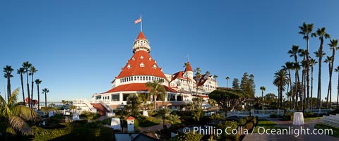
Hotel del Coronado, known affectionately as the Hotel Del. It was once the largest hotel in the world, and is one of the few remaining wooden Victorian beach resorts. It sits on the beach on Coronado Island, seen here with downtown San Diego in the distance. It is widely considered to be one of Americas most beautiful and classic hotels. Built in 1888, it was designated a National Historic Landmark in 1977.
Location: San Diego, California
Image ID: 27104
Panorama dimensions: 5288 x 12696
Location: San Diego, California
Image ID: 27104
Panorama dimensions: 5288 x 12696

Pacific harbor seal swims in the protected waters of Childrens Pool in La Jolla, California. This group of harbor seals, which has formed a breeding colony at a small but popular beach near San Diego, is at the center of considerable controversy. While harbor seals are protected from harassment by the Marine Mammal Protection Act and other legislation, local interests would like to see the seals leave so that people can resume using the beach.
Species: Pacific harbor seal, Phoca vitulina richardsi
Location: La Jolla, California
Image ID: 03017
Species: Pacific harbor seal, Phoca vitulina richardsi
Location: La Jolla, California
Image ID: 03017
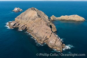
Middle Coronado Island, Mexico, looking north with San Diego and Point Loma in the distance, aerial photograph.
Location: Coronado Islands (Islas Coronado), Baja California, Mexico
Image ID: 29060
Location: Coronado Islands (Islas Coronado), Baja California, Mexico
Image ID: 29060
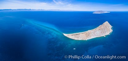
Isla San Diego and Coral Reef, reef extends from Isla San Diego to Isla San Jose, aerial photo, Sea of Cortez, Baja California.
Location: Isla San Diego, Baja California, Mexico
Image ID: 33600
Panorama dimensions: 5075 x 10543
Location: Isla San Diego, Baja California, Mexico
Image ID: 33600
Panorama dimensions: 5075 x 10543

San Diego City Skyline viewed from Harbor Island, storm clouds at sunrise.
Location: San Diego, California
Image ID: 28845
Location: San Diego, California
Image ID: 28845

Fin whale dorsal fin. The fin whale is named for its tall, falcate dorsal fin. Mariners often refer to them as finback whales. Coronado Islands, Mexico (northern Baja California, near San Diego).
Species: Fin whale, Balaenoptera physalus
Location: Coronado Islands (Islas Coronado), Baja California, Mexico
Image ID: 12771
Species: Fin whale, Balaenoptera physalus
Location: Coronado Islands (Islas Coronado), Baja California, Mexico
Image ID: 12771

This Pacific harbor seal has an ear with no external ear flaps, marking it as a true seal and not a sea lion. La Jolla, California. This group of harbor seals, which has formed a breeding colony at a small but popular beach near San Diego, is at the center of considerable controversy. While harbor seals are protected from harassment by the Marine Mammal Protection Act and other legislation, local interests would like to see the seals leave so that people can resume using the beach.
Species: Pacific harbor seal, Phoca vitulina richardsi
Location: La Jolla, California
Image ID: 01957
Species: Pacific harbor seal, Phoca vitulina richardsi
Location: La Jolla, California
Image ID: 01957

Full moon, Torrey Pine and eroded sandstone. The Torrey Pine is the rarest native pine tree in the United States, is native to the coastal chaparral of San Diego County. A subspecies of the Torrey Pine is found in a small grove on Santa Rosa island, one of Californias Channel Islands.
Species: Torrey pine, Pinus torreyana
Location: La Jolla, California
Image ID: 28987
Species: Torrey pine, Pinus torreyana
Location: La Jolla, California
Image ID: 28987
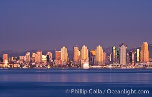
San Diego downtown city skyline and waterfront, sunset reflections and San Diego Bay. Earth-shadow (Belt of Venus) visible in the atmosphere.
Location: San Diego, California
Image ID: 27103
Location: San Diego, California
Image ID: 27103

San Diego downtown city skyline and waterfront, sunrise, dawn, viewed from Coronado Island.
Location: San Diego, California
Image ID: 27088
Panorama dimensions: 5392 x 15528
Location: San Diego, California
Image ID: 27088
Panorama dimensions: 5392 x 15528

San Diego downtown city skyline and waterfront, sunrise, dawn, viewed from Coronado Island.
Location: San Diego, California
Image ID: 27091
Location: San Diego, California
Image ID: 27091

San Diego downtown city skyline and waterfront, sunrise, dawn, viewed from Coronado Island.
Location: San Diego, California
Image ID: 27093
Location: San Diego, California
Image ID: 27093

San Diego downtown city skyline and waterfront, sunset reflections and San Diego Bay. Earth-shadow (Belt of Venus) visible in the atmosphere.
Location: San Diego, California
Image ID: 27102
Location: San Diego, California
Image ID: 27102
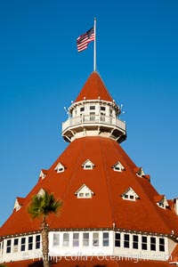
Hotel del Coronado, known affectionately as the Hotel Del. It was once the largest hotel in the world, and is one of the few remaining wooden Victorian beach resorts. It sits on the beach on Coronado Island, seen here with downtown San Diego in the distance. It is widely considered to be one of Americas most beautiful and classic hotels. Built in 1888, it was designated a National Historic Landmark in 1977.
Location: San Diego, California
Image ID: 27107
Location: San Diego, California
Image ID: 27107

San Diego bay and skyline at sunrise, viewed from Coronado Island.
Location: San Diego, California
Image ID: 27173
Panorama dimensions: 3677 x 10953
Location: San Diego, California
Image ID: 27173
Panorama dimensions: 3677 x 10953

Hotel del Coronado with holiday Christmas night lights, known affectionately as the Hotel Del. It was once the largest hotel in the world, and is one of the few remaining wooden Victorian beach resorts. It sits on the beach on Coronado Island, seen here with downtown San Diego in the distance. It is widely considered to be one of Americas most beautiful and classic hotels. Built in 1888, it was designated a National Historic Landmark in 1977.
Location: San Diego, California
Image ID: 27401
Location: San Diego, California
Image ID: 27401
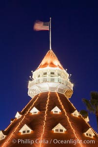
Hotel del Coronado with holiday Christmas night lights, known affectionately as the Hotel Del. It was once the largest hotel in the world, and is one of the few remaining wooden Victorian beach resorts. It sits on the beach on Coronado Island, seen here with downtown San Diego in the distance. It is widely considered to be one of Americas most beautiful and classic hotels. Built in 1888, it was designated a National Historic Landmark in 1977.
Location: San Diego, California
Image ID: 27403
Location: San Diego, California
Image ID: 27403

Hotel del Coronado with holiday Christmas night lights, known affectionately as the Hotel Del. It was once the largest hotel in the world, and is one of the few remaining wooden Victorian beach resorts. The Hotel Del is widely considered to be one of Americas most beautiful and classic hotels. Built in 1888, it was designated a National Historic Landmark in 1977.
Image ID: 36619
Image ID: 36619

Young California sea lion pup swimming underwater, Coronado Islands near San Diego, Baja California, Mexico.
Species: California sea lion, Zalophus californianus
Location: Coronado Islands (Islas Coronado), Baja California, Mexico
Image ID: 40743
Species: California sea lion, Zalophus californianus
Location: Coronado Islands (Islas Coronado), Baja California, Mexico
Image ID: 40743

Inquisitive young California sea lion underwater inspects my glove by gently mouthing it. This is a pup-of-the-year born in June and only about five months old. Sea lions are tactile creatures and learn about objects and their surroundings by biting on them. Coronado Islands near San Diego, Baja California, Mexico.
Species: California sea lion, Zalophus californianus
Location: Coronado Islands (Islas Coronado), Baja California, Mexico
Image ID: 40768
Species: California sea lion, Zalophus californianus
Location: Coronado Islands (Islas Coronado), Baja California, Mexico
Image ID: 40768

Inquisitive young California sea lion underwater, this is a pup-of-the-year born in June and only about five months old, Coronado Islands near San Diego, Baja California, Mexico.
Species: California sea lion, Zalophus californianus
Location: Coronado Islands (Islas Coronado), Baja California, Mexico
Image ID: 40771
Species: California sea lion, Zalophus californianus
Location: Coronado Islands (Islas Coronado), Baja California, Mexico
Image ID: 40771
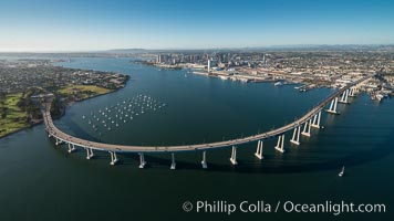
Aerial Photo of San Diego Coronado Bridge, known locally as the Coronado Bridge, links San Diego with Coronado, California. The bridge was completed in 1969 and was a toll bridge until 2002. It is 2.1 miles long and reaches a height of 200 feet above San Diego Bay. Coronado Island is to the left, and downtown San Diego is to the right in this view looking north.
Image ID: 30761
Image ID: 30761
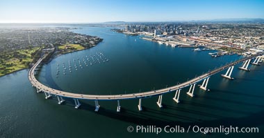
Aerial Photo of San Diego Coronado Bridge, known locally as the Coronado Bridge, links San Diego with Coronado, California. The bridge was completed in 1969 and was a toll bridge until 2002. It is 2.1 miles long and reaches a height of 200 feet above San Diego Bay. Coronado Island is to the left, and downtown San Diego is to the right in this view looking north.
Image ID: 30762
Image ID: 30762
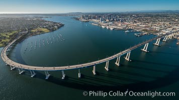
Aerial Photo of San Diego Coronado Bridge, known locally as the Coronado Bridge, links San Diego with Coronado, California. The bridge was completed in 1969 and was a toll bridge until 2002. It is 2.1 miles long and reaches a height of 200 feet above San Diego Bay. Coronado Island is to the left, and downtown San Diego is to the right in this view looking north.
Image ID: 30763
Image ID: 30763

Trachinotus rhodopus Gafftopsail pompano, Isla San Diego, Sea of Cortez.
Location: Isla San Diego, Baja California, Mexico
Image ID: 33522
Location: Isla San Diego, Baja California, Mexico
Image ID: 33522

Pacific creolefish, Paranthias colonus, Sea of Cortez.
Location: Isla San Diego, Baja California, Mexico
Image ID: 33523
Location: Isla San Diego, Baja California, Mexico
Image ID: 33523

King Angelfish, Sea of Cortez, Baja California.
Species: King angelfish, Holacanthus passer
Location: Isla San Diego, Baja California, Mexico
Image ID: 33524
Species: King angelfish, Holacanthus passer
Location: Isla San Diego, Baja California, Mexico
Image ID: 33524