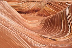
The Wave, an area of fantastic eroded sandstone featuring beautiful swirls, wild colors, countless striations, and bizarre shapes set amidst the dramatic surrounding North Coyote Buttes of Arizona and Utah. The sandstone formations of the North Coyote Buttes, including the Wave, date from the Jurassic period. Managed by the Bureau of Land Management, the Wave is located in the Paria Canyon-Vermilion Cliffs Wilderness and is accessible on foot by permit only.
Location: North Coyote Buttes, Paria Canyon-Vermilion Cliffs Wilderness, Arizona
Image ID: 20614
Location: North Coyote Buttes, Paria Canyon-Vermilion Cliffs Wilderness, Arizona
Image ID: 20614
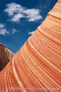
The Wave, an area of fantastic eroded sandstone featuring beautiful swirls, wild colors, countless striations, and bizarre shapes set amidst the dramatic surrounding North Coyote Buttes of Arizona and Utah. The sandstone formations of the North Coyote Buttes, including the Wave, date from the Jurassic period. Managed by the Bureau of Land Management, the Wave is located in the Paria Canyon-Vermilion Cliffs Wilderness and is accessible on foot by permit only.
Location: North Coyote Buttes, Paria Canyon-Vermilion Cliffs Wilderness, Arizona
Image ID: 20623
Location: North Coyote Buttes, Paria Canyon-Vermilion Cliffs Wilderness, Arizona
Image ID: 20623

Wire Pass narrows opens into the Buckskin Gulch. These narrow slot canyons are formed by water erosion which cuts slots deep into the surrounding sandstone plateau. This is a panorama created from ten individual photographs.
Location: Wire Pass, Paria Canyon-Vermilion Cliffs Wilderness, Arizona
Image ID: 20705
Panorama dimensions: 4366 x 16390
Location: Wire Pass, Paria Canyon-Vermilion Cliffs Wilderness, Arizona
Image ID: 20705
Panorama dimensions: 4366 x 16390
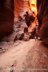
Hiker in Buckskin Gulch. A hiker considers the towering walls and narrow passageway of Buckskin Gulch, a dramatic slot canyon forged by centuries of erosion through sandstone. Buckskin Gulch is the worlds longest accessible slot canyon, running from the Paria River toward the Colorado River. Flash flooding is a serious danger in the narrows where there is no escape.
Location: Buckskin Gulch, Paria Canyon-Vermilion Cliffs Wilderness, Arizona
Image ID: 20710
Location: Buckskin Gulch, Paria Canyon-Vermilion Cliffs Wilderness, Arizona
Image ID: 20710
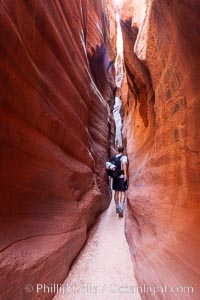
A hiker walking through the Wire Pass narrows. This exceedingly narrow slot canyon, in some places only two feet wide, is formed by water erosion which cuts slots deep into the surrounding sandstone plateau.
Location: Wire Pass, Paria Canyon-Vermilion Cliffs Wilderness, Arizona
Image ID: 20715
Location: Wire Pass, Paria Canyon-Vermilion Cliffs Wilderness, Arizona
Image ID: 20715
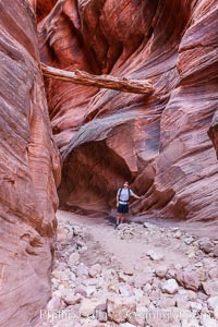
Suspended log in Buckskin Gulch. A hiker considers a heavy log stuck between the narrow walls of Buckskin Gulch, placed there by a flash flood some time in the past. Buckskin Gulch is the world's longest accessible slot canyon, forged by centuries of erosion through sandstone. Flash flooding is a serious danger in the narrows where there is no escape.
Location: Buckskin Gulch, Paria Canyon-Vermilion Cliffs Wilderness, Arizona
Image ID: 20717
Location: Buckskin Gulch, Paria Canyon-Vermilion Cliffs Wilderness, Arizona
Image ID: 20717
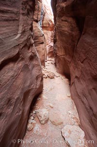
The Wire Pass narrows. This exceedingly narrow slot canyon, in some places only two feet wide, is formed by water erosion which cuts slots deep into the surrounding sandstone plateau.
Location: Wire Pass, Paria Canyon-Vermilion Cliffs Wilderness, Arizona
Image ID: 20720
Location: Wire Pass, Paria Canyon-Vermilion Cliffs Wilderness, Arizona
Image ID: 20720
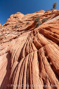
Sandstone formations. Layers of sandstone are revealed by erosion in the Wire Pass narrows.
Location: Wire Pass, Paria Canyon-Vermilion Cliffs Wilderness, Arizona
Image ID: 20731
Location: Wire Pass, Paria Canyon-Vermilion Cliffs Wilderness, Arizona
Image ID: 20731
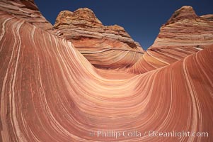
The Wave. The main corridor of the Wave, a famous and curiously shaped sandstone bowl.
Location: North Coyote Buttes, Paria Canyon-Vermilion Cliffs Wilderness, Arizona
Image ID: 20732
Location: North Coyote Buttes, Paria Canyon-Vermilion Cliffs Wilderness, Arizona
Image ID: 20732
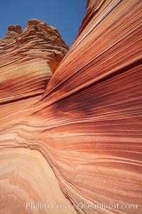
Sandstone striations. Prehistoric sand dunes, compressed into sandstone, are now revealed in sandstone layers subject to the carving erosive forces of wind and water.
Location: North Coyote Buttes, Paria Canyon-Vermilion Cliffs Wilderness, Arizona
Image ID: 20733
Location: North Coyote Buttes, Paria Canyon-Vermilion Cliffs Wilderness, Arizona
Image ID: 20733
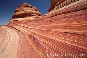
Sandstone striations. Prehistoric sand dunes, compressed into sandstone, are now revealed in sandstone layers subject to the carving erosive forces of wind and water.
Location: North Coyote Buttes, Paria Canyon-Vermilion Cliffs Wilderness, Arizona
Image ID: 20735
Location: North Coyote Buttes, Paria Canyon-Vermilion Cliffs Wilderness, Arizona
Image ID: 20735
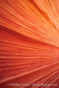
Sandstone striations. Prehistoric sand dunes, compressed into sandstone, are now revealed in sandstone layers subject to the carving erosive forces of wind and water.
Location: North Coyote Buttes, Paria Canyon-Vermilion Cliffs Wilderness, Arizona
Image ID: 20742
Location: North Coyote Buttes, Paria Canyon-Vermilion Cliffs Wilderness, Arizona
Image ID: 20742
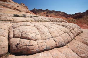
Sandstone joints. These cracks and joints are formed in the sandstone by water that seeps into spaces and is then frozen at night, expanding and cracking the sandstone into geometric forms.
Location: North Coyote Buttes, Paria Canyon-Vermilion Cliffs Wilderness, Arizona
Image ID: 20748
Location: North Coyote Buttes, Paria Canyon-Vermilion Cliffs Wilderness, Arizona
Image ID: 20748
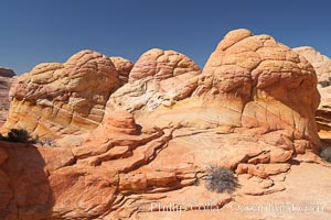
Brain rocks. Sandstone is curiously eroded through the forces water and wind acting over eons. Cracks and joints arise when water freezes and expands repeatedly, braking apart the soft sandstone.
Location: North Coyote Buttes, Paria Canyon-Vermilion Cliffs Wilderness, Arizona
Image ID: 20750
Location: North Coyote Buttes, Paria Canyon-Vermilion Cliffs Wilderness, Arizona
Image ID: 20750
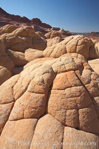
Brain rocks. Sandstone is curiously eroded through the forces water and wind acting over eons. Cracks and joints arise when water freezes and expands repeatedly, braking apart the soft sandstone.
Location: North Coyote Buttes, Paria Canyon-Vermilion Cliffs Wilderness, Arizona
Image ID: 20754
Location: North Coyote Buttes, Paria Canyon-Vermilion Cliffs Wilderness, Arizona
Image ID: 20754
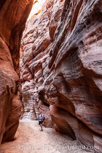
Hiker in Buckskin Gulch. A hiker considers the towering walls and narrow passageway of Buckskin Gulch, a dramatic slot canyon forged by centuries of erosion through sandstone. Buckskin Gulch is the worlds longest accessible slot canyon, running from the Paria River toward the Colorado River. Flash flooding is a serious danger in the narrows where there is no escape.
Location: Buckskin Gulch, Paria Canyon-Vermilion Cliffs Wilderness, Arizona
Image ID: 20772
Location: Buckskin Gulch, Paria Canyon-Vermilion Cliffs Wilderness, Arizona
Image ID: 20772
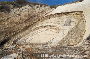
Shale is a fine-grained detrital sedimentary rock formed by the compaction of clay, silt, or mud. Shale is formed when mud is pressed into rock over millions of years and often breaks into big flat pieces. Here layers of shale emerge from the sand and cliffs at Gaviota State Beach north of Santa Barbara.
Location: Gaviota State Beach, Santa Barbara, California
Image ID: 14892
Location: Gaviota State Beach, Santa Barbara, California
Image ID: 14892
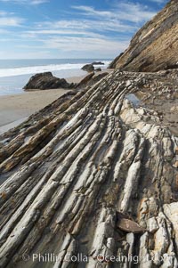
Shale is a fine-grained detrital sedimentary rock formed by the compaction of clay, silt, or mud. Shale is formed when mud is pressed into rock over millions of years and often breaks into big flat pieces. Here layers of shale emerge from the sand and cliffs at Gaviota State Beach north of Santa Barbara.
Location: Gaviota State Beach, Santa Barbara, California
Image ID: 14893
Location: Gaviota State Beach, Santa Barbara, California
Image ID: 14893
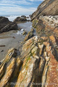
Shale is a fine-grained detrital sedimentary rock formed by the compaction of clay, silt, or mud. Shale is formed when mud is pressed into rock over millions of years and often breaks into big flat pieces. Here layers of shale emerge from the sand and cliffs at Gaviota State Beach north of Santa Barbara.
Location: Gaviota State Beach, Santa Barbara, California
Image ID: 14894
Location: Gaviota State Beach, Santa Barbara, California
Image ID: 14894
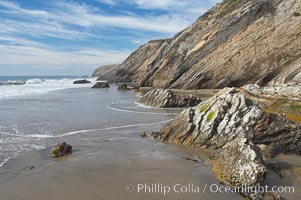
Shale is a fine-grained detrital sedimentary rock formed by the compaction of clay, silt, or mud. Shale is formed when mud is pressed into rock over millions of years and often breaks into big flat pieces. Here layers of shale emerge from the sand and cliffs at Gaviota State Beach north of Santa Barbara.
Location: Gaviota State Beach, Santa Barbara, California
Image ID: 14895
Location: Gaviota State Beach, Santa Barbara, California
Image ID: 14895
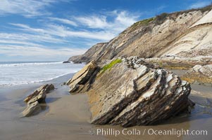
Shale is a fine-grained detrital sedimentary rock formed by the compaction of clay, silt, or mud. Shale is formed when mud is pressed into rock over millions of years and often breaks into big flat pieces. Here layers of shale emerge from the sand and cliffs at Gaviota State Beach north of Santa Barbara.
Location: Gaviota State Beach, Santa Barbara, California
Image ID: 14896
Location: Gaviota State Beach, Santa Barbara, California
Image ID: 14896
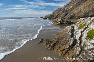
Shale is a fine-grained detrital sedimentary rock formed by the compaction of clay, silt, or mud. Shale is formed when mud is pressed into rock over millions of years and often breaks into big flat pieces. Here layers of shale emerge from the sand and cliffs at Gaviota State Beach north of Santa Barbara.
Location: Gaviota State Beach, Santa Barbara, California
Image ID: 14897
Location: Gaviota State Beach, Santa Barbara, California
Image ID: 14897
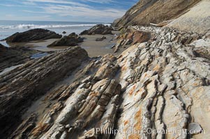
Shale is a fine-grained detrital sedimentary rock formed by the compaction of clay, silt, or mud. Shale is formed when mud is pressed into rock over millions of years and often breaks into big flat pieces. Here layers of shale emerge from the sand and cliffs at Gaviota State Beach north of Santa Barbara.
Location: Gaviota State Beach, Santa Barbara, California
Image ID: 14898
Location: Gaviota State Beach, Santa Barbara, California
Image ID: 14898
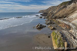
Shale is a fine-grained detrital sedimentary rock formed by the compaction of clay, silt, or mud. Shale is formed when mud is pressed into rock over millions of years and often breaks into big flat pieces. Here layers of shale emerge from the sand and cliffs at Gaviota State Beach north of Santa Barbara.
Location: Gaviota State Beach, Santa Barbara, California
Image ID: 14899
Location: Gaviota State Beach, Santa Barbara, California
Image ID: 14899
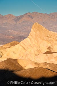
Zabriskie Point, sunrise. Manly Beacon rises in the center of an eroded, curiously banded area of sedimentary rock, with the Panamint Mountains visible in the distance.
Location: Zabriskie Point, Death Valley National Park, California
Image ID: 15586
Location: Zabriskie Point, Death Valley National Park, California
Image ID: 15586
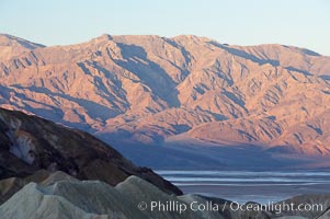
Zabriskie Point, sunrise. Curiously banded area of sedimentary rock lies in the foreground with the Panamint Mountains visible in the distance.
Location: Zabriskie Point, Death Valley National Park, California
Image ID: 15601
Location: Zabriskie Point, Death Valley National Park, California
Image ID: 15601
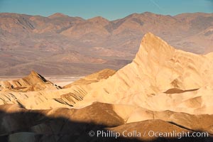
Zabriskie Point, sunrise. Manly Beacon rises in the center of an eroded, curiously banded area of sedimentary rock, with the Panamint Mountains visible in the distance.
Location: Zabriskie Point, Death Valley National Park, California
Image ID: 15602
Location: Zabriskie Point, Death Valley National Park, California
Image ID: 15602
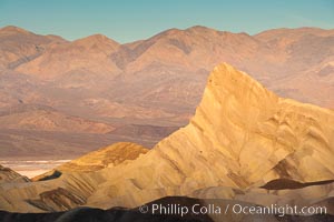
Zabriskie Point, sunrise. Manly Beacon rises in the center of an eroded, curiously banded area of sedimentary rock, with the Panamint Mountains visible in the distance.
Location: Zabriskie Point, Death Valley National Park, California
Image ID: 15618
Location: Zabriskie Point, Death Valley National Park, California
Image ID: 15618
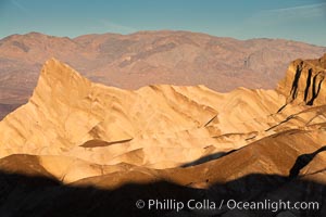
Zabriskie Point, sunrise. Manly Beacon rises in the center of an eroded, curiously banded area of sedimentary rock, with the Panamint Mountains visible in the distance.
Location: Zabriskie Point, Death Valley National Park, California
Image ID: 15619
Location: Zabriskie Point, Death Valley National Park, California
Image ID: 15619
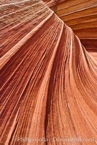
The Wave, an area of fantastic eroded sandstone featuring beautiful swirls, wild colors, countless striations, and bizarre shapes set amidst the dramatic surrounding North Coyote Buttes of Arizona and Utah. The sandstone formations of the North Coyote Buttes, including the Wave, date from the Jurassic period. Managed by the Bureau of Land Management, the Wave is located in the Paria Canyon-Vermilion Cliffs Wilderness and is accessible on foot by permit only.
Location: North Coyote Buttes, Paria Canyon-Vermilion Cliffs Wilderness, Arizona
Image ID: 20615
Location: North Coyote Buttes, Paria Canyon-Vermilion Cliffs Wilderness, Arizona
Image ID: 20615