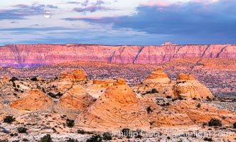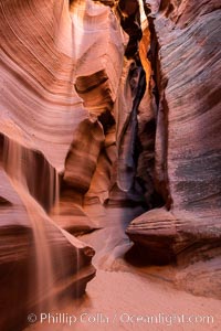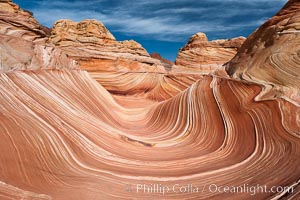
The Wave, an area of fantastic eroded sandstone featuring beautiful swirls, wild colors, countless striations, and bizarre shapes set amidst the dramatic surrounding North Coyote Buttes of Arizona and Utah. The sandstone formations of the North Coyote Buttes, including the Wave, date from the Jurassic period. Managed by the Bureau of Land Management, the Wave is located in the Paria Canyon-Vermilion Cliffs Wilderness and is accessible on foot by permit only.
Location: North Coyote Buttes, Paria Canyon-Vermilion Cliffs Wilderness, Arizona
Image ID: 20605
Location: North Coyote Buttes, Paria Canyon-Vermilion Cliffs Wilderness, Arizona
Image ID: 20605
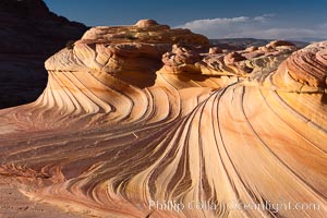
The Second Wave at Sunset, North Coyote Buttes. The Second Wave, a curiously-shaped sandstone swirl, takes on rich warm tones and dramatic shadowed textures at sunset. Set in the North Coyote Buttes of Arizona and Utah, the Second Wave is characterized by striations revealing layers of sedimentary deposits, a visible historical record depicting eons of submarine geology.
Location: North Coyote Buttes, Paria Canyon-Vermilion Cliffs Wilderness, Arizona
Image ID: 20606
Location: North Coyote Buttes, Paria Canyon-Vermilion Cliffs Wilderness, Arizona
Image ID: 20606
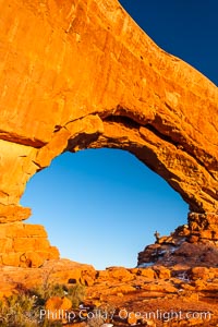
Hiker in North Window, sunset, western face. North Window is a natural sandstone arch 90 feet wide and 48 feet high.
Location: North Window, Arches National Park, Utah
Image ID: 18159
Location: North Window, Arches National Park, Utah
Image ID: 18159
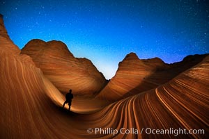
The Wave at Night, under a clear night sky full of stars. Photographer is illuminating the striated rocks with a small handheld light. The Wave, an area of fantastic eroded sandstone featuring beautiful swirls, wild colors, countless striations, and bizarre shapes is set amidst the dramatic surrounding North Coyote Buttes of Arizona and Utah. The sandstone formations of the North Coyote Buttes, including the Wave, date from the Jurassic period. Managed by the Bureau of Land Management, the Wave is located in the Paria Canyon-Vermilion Cliffs Wilderness and is accessible on foot by permit only.
Location: North Coyote Buttes, Paria Canyon-Vermilion Cliffs Wilderness, Arizona
Image ID: 28620
Location: North Coyote Buttes, Paria Canyon-Vermilion Cliffs Wilderness, Arizona
Image ID: 28620
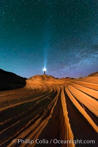
The Second Wave at Night. The Second Wave, a spectacular sandstone formation in the North Coyote Buttes, lies under a sky full of stars.
Location: North Coyote Buttes, Paria Canyon-Vermilion Cliffs Wilderness, Arizona
Image ID: 28627
Location: North Coyote Buttes, Paria Canyon-Vermilion Cliffs Wilderness, Arizona
Image ID: 28627
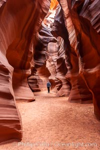
A hiker admiring the striated walls and dramatic light within Antelope Canyon, a deep narrow slot canyon formed by water and wind erosion.
Location: Navajo Tribal Lands, Page, Arizona
Image ID: 17993
Location: Navajo Tribal Lands, Page, Arizona
Image ID: 17993
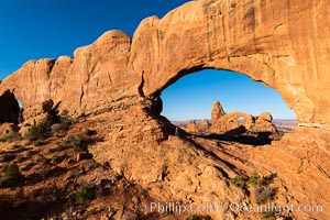
Tracy greets the dawn, with Turret Arch in the distance viewed through North Window at Sunrise.
Location: North Window, Arches National Park, Utah
Image ID: 37860
Location: North Window, Arches National Park, Utah
Image ID: 37860
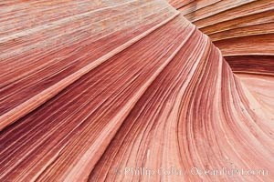
The Wave, an area of fantastic eroded sandstone featuring beautiful swirls, wild colors, countless striations, and bizarre shapes set amidst the dramatic surrounding North Coyote Buttes of Arizona and Utah. The sandstone formations of the North Coyote Buttes, including the Wave, date from the Jurassic period. Managed by the Bureau of Land Management, the Wave is located in the Paria Canyon-Vermilion Cliffs Wilderness and is accessible on foot by permit only.
Location: North Coyote Buttes, Paria Canyon-Vermilion Cliffs Wilderness, Arizona
Image ID: 20607
Location: North Coyote Buttes, Paria Canyon-Vermilion Cliffs Wilderness, Arizona
Image ID: 20607
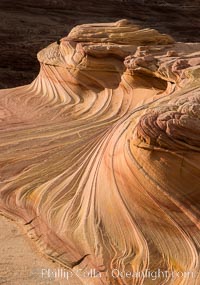
The Second Wave at Sunset, Vermillion Cliffs. The Second Wave, a curiously-shaped sandstone swirl, takes on rich warm tones and dramatic shadowed textures at sunset. Set in the North Coyote Buttes of Arizona and Utah, the Second Wave is characterized by striations revealing layers of sedimentary deposits, a visible historical record depicting eons of submarine geology.
Location: North Coyote Buttes, Paria Canyon-Vermilion Cliffs Wilderness, Arizona
Image ID: 28613
Location: North Coyote Buttes, Paria Canyon-Vermilion Cliffs Wilderness, Arizona
Image ID: 28613

Ancient Douglas fir trees in Cathedral Grove. Cathedral Grove is home to huge, ancient, old-growth Douglas fir trees. About 300 years ago a fire killed most of the trees in this grove, but a small number of trees survived and were the originators of what is now Cathedral Grove. Western redcedar trees grow in adundance in the understory below the taller Douglas fir trees.
Species: Douglas fir tree, Pseudotsuga menziesii
Location: Cathedral Grove, MacMillan Provincial Park, Vancouver Island, British Columbia, Canada
Image ID: 22456
Panorama dimensions: 9702 x 3043
Species: Douglas fir tree, Pseudotsuga menziesii
Location: Cathedral Grove, MacMillan Provincial Park, Vancouver Island, British Columbia, Canada
Image ID: 22456
Panorama dimensions: 9702 x 3043
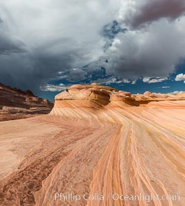
The Second Wave at sunset. The Second Wave, a curiously-shaped sandstone swirl, takes on rich warm tones and dramatic shadowed textures at sunset. Set in the North Coyote Buttes of Arizona and Utah, the Second Wave is characterized by striations revealing layers of sedimentary deposits, a visible historical record depicting eons of submarine geology.
Location: North Coyote Buttes, Paria Canyon-Vermilion Cliffs Wilderness, Arizona
Image ID: 28614
Location: North Coyote Buttes, Paria Canyon-Vermilion Cliffs Wilderness, Arizona
Image ID: 28614
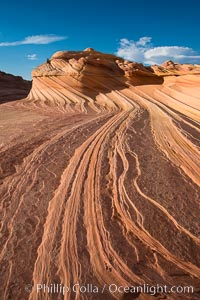
The Second Wave at Sunset, Vermillion Cliffs. The Second Wave, a curiously-shaped sandstone swirl, takes on rich warm tones and dramatic shadowed textures at sunset. Set in the North Coyote Buttes of Arizona and Utah, the Second Wave is characterized by striations revealing layers of sedimentary deposits, a visible historical record depicting eons of submarine geology.
Location: North Coyote Buttes, Paria Canyon-Vermilion Cliffs Wilderness, Arizona
Image ID: 28619
Location: North Coyote Buttes, Paria Canyon-Vermilion Cliffs Wilderness, Arizona
Image ID: 28619
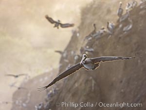
Brown Pelicans Flying Along Sheer Ocean Cliffs, rare westerly winds associated with a storm allow pelicans to glide along La Jolla's cliffs as they approach shelves and outcroppings on which to land. Backlit by rising sun during stormy conditions.
Species: Brown Pelican, Pelecanus occidentalis, Pelecanus occidentalis californicus
Location: La Jolla, California
Image ID: 38867
Species: Brown Pelican, Pelecanus occidentalis, Pelecanus occidentalis californicus
Location: La Jolla, California
Image ID: 38867
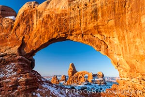
Turret Arch through North Window, winter, sunrise.
Location: North Window, Arches National Park, Utah
Image ID: 18120
Location: North Window, Arches National Park, Utah
Image ID: 18120
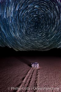
Racetrack sailing stone and star trails. A sliding rock of the Racetrack Playa. The sliding rocks, or sailing stones, move across the mud flats of the Racetrack Playa, leaving trails behind in the mud. The explanation for their movement is not known with certainty, but many believe wind pushes the rocks over wet and perhaps icy mud in winter.
Location: Racetrack Playa, Death Valley National Park, California
Image ID: 27671
Location: Racetrack Playa, Death Valley National Park, California
Image ID: 27671
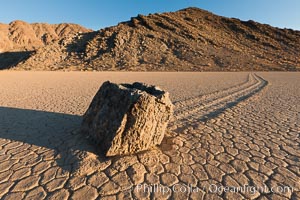
Sailing stone on the Racetrack Playa. The sliding rocks, or sailing stones, move across the mud flats of the Racetrack Playa, leaving trails behind in the mud. The explanation for their movement is not known with certainty, but many believe wind pushes the rocks over wet and perhaps icy mud in winter.
Location: Racetrack Playa, Death Valley National Park, California
Image ID: 27689
Location: Racetrack Playa, Death Valley National Park, California
Image ID: 27689

Sunset at Dead Horse Point Overlook, with the Colorado River flowing 2,000 feet below. 300 million years of erosion has carved the expansive canyons, cliffs and walls below and surrounding Deadhorse Point.
Location: Dead Horse Point State Park, Utah
Image ID: 27823
Panorama dimensions: 5303 x 17695
Location: Dead Horse Point State Park, Utah
Image ID: 27823
Panorama dimensions: 5303 x 17695
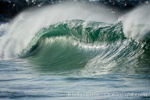
A large, powerful wave breaks with offshore winds at the Wedge in Newport Beach.
Location: The Wedge, Newport Beach, California
Image ID: 18706
Location: The Wedge, Newport Beach, California
Image ID: 18706
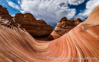
The Wave in the North Coyote Buttes, an area of fantastic eroded sandstone featuring beautiful swirls, wild colors, countless striations, and bizarre shapes set amidst the dramatic surrounding North Coyote Buttes of Arizona and Utah. The sandstone formations of the North Coyote Buttes, including the Wave, date from the Jurassic period. Managed by the Bureau of Land Management, the Wave is located in the Paria Canyon-Vermilion Cliffs Wilderness and is accessible on foot by permit only.
Location: North Coyote Buttes, Paria Canyon-Vermilion Cliffs Wilderness, Arizona
Image ID: 28601
Location: North Coyote Buttes, Paria Canyon-Vermilion Cliffs Wilderness, Arizona
Image ID: 28601
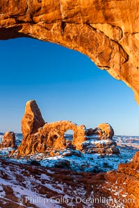
Sunrise light on Turret Arch viewed through North Window, winter.
Location: North Window, Arches National Park, Utah
Image ID: 18119
Location: North Window, Arches National Park, Utah
Image ID: 18119
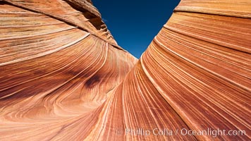
The Wave, an area of fantastic eroded sandstone featuring beautiful swirls, wild colors, countless striations, and bizarre shapes set amidst the dramatic surrounding North Coyote Buttes of Arizona and Utah. The sandstone formations of the North Coyote Buttes, including the Wave, date from the Jurassic period. Managed by the Bureau of Land Management, the Wave is located in the Paria Canyon-Vermilion Cliffs Wilderness and is accessible on foot by permit only.
Location: North Coyote Buttes, Paria Canyon-Vermilion Cliffs Wilderness, Arizona
Image ID: 20608
Location: North Coyote Buttes, Paria Canyon-Vermilion Cliffs Wilderness, Arizona
Image ID: 20608
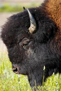
The bisons massive head is its most characteristic feature. Its forehead bulges because of its convex-shaped frontal bone. Its shoulder hump, dwindling bowlike to the haunches, is supported by unusually long spinal vertebrae. Over powerful neck and shoulder muscles grows a great shaggy coat of curly brown fur, and over the head, like an immense hood, grows a shock of black hair. Its forequarters are higher and much heavier than its haunches. A mature bull stands about 6 1/2 feet (2 meters) at the shoulder and weighs more than 2,000 pounds (900 kilograms). The bisons horns are short and black. In the male they are thick at the base and taper abruptly to sharp points as they curve outward and upward; the females horns are more slender.
Species: American bison, Bison bison
Location: Yellowstone National Park, Wyoming
Image ID: 13120
Species: American bison, Bison bison
Location: Yellowstone National Park, Wyoming
Image ID: 13120
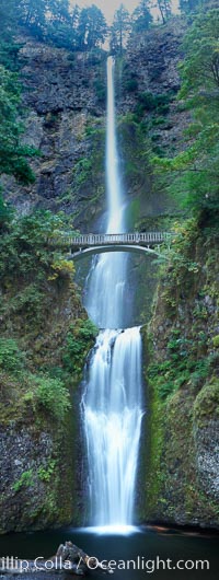
Multnomah Falls. Plummeting 620 feet from its origins on Larch Mountain, Multnomah Falls is the second highest year-round waterfall in the United States. Nearly two million visitors a year come to see this ancient waterfall making it Oregon's number one public destination.
Location: Multnomah Falls, Columbia River Gorge National Scenic Area, Oregon
Image ID: 19313
Panorama dimensions: 12453 x 4705
Location: Multnomah Falls, Columbia River Gorge National Scenic Area, Oregon
Image ID: 19313
Panorama dimensions: 12453 x 4705

Panorama of the Wave. The Wave is a sweeping, dramatic display of eroded sandstone, forged by eons of water and wind erosion, laying bare striations formed from compacted sand dunes over millenia. This panoramic picture is formed from thirteen individual photographs.
Location: North Coyote Buttes, Paria Canyon-Vermilion Cliffs Wilderness, Arizona
Image ID: 20700
Panorama dimensions: 4661 x 25458
Location: North Coyote Buttes, Paria Canyon-Vermilion Cliffs Wilderness, Arizona
Image ID: 20700
Panorama dimensions: 4661 x 25458
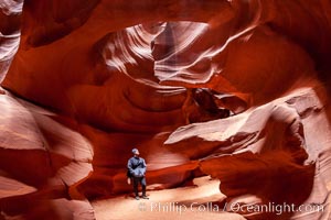
A hiker admiring the striated walls and dramatic light within Antelope Canyon, a deep narrow slot canyon formed by water and wind erosion.
Location: Navajo Tribal Lands, Page, Arizona
Image ID: 18009
Location: Navajo Tribal Lands, Page, Arizona
Image ID: 18009
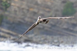
Brown Pelican Flying Along Sheer Ocean Cliffs, rare westerly winds associated with a storm allow pelicans to glide along La Jolla's cliffs as they approach shelves and outcroppings on which to land. Backlit by rising sun during stormy conditions.
Species: Brown Pelican, Pelecanus occidentalis, Pelecanus occidentalis californicus
Location: La Jolla, California
Image ID: 38871
Species: Brown Pelican, Pelecanus occidentalis, Pelecanus occidentalis californicus
Location: La Jolla, California
Image ID: 38871
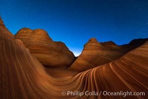
The Wave at Night, under a clear night sky full of stars. The Wave, an area of fantastic eroded sandstone featuring beautiful swirls, wild colors, countless striations, and bizarre shapes set amidst the dramatic surrounding North Coyote Buttes of Arizona and Utah. The sandstone formations of the North Coyote Buttes, including the Wave, date from the Jurassic period. Managed by the Bureau of Land Management, the Wave is located in the Paria Canyon-Vermilion Cliffs Wilderness and is accessible on foot by permit only.
Location: North Coyote Buttes, Paria Canyon-Vermilion Cliffs Wilderness, Arizona
Image ID: 28621
Location: North Coyote Buttes, Paria Canyon-Vermilion Cliffs Wilderness, Arizona
Image ID: 28621
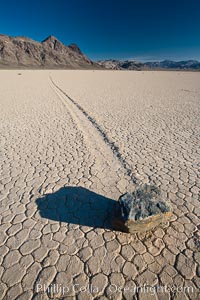
A sliding rock of the Racetrack Playa. The sliding rocks, or sailing stones, move across the mud flats of the Racetrack Playa, leaving trails behind in the mud. The explanation for their movement is not known with certainty, but many believe wind pushes the rocks over wet and perhaps icy mud in winter.
Location: Racetrack Playa, Death Valley National Park, California
Image ID: 25239
Location: Racetrack Playa, Death Valley National Park, California
Image ID: 25239
