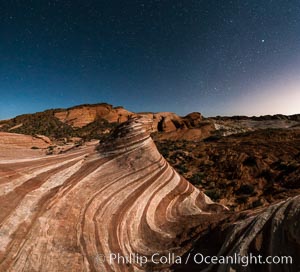
The Fire Wave by Moonlight, stars and the night sky, Valley of Fire State Park.
Location: Valley of Fire State Park, Nevada
Image ID: 28442
Panorama dimensions: 6250 x 6887
Location: Valley of Fire State Park, Nevada
Image ID: 28442
Panorama dimensions: 6250 x 6887
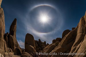
Full moon with 22-degree lunar halo, Joshua Tree National Park. The lunar halo (not to be cofused with lunar corona) forms when moonlight refracts through high altitude ice crystals. As no light is refracted at angles smaller than 22-degrees the sky is darker inside the halo.
Location: Joshua Tree National Park, California
Image ID: 30711
Location: Joshua Tree National Park, California
Image ID: 30711
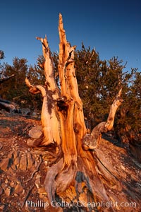
Ancient bristlecone pine tree, rising above the arid, dolomite-rich slopes of the Schulman Grove in the White Mountains at an elevation of 9500 above sea level, along the Methuselah Walk. The oldest bristlecone pines in the world are found in the Schulman Grove, some of them over 4700 years old. Ancient Bristlecone Pine Forest.
Species: Bristlecone pine, Pinus longaeva
Location: White Mountains, Inyo National Forest, California
Image ID: 23233
Species: Bristlecone pine, Pinus longaeva
Location: White Mountains, Inyo National Forest, California
Image ID: 23233
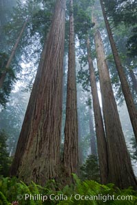
Giant redwood, Lady Bird Johnson Grove, Redwood National Park. The coastal redwood, or simply 'redwood', is the tallest tree on Earth, reaching a height of 379' and living 3500 years or more. It is native to coastal California and the southwestern corner of Oregon within the United States, but most concentrated in Redwood National and State Parks in Northern California, found close to the coast where moisture and soil conditions can support its unique size and growth requirements.
Species: California redwood, Coast redwood, Giant redwood, Sequoia sempervirens
Location: Redwood National Park, California
Image ID: 25795
Species: California redwood, Coast redwood, Giant redwood, Sequoia sempervirens
Location: Redwood National Park, California
Image ID: 25795
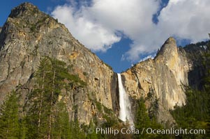
Bridalveil Falls at sunset, with clouds and blue sky in the background. Bridalveil Falls in Yosemite drops 620 feet (188 m) from a hanging valley to the floor of Yosemite Valley.
Location: Bridalveil Falls, Yosemite National Park, California
Image ID: 12646
Location: Bridalveil Falls, Yosemite National Park, California
Image ID: 12646
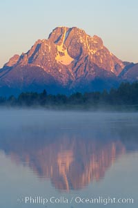
Mount Moran rises above the Snake River at Oxbow Bend at sunrise.
Location: Oxbow Bend, Grand Teton National Park, Wyoming
Image ID: 13026
Location: Oxbow Bend, Grand Teton National Park, Wyoming
Image ID: 13026
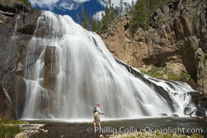
Fly fishing below Gibbon Falls. This flyfisherman hiked up the Gibbon River to reach the foot of Gibbon Falls.
Location: Gibbon River, Yellowstone National Park, Wyoming
Image ID: 13269
Location: Gibbon River, Yellowstone National Park, Wyoming
Image ID: 13269
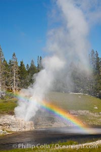
A rainbow appears in the spray of Riverside Geyser as it erupts over the Firehole River. Riverside is a very predictable geyser. Its eruptions last 30 minutes, reach heights of 75 feet and are usually spaced about 6 hours apart. Upper Geyser Basin.
Location: Upper Geyser Basin, Yellowstone National Park, Wyoming
Image ID: 13367
Location: Upper Geyser Basin, Yellowstone National Park, Wyoming
Image ID: 13367
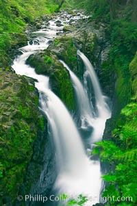
Sol Duc Falls. Sol Duc Falls is one of the largest and most beautiful waterfalls in Olympic National Park, seen here from a bridge that crosses the canyon just below the falls. Surrounding the falls is an old-growth forest of hemlocks and douglas firs, some of which are three hundred years in age.
Location: Sol Duc Springs, Olympic National Park, Washington
Image ID: 13747
Location: Sol Duc Springs, Olympic National Park, Washington
Image ID: 13747
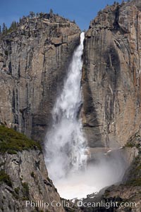
Upper Yosemite Falls near peak flow in spring. Yosemite Falls, at 2425 feet tall (730m) is the tallest waterfall in North America and fifth tallest in the world. Yosemite Valley.
Location: Yosemite Falls, Yosemite National Park, California
Image ID: 16066
Location: Yosemite Falls, Yosemite National Park, California
Image ID: 16066
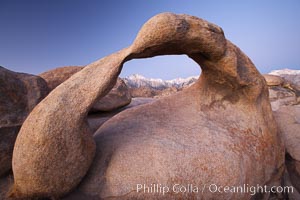
Mobius Arch at sunrise, with Mount Whitney (the tallest peak in the continental United States), Lone Pine Peak and snow-covered Sierra Nevada Range framed within the arch. Mobius Arch is a 17-foot-wide natural rock arch in the scenic Alabama Hills Recreational Area near Lone Pine, California.
Location: Alabama Hills Recreational Area, California
Image ID: 21729
Location: Alabama Hills Recreational Area, California
Image ID: 21729
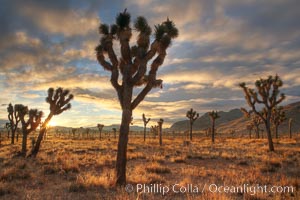
Sunrise in Joshua Tree National Park.
Species: Joshua tree, Yucca brevifolia
Location: Joshua Tree National Park, California
Image ID: 22100
Species: Joshua tree, Yucca brevifolia
Location: Joshua Tree National Park, California
Image ID: 22100
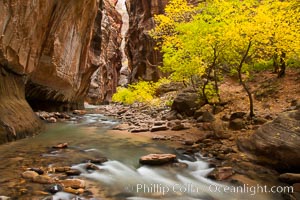
The Virgin River flows by autumn cottonwood trees, part of the Virgin River Narrows. This is a fantastic hike in fall with the comfortable temperatures, beautiful fall colors and light crowds.
Location: Virgin River Narrows, Zion National Park, Utah
Image ID: 26098
Location: Virgin River Narrows, Zion National Park, Utah
Image ID: 26098
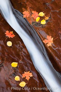
Water rushes through a narrow crack, in the red sandstone of Zion National Park, with fallen autumn leaves.
Location: Zion National Park, Utah
Image ID: 26100
Location: Zion National Park, Utah
Image ID: 26100
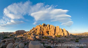
Sunset and boulders, Joshua Tree National Park. Sunset lights the giant boulders and rock formations near Jumbo Rocks in Joshua Tree N.P.
Location: Joshua Tree National Park, California
Image ID: 26719
Panorama dimensions: 5493 x 10035
Location: Joshua Tree National Park, California
Image ID: 26719
Panorama dimensions: 5493 x 10035
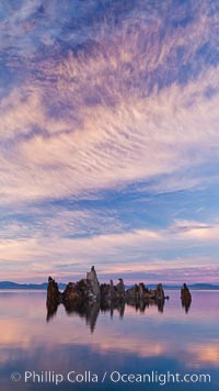
Mono Lake sunset, tufa and clouds reflected in the still waters of Mono Lake.
Location: Mono Lake, California
Image ID: 26977
Location: Mono Lake, California
Image ID: 26977
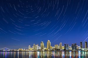
Star Trails over the San Diego Downtown City Skyline. In this 60 minute exposure, stars create trails through the night sky over downtown San Diego.
Location: San Diego, California
Image ID: 28383
Location: San Diego, California
Image ID: 28383

Three Sisters Springs depicted in an underwater landscape with sand, clear water and trees.
Location: Three Sisters Springs, Crystal River, Florida
Image ID: 02673
Location: Three Sisters Springs, Crystal River, Florida
Image ID: 02673
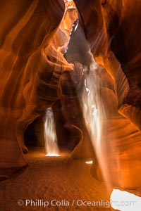
Light Beam in Upper Antelope Slot Canyon. Thin shafts of light briefly penetrate the convoluted narrows of Upper Antelope Slot Canyon, sending piercing beams through the sandstone maze to the sand floor below.
Location: Navajo Tribal Lands, Page, Arizona
Image ID: 28561
Location: Navajo Tribal Lands, Page, Arizona
Image ID: 28561
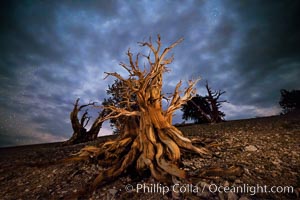
Ancient Bristlecone Pine Tree at night, stars and the Milky Way galaxy visible in the evening sky, near Patriarch Grove.
Species: Ancient bristlecone pine, Pinus longaeva
Location: Ancient Bristlecone Pine Forest, White Mountains, Inyo National Forest, California
Image ID: 28786
Species: Ancient bristlecone pine, Pinus longaeva
Location: Ancient Bristlecone Pine Forest, White Mountains, Inyo National Forest, California
Image ID: 28786
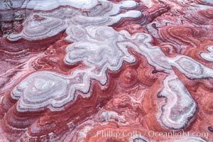
Fantastic colorful sedimentary patterns of Bentonite layers, seen as striations exposed in the Utah Badlands. The Bentonite Hills are composed of the Brushy Basin shale member of the Morrison Formation formed during Jurassic times when mud, silt, fine sand, and volcanic ash were deposited in swamps and lakes into layers, now revealed through erosion. Aerial photograph.
Location: Utah
Image ID: 37947
Location: Utah
Image ID: 37947
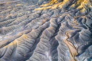
Erosion patterns in the Utah Badlands, aerial abstract photo.
Location: Hanksville, Utah
Image ID: 37948
Location: Hanksville, Utah
Image ID: 37948
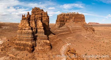
Molly's Castle, aerial view, Goblin Valley State Park. Curtis Formation whiteish caprock is on top, with reddish Entrada Sandstone below, both of Jurassic era. Molly's castle lies in the San Rafael desert near Goblin Valley, and drains into the Colorado River watershed. Aerial panoramic photograph.
Location: Goblin Valley State Park, Utah
Image ID: 37950
Location: Goblin Valley State Park, Utah
Image ID: 37950
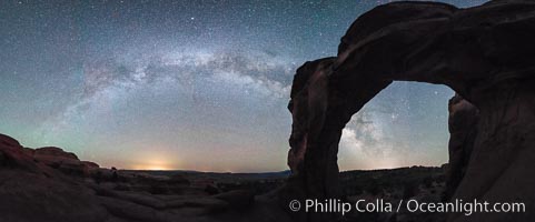
Milky Way and Stars over Broken Arch, Arches National Park, Utah.
Location: Broken Arch, Arches National Park, Utah
Image ID: 29237
Panorama dimensions: 5882 x 15117
Location: Broken Arch, Arches National Park, Utah
Image ID: 29237
Panorama dimensions: 5882 x 15117
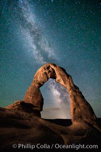
Milky Way arches over Delicate Arch, as stars cover the night sky.
Location: Arches National Park, Utah
Image ID: 27850
Location: Arches National Park, Utah
Image ID: 27850
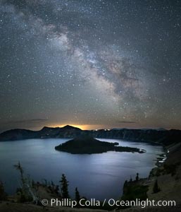
Milky Way and stars over Crater Lake at night. Panorama of Crater Lake and Wizard Island at night, Crater Lake National Park.
Location: Crater Lake National Park, Oregon
Image ID: 28643
Location: Crater Lake National Park, Oregon
Image ID: 28643
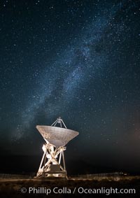
Radio telescope antenna, part of the Very Long Baseline Array (VLBA). The Very Long Baseline Array (VLBA) is a system of ten radio telescopes which are operated remotely from their Array Operations Center located in Socorro, New Mexico, as a part of the National Radio Astronomy Observatory (NRAO). These ten radio antennas work together as an array that forms the longest system in the world that uses very long baseline interferometry.
Location: Big Pine, California
Image ID: 28787
Location: Big Pine, California
Image ID: 28787
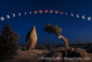
Lunar Eclipse and blood red moon sequence, over Juniper and Standing Rock, composite image, Joshua Tree National Park, April 14/15 2014.
Image ID: 29204
Image ID: 29204
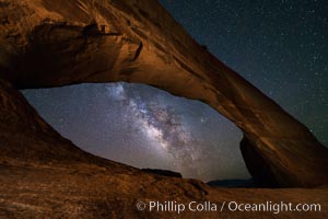
Milky Way and Stars through Wilson Arch. Wilson Arch rises high above route 191 in eastern Utah, with a span of 91 feet and a height of 46 feet.
Location: Wilson Arch, Moab, Utah
Image ID: 29275
Location: Wilson Arch, Moab, Utah
Image ID: 29275
