
Jardin du Luxembourg. The Jardin du Luxembourg, or the Luxembourg Gardens, is the second largest public park in Paris located in the 6th arrondissement of Paris, France. The park is the garden of the French Senate, which is itself housed in the Luxembourg Palace.
Location: Jardin du Luxembourg, Paris, France
Image ID: 28180
Panorama dimensions: 3699 x 18309
Location: Jardin du Luxembourg, Paris, France
Image ID: 28180
Panorama dimensions: 3699 x 18309
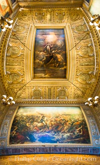
The Battle of the Nile, also known as the Battle of Aboukir Bay, in French as the Bataille d'Aboukir, panaramic photo showing wall and ceiling detail.
Location: Chateau de Versailles, Paris, France
Image ID: 28076
Panorama dimensions: 10378 x 6332
Location: Chateau de Versailles, Paris, France
Image ID: 28076
Panorama dimensions: 10378 x 6332
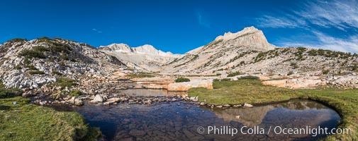
First View of Conness Lakes Basin with Mount Conness (12589' center) and North Peak (12242', right), Hoover Wilderness.
Location: Conness Lakes Basin, Hoover Wilderness, California
Image ID: 31057
Panorama dimensions: 5623 x 14211
Location: Conness Lakes Basin, Hoover Wilderness, California
Image ID: 31057
Panorama dimensions: 5623 x 14211

Guadalupe Island at sunrise, panorama. Volcanic coastline south of Pilot Rock and Spanish Cove, near El Faro lighthouse.
Location: Guadalupe Island (Isla Guadalupe), Baja California, Mexico
Image ID: 19497
Panorama dimensions: 2797 x 16157
Location: Guadalupe Island (Isla Guadalupe), Baja California, Mexico
Image ID: 19497
Panorama dimensions: 2797 x 16157

Ile Saint-Louis, is one of two natural islands in the Seine river, in Paris, France. The island is named after King Louis IX of France (Saint Louis). The island is connected to the rest of Paris by bridges to both banks of the river and by the Pont Saint Louis to the Ile de la Cite.
Location: Ile Saint-Louis, Paris, France
Image ID: 28189
Panorama dimensions: 3437 x 12063
Location: Ile Saint-Louis, Paris, France
Image ID: 28189
Panorama dimensions: 3437 x 12063
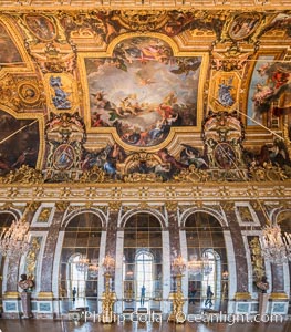
The Hall of Mirrors, or Galerie des Glaces, is the central gallery of the Palace of Versailles and is renowned as being one of the most famous rooms in the world.
Location: Chateau de Versailles, Paris, France
Image ID: 28073
Panorama dimensions: 6748 x 5927
Location: Chateau de Versailles, Paris, France
Image ID: 28073
Panorama dimensions: 6748 x 5927
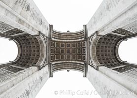
Arc de Triomphe. The Arc de Triomphe (Arc de Triomphe de l'Etoile) is one of the most famous monuments in Paris. It stands in the centre of the Place Charles de Gaulle (originally named Place de l'Etoile), at the western end of the Champs-Elysees. The Arc de Triomphe (in English: "Triumphal Arch") honors those who fought and died for France in the French Revolutionary and the Napoleonic Wars, with the names of all French victories and generals inscribed on its inner and outer surfaces. Beneath its vault lies the Tomb of the Unknown Soldier from World War I. The monument was designed by Jean Chalgrin in 1806, and its iconographic program pitted heroically nude French youths against bearded Germanic warriors in chain mail. It set the tone for public monuments, with triumphant patriotic messages. The monument stands 50 metres (164 ft) in height, 45 m (148 ft) wide and 22 m (72 ft) deep.
Location: Arc de Triomphe, Paris, France
Image ID: 28080
Panorama dimensions: 7793 x 10813
Location: Arc de Triomphe, Paris, France
Image ID: 28080
Panorama dimensions: 7793 x 10813

Dusk settles on downtown San Diego with snow-covered Mt. Laguna in the distance.
Location: San Diego, California
Image ID: 26717
Panorama dimensions: 4968 x 17484
Location: San Diego, California
Image ID: 26717
Panorama dimensions: 4968 x 17484

Buckskin Gulch hiker. A hiker moves through the deep narrow passages of Buckskin Gulch, a slot canyon cut deep into sandstone by years of river-induced erosion. In some places the Buckskin Gulch narrows are only about 15 feet wide but several hundred feet high, blocking sunlight. Flash floods are dangerous as there is no escape once into the Buckskin Gulch slot canyons. This is a panorama made of sixteen individual photos.
Location: Buckskin Gulch, Paria Canyon-Vermilion Cliffs Wilderness, Arizona
Image ID: 20699
Panorama dimensions: 4771 x 15311
Location: Buckskin Gulch, Paria Canyon-Vermilion Cliffs Wilderness, Arizona
Image ID: 20699
Panorama dimensions: 4771 x 15311
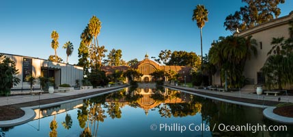
The Botanical Building in Balboa Park, San Diego. The Botanical Building, at 250 feet long by 75 feet wide and 60 feet tall, was the largest wood lath structure in the world when it was built in 1915 for the Panama-California Exposition. The Botanical Building, located on the Prado, west of the Museum of Art, contains about 2,100 permanent tropical plants along with changing seasonal flowers. The Lily Pond, just south of the Botanical Building, is an eloquent example of the use of reflecting pools to enhance architecture. The 193' by 43' foot pond and smaller companion pool were originally referred to as Las Lagunas de las Flores (The Lakes of the Flowers) and were designed as aquatic gardens. The pools contain exotic water lilies and lotus which bloom spring through fall.
Location: Balboa Park, San Diego, California
Image ID: 28826
Panorama dimensions: 5475 x 11746
Location: Balboa Park, San Diego, California
Image ID: 28826
Panorama dimensions: 5475 x 11746
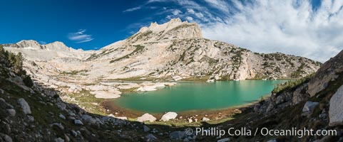
North Peak (12242', center), Mount Conness (left, 12589') and Conness Lake with its green glacial meltwater, Hoover Wilderness.
Location: Conness Lakes Basin, Hoover Wilderness, California
Image ID: 31060
Panorama dimensions: 6685 x 16072
Location: Conness Lakes Basin, Hoover Wilderness, California
Image ID: 31060
Panorama dimensions: 6685 x 16072
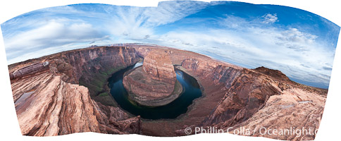
Horseshoe Bend. The Colorado River makes a 180-degree turn at Horseshoe Bend. Here the river has eroded the Navajo sandstone for eons, digging a canyon 1100-feet deep.
Location: Horseshoe Bend, Page, Arizona
Image ID: 26618
Panorama dimensions: 4625 x 9801
Location: Horseshoe Bend, Page, Arizona
Image ID: 26618
Panorama dimensions: 4625 x 9801

Adelie penguin colony, panoramic photograph.
Species: Adelie penguin, Pygoscelis adeliae
Location: Devil Island, Antarctic Peninsula, Antarctica
Image ID: 26314
Panorama dimensions: 3463 x 13408
Species: Adelie penguin, Pygoscelis adeliae
Location: Devil Island, Antarctic Peninsula, Antarctica
Image ID: 26314
Panorama dimensions: 3463 x 13408

Fort Rosecrans National Cemetery.
Location: San Diego, California
Image ID: 26588
Panorama dimensions: 4842 x 16071
Location: San Diego, California
Image ID: 26588
Panorama dimensions: 4842 x 16071
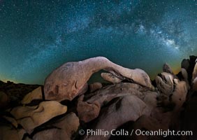
The Milky Way galaxy arches over Arch Rock on a clear evening in Joshua Tree National Park.
Location: Joshua Tree National Park, California
Image ID: 26796
Panorama dimensions: 5381 x 7597
Location: Joshua Tree National Park, California
Image ID: 26796
Panorama dimensions: 5381 x 7597

Isla Partida, Sea of Cortez coastal scenic panorama, near La Paz, Baja California, Mexico, part of the Espiritu Santo Biosphere Reserve.
Location: Sea of Cortez, Baja California, Mexico
Image ID: 27358
Panorama dimensions: 5197 x 20384
Location: Sea of Cortez, Baja California, Mexico
Image ID: 27358
Panorama dimensions: 5197 x 20384
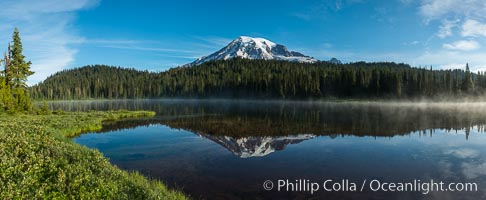
Mount Rainier is reflected in the calm waters of Reflection Lake, early morning.
Location: Reflection Lake, Mount Rainier National Park, Washington
Image ID: 28706
Panorama dimensions: 5517 x 13404
Location: Reflection Lake, Mount Rainier National Park, Washington
Image ID: 28706
Panorama dimensions: 5517 x 13404

The Tatoosh Range viewed from the Skyline Trail, above Paradise Meadows on southern flank of Mount Rainier.
Location: Mount Rainier National Park, Washington
Image ID: 28713
Panorama dimensions: 4692 x 17709
Location: Mount Rainier National Park, Washington
Image ID: 28713
Panorama dimensions: 4692 x 17709

Panoramic photo of Santa Barbara Island, part of the Channel Islands National Marine Sanctuary. Santa Barbara Island lies 38 miles offshore of the coast of California, near Los Angeles and San Pedro. California sea lions inhabit the island in the thousands, and can be seen hauled out on the shore in this image.
Location: Santa Barbara Island, California
Image ID: 23598
Panorama dimensions: 2759 x 18816
Location: Santa Barbara Island, California
Image ID: 23598
Panorama dimensions: 2759 x 18816

Panoramic photo of San Clemente Island, southern end from China Hat Point (aka, Balanced Rock, right) along the length of Pyramid Cove, sunrise.
Location: San Clemente Island, California
Image ID: 23599
Panorama dimensions: 2629 x 26293
Location: San Clemente Island, California
Image ID: 23599
Panorama dimensions: 2629 x 26293

Oceanside Pier panorama.
Location: Oceanside Pier, California
Image ID: 19519
Panorama dimensions: 2422 x 16951
Location: Oceanside Pier, California
Image ID: 19519
Panorama dimensions: 2422 x 16951
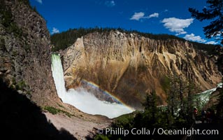
Panorama of Yellowstone Falls from Uncle Tom's Trail. Lower Yellowstone Falls shows a beautiful rainbow as it cascades 308' in a thundering plunge into the Grand Canyon of the Yellowstone River.
Location: Grand Canyon of the Yellowstone, Yellowstone National Park, Wyoming
Image ID: 26957
Panorama dimensions: 6064 x 9671
Location: Grand Canyon of the Yellowstone, Yellowstone National Park, Wyoming
Image ID: 26957
Panorama dimensions: 6064 x 9671
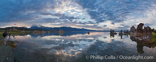
Mono Lake sunset, Sierra Nevada mountain range and tufas, clouds reflected in the still waters of Mono Lake.
Location: Mono Lake, California
Image ID: 26967
Panorama dimensions: 4835 x 12178
Location: Mono Lake, California
Image ID: 26967
Panorama dimensions: 4835 x 12178

Panorama of the Minarets at sunrise, near Mammoth Mountain. The Minarets are a series of seventeen jagged peaks in the Ritter Range, west of Mammoth Mountain in the Ansel Adams Wilderness. These basalt peaks were carved by glaciers on both sides of the range. The highest of the Minarets stands 12,281 feet above sea level.
Location: Mammoth Lakes, California
Image ID: 19123
Panorama dimensions: 3233 x 26731
Location: Mammoth Lakes, California
Image ID: 19123
Panorama dimensions: 3233 x 26731

Panoramic view of the Columbia River as it flows through Columbia River Gorge Scenic Area, looking east from the Vista House overlook on the southern Oregon side of the river.
Location: Columbia River, Columbia River Gorge National Scenic Area, Oregon
Image ID: 19374
Panorama dimensions: 3125 x 21408
Location: Columbia River, Columbia River Gorge National Scenic Area, Oregon
Image ID: 19374
Panorama dimensions: 3125 x 21408

The North Head Lighthouse was built in 1896. 69 steps lead to the lantern room, which is 65 feet from the ground and 194 feet above sea level. The first-order Fresnel lens, which came from Cape Disappointment, was lit for the first time on May 16, 1898.
Location: Washington
Image ID: 19390
Panorama dimensions: 4757 x 20503
Location: Washington
Image ID: 19390
Panorama dimensions: 4757 x 20503

Lunar eclipse sequence, showing total eclipse (left) through full moon (right). While the moon lies in the full shadow of the earth (umbra) it receives only faint, red-tinged light refracted through the Earth's atmosphere. As the moon passes into the penumbra it receives increasing amounts of direct sunlight, eventually leaving the shadow of the Earth altogether. August 28, 2007.
Location: Earth Orbit, Solar System, Milky Way Galaxy, The Universe
Image ID: 19392
Panorama dimensions: 1835 x 6442
Location: Earth Orbit, Solar System, Milky Way Galaxy, The Universe
Image ID: 19392
Panorama dimensions: 1835 x 6442

Monument Valley panorama.
Location: Monument Valley, Arizona
Image ID: 19531
Panorama dimensions: 3241 x 28803
Location: Monument Valley, Arizona
Image ID: 19531
Panorama dimensions: 3241 x 28803

Panorama of Devil Island in Antarctica.
Location: Devil Island, Antarctic Peninsula, Antarctica
Image ID: 26302
Panorama dimensions: 2814 x 27072
Location: Devil Island, Antarctic Peninsula, Antarctica
Image ID: 26302
Panorama dimensions: 2814 x 27072

Grand Canyon of the Yellowstone, panorama, from Lookout Point, winter, a composite of 7 individual photographs.
Location: Grand Canyon of the Yellowstone, Yellowstone National Park, Wyoming
Image ID: 22451
Panorama dimensions: 2030 x 12763
Location: Grand Canyon of the Yellowstone, Yellowstone National Park, Wyoming
Image ID: 22451
Panorama dimensions: 2030 x 12763