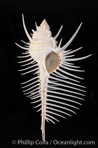
Venus comb murex. Scientists speculate that the distinctively long and narrow spines are a protection against fish and other mollusks and prevent the mollusk from sinking into the soft, sandy mud where it is commonly found.
Species: Venus comb murex, Murex pecten
Image ID: 12970
Species: Venus comb murex, Murex pecten
Image ID: 12970
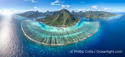
Barrier Reef around Moorea Island, French Polynesia. Cook's Bay to the left, Opunohu Bay to the right. The outer reef slope is seen adjacent to deep blue oceanic water with white waves breaking against the reef edge. Next, a wide shallow reef flat occurs dotted with coral bommies. Inside of that, a shallow protected lagoon is formed against the island. Tall, rugged, eroded mountains are seen hinting at the age of the ancient volcano that originally formed the island and that is now sinking back down, leaving the encircling reef behind.
Location: Moorea, French Polynesia, France
Image ID: 40676
Panorama dimensions: 5501 x 11925
Location: Moorea, French Polynesia, France
Image ID: 40676
Panorama dimensions: 5501 x 11925
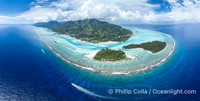
Barrier Reef around Moorea Island, French Polynesia. Motu Tiahura (left) and Motu Fareone (right) are the small islands in the foreground. The outer reef slope is seen adjacent to deep blue oceanic water with white waves breaking against the reef edge. Next, a wide shallow reef flat occurs dotted with coral bommies. Inside of that, a shallow protected lagoon is formed against the island. Tall, rugged, eroded mountains are seen hinting at the age of the ancient volcano that originally formed the island and that is now sinking back down, leaving the encircling reef behind.
Location: Moorea, French Polynesia, France
Image ID: 40614
Panorama dimensions: 5717 x 11305
Location: Moorea, French Polynesia, France
Image ID: 40614
Panorama dimensions: 5717 x 11305

A large herd of African elephants, composed of at least two familial groups, gathers at sunset to graze and socialize, Amboseli National Park.
Species: African elephant, Loxodonta africana
Location: Amboseli National Park, Kenya
Image ID: 39595
Panorama dimensions: 5803 x 20555
Species: African elephant, Loxodonta africana
Location: Amboseli National Park, Kenya
Image ID: 39595
Panorama dimensions: 5803 x 20555
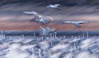
Sandhill cranes landing in water ponds at dusk, spending the night standing in water as a protection against coyotes and other predators. Motion blur.
Species: Sandhill crane, Grus canadensis
Location: Bosque del Apache National Wildlife Refuge, Socorro, New Mexico
Image ID: 38716
Species: Sandhill crane, Grus canadensis
Location: Bosque del Apache National Wildlife Refuge, Socorro, New Mexico
Image ID: 38716
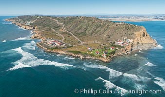
Aerial Photo of Cabrillo State Marine Reserve, Point Loma, San Diego.
Location: San Diego, California
Image ID: 30641
Location: San Diego, California
Image ID: 30641
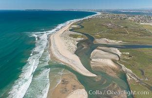
Aerial Photo of Tijuana River Mouth SMCA. Tijuana River Mouth State Marine Conservation Area borders Imperial Beach and the Mexican Border.
Location: Imperial Beach, California
Image ID: 30660
Location: Imperial Beach, California
Image ID: 30660
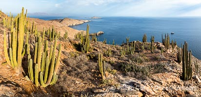
Aerial photo of Islas San Lorenzo in the Sea of Cortez. San Lorenzo Marine Archipelago National Park is a national park of Mexico located on San Lorenzo Island part of an archipelago in the Gulf of California off the eastern coast of Baja California. The San Lorenzo Archipelago is considered one of the most important ecological areas of the Gulf of California. The Island and surrounding areas are part of a rich ecosystem comprised by a grand variety of flora and marine fauna. This area is protected by the Mexican federal government Norma Oficial Mexicana because of its importance as a habitat for several endangered species.
Location: Islas San Lorenzo, Baja California, Mexico
Image ID: 40441
Location: Islas San Lorenzo, Baja California, Mexico
Image ID: 40441
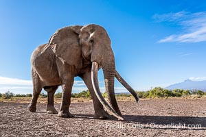
Craig, the Famous Old Male Tusker Elephant with the World's Largest Tusks, Amboseli National Park, Kenya.
Species: African elephant, Loxodonta africana
Location: Amboseli National Park, Kenya
Image ID: 39555
Species: African elephant, Loxodonta africana
Location: Amboseli National Park, Kenya
Image ID: 39555
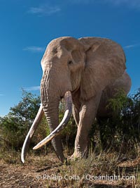
Craig the Famous Old Male Tusker Elephant with the World's Largest Tusks, Amboseli National Park, Kenya.
Species: African elephant, Loxodonta africana
Location: Amboseli National Park, Kenya
Image ID: 39557
Species: African elephant, Loxodonta africana
Location: Amboseli National Park, Kenya
Image ID: 39557
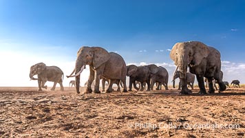
African Elephants, Large Herd Gathers at Sunset, Amboseli National Park.
Species: African elephant, Loxodonta africana
Location: Amboseli National Park, Kenya
Image ID: 39585
Species: African elephant, Loxodonta africana
Location: Amboseli National Park, Kenya
Image ID: 39585

African Elephants, Large Herd Gathers at Sunset, Amboseli National Park.
Species: African elephant, Loxodonta africana
Location: Amboseli National Park, Kenya
Image ID: 39586
Species: African elephant, Loxodonta africana
Location: Amboseli National Park, Kenya
Image ID: 39586
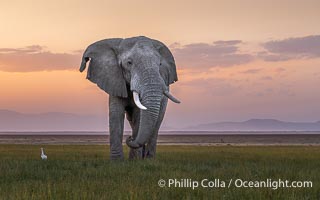
Solitary African Elephant at Sunset, Amboseli National Park.
Species: African elephant, Loxodonta africana
Location: Amboseli National Park, Kenya
Image ID: 39598
Species: African elephant, Loxodonta africana
Location: Amboseli National Park, Kenya
Image ID: 39598

African elephant herd crossing dry lake bed, Amboseli National Park.
Species: African elephant, Loxodonta africana
Location: Amboseli National Park, Kenya
Image ID: 39560
Species: African elephant, Loxodonta africana
Location: Amboseli National Park, Kenya
Image ID: 39560
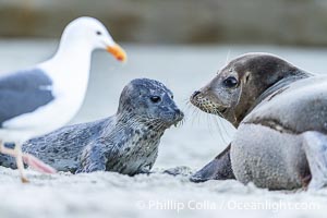
Newborn harbor seal pup is protected by its mother from a seagull. The seagull most likely wants to feed on the placenta, but it may also peck at and injure the pup. The seal mother does a good job of keeping birds off its newborn pup. Within an hour of being born, this pup had learned to nurse and had entered the ocean for its first swim.
Species: Pacific harbor seal, Phoca vitulina richardsi
Location: La Jolla, California
Image ID: 39075
Species: Pacific harbor seal, Phoca vitulina richardsi
Location: La Jolla, California
Image ID: 39075
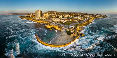
Childrens Pool Aerial Panoramic Photo at Sunset, people enjoying the sunset on the sea wall and the protected beach, Coast Boulevard in the foreground, Mount Soledad in the distance.
Location: La Jolla, California
Image ID: 38208
Panorama dimensions: 5582 x 11191
Location: La Jolla, California
Image ID: 38208
Panorama dimensions: 5582 x 11191

African elephant herd, Amboseli National Park, Kenya.
Species: African elephant, Loxodonta africana
Location: Amboseli National Park, Kenya
Image ID: 29531
Species: African elephant, Loxodonta africana
Location: Amboseli National Park, Kenya
Image ID: 29531
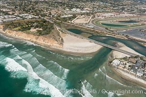
Aerial photo of San Dieguito Lagoon and Dog Beach. San Dieguito Lagoon State Marine Conservation Area (SMCA) is a marine protected area near Del Mar in San Diego County.
Location: Del Mar, California
Image ID: 30604
Location: Del Mar, California
Image ID: 30604
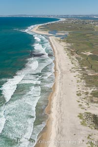
Aerial Photo of Tijuana River Mouth SMCA. Tijuana River Mouth State Marine Conservation Area borders Imperial Beach and the Mexican Border.
Location: Imperial Beach, California
Image ID: 30649
Location: Imperial Beach, California
Image ID: 30649
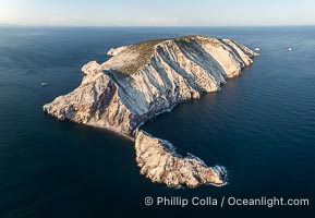
Isla San Pedro Martir at sunset with extensive forest of Cardon Cactus seen on the summit ridge of the island, aerial photo, Sea of Cortez, Mexico. San Pedro Martir Island and its marine life are, since 2002, part of the San Pedro Martir Biosphere Reserve, and is regarded as a natural laboratory of adaptive evolution, similar to that of the Galapagos Islands. It is home to 292 species of fauna and flora (both land-based and aquatic), with 42 species protected by Mexican law, and 30 listed on the Red List of Threatened Species. San Pedro Martir is also unique in the area for its year-round quantity of birds. The island is the only island in the area with a perpetually swirling cloud of sea birds. This is because the water around the island, has some of the most successful marine productivity in the world.
Location: Isla San Pedro Martir, Sonora, Mexico
Image ID: 40397
Location: Isla San Pedro Martir, Sonora, Mexico
Image ID: 40397
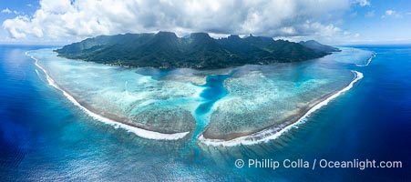
Barrier Reef around Moorea Island, French Polynesia. Nu'urua and Iumaru communities along the coast. The outer reef slope is seen adjacent to deep blue oceanic water with white waves breaking against the reef edge. Next, a wide shallow reef flat occurs dotted with coral bommies. Inside of that, a shallow protected lagoon is formed against the island. Tall, rugged, eroded mountains are seen hinting at the age of the ancient volcano that originally formed the island and that is now sinking back down, leaving the encircling reef behind.
Location: Moorea, French Polynesia, France
Image ID: 40666
Panorama dimensions: 5505 x 12416
Location: Moorea, French Polynesia, France
Image ID: 40666
Panorama dimensions: 5505 x 12416
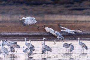
Sandhill cranes landing in water ponds at dusk, spending the night standing in water as a protection against coyotes and other predators. Motion blur.
Species: Sandhill crane, Grus canadensis
Location: Bosque del Apache National Wildlife Refuge, Socorro, New Mexico
Image ID: 38731
Species: Sandhill crane, Grus canadensis
Location: Bosque del Apache National Wildlife Refuge, Socorro, New Mexico
Image ID: 38731
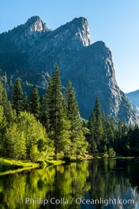
Three Brothers and Merced River in spring, Yosemite National Park.
Location: Yosemite National Park, California
Image ID: 36354
Location: Yosemite National Park, California
Image ID: 36354
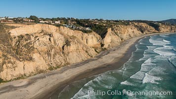
Aerial Photo of San Diego Scripps Coastal SMCA. Blacks Beach and Torrey Pines State Reserve.
Location: La Jolla, California
Image ID: 30736
Location: La Jolla, California
Image ID: 30736
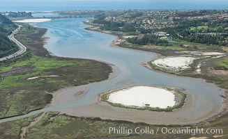
Aerial photo of Batiquitos Lagoon, Carlsbad. The Batiquitos Lagoon is a coastal wetland in southern Carlsbad, California. Part of the lagoon is designated as the Batiquitos Lagoon State Marine Conservation Area, run by the California Department of Fish and Game as a nature reserve.
Location: Carlsbad, Callifornia
Image ID: 30563
Location: Carlsbad, Callifornia
Image ID: 30563
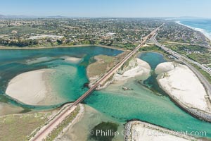
Aerial photo of Batiquitos Lagoon, Carlsbad. The Batiquitos Lagoon is a coastal wetland in southern Carlsbad, California. Part of the lagoon is designated as the Batiquitos Lagoon State Marine Conservation Area, run by the California Department of Fish and Game as a nature reserve.
Location: Carlsbad, Callifornia
Image ID: 30569
Location: Carlsbad, Callifornia
Image ID: 30569
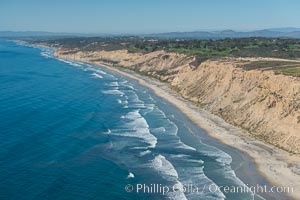
Aerial Photo of San Diego Scripps Coastal SMCA. Blacks Beach and Torrey Pines State Reserve.
Location: La Jolla, California
Image ID: 30622
Location: La Jolla, California
Image ID: 30622
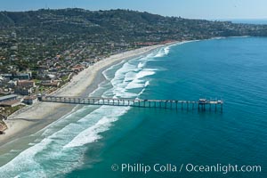
Aerial Photo of San Diego Scripps Coastal SMCA. Scripps Institution of Oceanography Research Pier.
Location: Scripps Institution of Oceanography, La Jolla, California
Image ID: 30626
Location: Scripps Institution of Oceanography, La Jolla, California
Image ID: 30626
