Map of Catalina Island Dive Sites and Locations
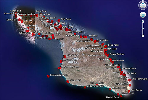
In the course of geotagging some old photos from Catalina Island, I realized it was simple to display the popular Catalina Island dive locations in Google Earth, Google Maps and Live Search Maps. So here they are. The map below is a small version of the Google Earth display, click on it to launch it in Google Earth and be able to zoom in much closer. You’ll need Google Earth installed on your computer for this to work. While it looks best in Google Earth, you can also view it in Google Maps and Live Search Maps, neither of which requires you to install any software to use.
![]() Map of Catalina Island Dive Sites in Google Earth, Google Maps, or Live Search Maps |
To see all of our photos keyworded with both “Catalina” and “Island” in Google Earth, click here: Catalina Island photos.
2 Comments »
Leave a comment
HOME | Online Image Search | Photo of the Day | Contact / Bio | Licensing/Pricing | Prints | Stock List | Image Hierarchy | List of Log Entries | Site Map | Blue Whale | Cetaceans | Pinnipeds | Sharks | Rays | Fishes | Kelp Forest | Sea Birds | Inverts | Man & Animal | Man & Ocean | Ocean & Light | Ocean & Motion | Portraits | About Color and Monitor Calibration | Copyright Statement | All text and photographs copyright © Phillip Colla Natural History Photography All rights reserved worldwide. The content of this site is made available for purposes of researching images offered for license by Phillip Colla Natural History Photography. No image is to be copied, duplicated, modified or redistributed in whole or part without the prior written permission of Phillip Colla Natural History Photography. Whale logo is a trademark of Phillip Colla Natural History Photography, 8021 Paseo Arrayan, Carlsbad, CA 92009, USA. 760.707.7153 Email: oceanlight@OceanLight.com Web: www.OceanLight.com Portfolios: www.Gygis.com
Updated: February 8, 2012


Excellent map Phil, the best that I’ve seen yet. Although one of my favorite sites, west end cove, is not on there. (just north of Land’s end, around the corner)
Comment by scott gietler — 11/12/2009 @ 7:11 pm
Thanks for this excellent resource - I’m sailing there (from LB) in a month and it’s great to have a map of all the spots.
Comment by Shane Ramey — 4/23/2010 @ 3:23 pm