I recently made a banzai road trip run up to Bodie State Historic Park, near Mono Lake, to make some photos. There is some danger that certain state parks in California may close soon due to budget cuts. I’ve wanted to see the Bodie ghost town for a while and figured with the danger of the park being closed soon I better get on with it. So I made a reservation a few weeks in advance for the Saturday sunrise photographer’s access and decided to give it a try. I got to the park gate about 30 minutes before sunrise, and to my delight found that only two other photographers were there that morning. Solitude, at sunrise, in one of the finest ghost towns in the country. (OK, granted, Bodie is not technically a “ghost town”, but I think of it that way.) I basically had the entire town to myself and did not bump into another person for at least an hour. It was quiet, cool, with clear skies and dew on the grass. I spent about two hours wandering around, peering around into the old homes, barns, shops and town halls. I had my pocket GPS recording the whole time, sitting inside my pocket. I shot wide (is there any other way?): 1DsIII with 16-35 and 1DsII with 24-70, along with my uber-mikro-mega-infrared-digikam for some infrared grab shots in black and white.
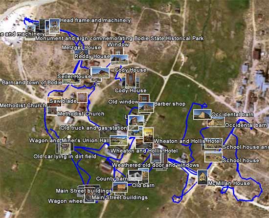
After returning home it was time caption my shots. I was very glad I had geocoded them! (See my post “How to Geocode Your Photos” for more info.) I had no inkling what the names of any of the buildings I had photographed were, with the exception of a few obvious images (e.g., gas station, car, church). However, since I had geocoded the images, I was able to display them on Google Earth with a simple click, along with a track showing my wandering path through the ghost town. (You will need Google Earth installed to display these links. Click the image below and it will load in Google Earth, displaying a selection of images and my foot path. You can then zoom to your heart’s delight.)

Bodie Wandering: Images and Footsteps. If you have Google Earth installed, click this image and it will load into Google Earth so that you can zoom and pan around.
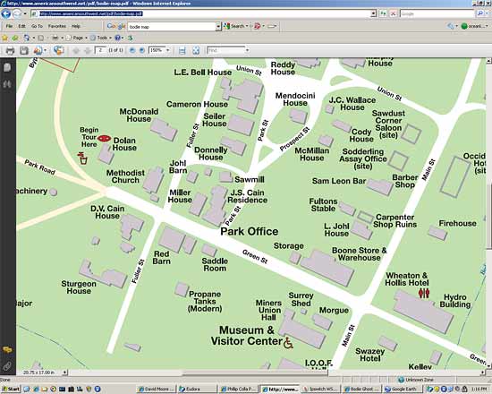
To identify my images, I simply compared the locations in the above Google Earth display (with each image shown exactly where it was taken in town) against this handy map identifying all the major building in town:
I had the two applications appearing on side-by-side monitors, zoomed in a little so the images in Google Earth did not overlap too much. In just a few minutes I was able to match up all of my shots with the correct names of the buildings portrayed in the photographs. Geocoding these saved me a LOT of time. Granted, I could have spent time logging notes while I was shooting, and referring to them later. However, I don’t keep a log. Of anything. So that approach doesn’t work for me. (I don’t log my diving, my running, my swimming, nothing. You don’t log your sex, do you? Then why would you log your photography?)
I just let the GPS do it for me, saves me a lot of time.
See more of my Bodie State Historic Park photos.


