Photos of Glacial Erratic Boulders
Some years ago I posted a blog entry about photos of glacial erratic boulders on Olmsted Point in Yosemite National Park. Well, I was recently there and got a few more. Glacial erratic boulders are so named because they are erratic (i.e., differ materially from the naturally occuring stone nearby) and they were deposited by slow-moving glaciers, sometimes after having been moved a considerable distance (e.g., tens of miles) from their place of origin. The boulders are carried by the glacier and then either fall off the side of the glacier as it slowly slides along, or are simply dropped in place if a glacier melts away. Olmsted Point, high above Tenaya Canyon, is a great location for seeing glacial erratic boulders. The same glaciers that sculpted nearby granite monoliths Half Dome and Cloud’s Rest, seen in the background of one these photos, also left behind many glacial erratic boulders on the rim of Tenaya Canyon when it passed by.
![]() |
| Glacial erratic boulders atop Olmsted Point, with the massive granite monoliths Half Dome and Clouds Rest in the background. Erratics are huge boulders left behind by the passing of glaciers which carved the granite surroundings into their present-day form. When the glaciers melt, any boulders and other geologic material that it was carrying are left in place, sometimes many miles from their original location. Image ID: 23264 Location: Yosemite National Park, California, USA View this Image in Google Earth! |
![]() |
| Glacial erratic boulders atop Olmsted Point. Erratics are huge boulders left behind by the passing of glaciers which carved the granite surroundings into their present-day form. When the glaciers melt, any boulders and other geologic material that it was carrying are left in place, sometimes many miles from their original location. Image ID: 23265 Location: Yosemite National Park, California, USA View this Image in Google Earth! |
See also: Yosemite National Park photos.
Keywords: glacial erratic boulder, geology, granite, Olmsted Point, Yosemite National Park, glacier, rock, stone.
Giant Sequoia Tree Photo
My in-laws live year-round very near the south entrance to Yosemite National Park. It only takes a few minutes for me to drive in and reach the Mariposa grove of giant sequoia trees (Sequoiadendron giganteum), so I will often go into the park early in the morning and take a run through the trees before anyone else arrives. This time I put my hiking boots on and brought a camera, hitting the trail about 6:30. There was nobody around, not even another car in the parking lot. I made a stop at the Bachelor and Three Graces (how can one not stop here?). Eventually, I found the most photogenic tree of the morning along the upper loop trail, lit nearly in its entirety by early morning sun while the surrounding trees were shaded.
![]() |
| A giant sequoia tree, soars skyward from the forest floor, lit by the morning sun and surrounded by other sequioas. The massive trunk characteristic of sequoia trees is apparent, as is the crown of foliage starting high above the base of the tree. Image ID: 23259 Species: Giant sequoia tree, Sequoiadendron giganteum Location: Mariposa Grove, Yosemite National Park, California, USA View this Image in Google Earth! |
![]() |
| Giant sequoia trees, roots spreading outward at the base of each massive tree, rise from the shaded forest floor. Image ID: 23258 Species: Giant sequoia tree, Sequoiadendron giganteum Location: Mariposa Grove, Yosemite National Park, California, USA View this Image in Google Earth! |
See more giant sequoia photos, Sequoiadendron giganteum, Mariposa Grove.
Keywords: sequoia, giant sequoia tree, photo, picture, image, Yosemite National Park, Mariposa Grove, Sequoiadendron giganteum.
Bodie State Historical Park Photos
I recently made a banzai road trip run up to Bodie State Park, near Mono Lake, to make some photos. I got to the park gate about 30 minutes before sunrise, and to my delight found that only two other photographers were there that morning. Solitude, at sunrise, in one of the finest ghost towns in the country. (OK, granted, Bodie is not technically a “ghost town”, but I think of it that way.) I basically had the entire town to myself and did not bump into another person for at least an hour. It was quiet, cool, with clear skies and dew on the grass. I spent about two hours wandering around, peering around into the old homes, barns, shops and town halls.
I have posted my Bodie State Historic Park photos on my website and also on Photoshelter: Bodie State Historic Photo stock photos.
![]() |
| Wagon and interior of County Barn, Brown House and Moyle House in distance. Bodie State Historical Park, California, USA. Image ID: 23106 Location: Bodie State Historical Park, California, USA View this Image in Google Earth! |
![]() |
| Wheaton and Hollis Hotel, interior of pool room and parlor. Bodie State Historical Park, California, USA. Image ID: 23110 Location: Bodie State Historical Park, California, USA View this Image in Google Earth! |
Vogelsang High Sierra Camp, Yosemite National Park
Photos of Vogelsang High Sierra Camp in Yosemite National Park
Note: I made a return trip to Vogelsang High Sierra Camp with my father in August 2010.
I made another banzai speed run up to the Eastern Sierra last weekend, this time to spend two nights at reknowned Vogelsang High Sierra Camp. This was my first visit to one of Yosemite’s high country camps, and I loved it. Dating back to the 1920’s, the High Sierra Camps consist of five wilderness camps (Vogelsang, Merced, Sunrise, Glen Aulin and May Lake) at altitudes ranging from 7,000′ to 10,000′, accomodating hikers with great meals, comfortable but spartan accomodations and incredible scenery. Backpackers also camp at these High Sierra Camps, and some backpackers opt to purchase meals at the mess tent while setting up their own campsite nearby. I opted to make a reservation and pay the full price in order to stay in the tent cabins with my own bed, and was rewarded with a lighter pack and no hassles setting up my campsite or carrying a bear can. Sure, I can carry a pack with full gear, but honestly I’ve got enough heavy camera gear to deal with so why not enjoy the comforts of the full-service camp? I’d definitely opt for the tent cabin again in the future so I can spend more time shooting photos, and leave the backpacking mode to others.
![]() |
| Townsley Lake, a beautiful alpine lake sitting below blue sky, clouds and Fletcher Peak (right), lies amid the Cathedral Range of glacier-sculpted granite peaks in Yosemite’s high country, near Vogelsang High Sierra Camp. Yosemite National Park, California, USA. Image ID: 23206 Location: Yosemite National Park, California, USA View this Image in Google Earth! |
I took the Rafferty Creek trail from Tuolumne Meadows to Vogelsang, the shorter of the two routes, since I did not get started until after 1pm. (I spent sunrise and the morning at Schulman Grove in the White Mountains looking at ancient Bristlecone Pine trees.) The Rafferty Creek trail is reasonably straightforward, with most of the work and elevation gain done in the first three miles, after which the trail wanders through the gradual incline of Rafferty Meadows with Fletcher Peak and Vogelsang Peak growing larger with each passing mile. I treated the trail as a workout, busted a move and reached the camp about 4pm, stopping once to demolish the mondo huge ham sandwich I picked up at Schaat’s Bakkery in Bishop. I washed up, greeted my tent-cabin-mates and made my way to the mess tent for a huge satisfying dinner (chicken, soup, potatoes, veggies, homemade soda bread, salad and chocolate cake). My plans to shoot star trail photos were waylaid as I realized my bed was more appealing than the meadow behind the camp, and I crashed hard.
![]() |
| Vogelsang Peak (11516′) at sunset, reflected in a Fletcher Creek near Vogelsang High Sierra Camp in Yosemite’s high country. Yosemite National Park, California, USA. Image ID: 23202 Location: Yosemite National Park, California, USA View this Image in Google Earth! |
Next morning I made a pre-sunrise hike up to nearby Vogelsang Lake and watched the sun play upon the lake, Vogelsang Peak which rises above it, and the surrounding granite terrain of the Cathedral Range. I made it back to camp just in time for breakfast: apple nut pancakes, eggs, bacon, sausage, oatmeal — killer. I never eat this well; I had to venture out into the sticks to get this great breakfast. I returned up to the lake and beyond to make a Vogelsang Pass panoramic photo, then a swim in the lake. I saw very few people. Back to camp for a midday nap after lunch, then off for an afternoon hike to the other side of Fletcher Peak to visit Fletcher Lake, Townsley Lake and Nameless Lake. I nearly bumped into a deer at Townsley Lake; if it had been 100 years ago and I had been named Phil Crockett I would have bagged me some fresh venison with nothing but my Swiss Army knife ap for my iPhone. A breeze came up keeping the mosquitoes down and me cool among the brilliant summertime scenery, making the afternoon one of the best hikes I’ve had in years. After I got back to camp for dinner, I met my new tent mates for my second evening in camp, including a fellow who had undergone two shoulder and two knee replacements. I realized that if this bionic man could hike the full High Sierra Loop, anyone can!
![]() |
| Panorama of Nameless Lake, surrounded by glacier-sculpted granite peaks of the Cathedral Range, near Vogelsang High Sierra Camp. Yosemite National Park, California, USA. Image ID: 23211 Location: Yosemite National Park, California, USA View this Image in Google Earth!Pano dimensions: 3756 x 9102 |
Dinner the second night was equally superb: steak, potatoes, string beans, salad, homemade bread and cheesecake. After dinner I made a half-hearted attempt to shoot high-ISO images of the Milky Way as it arched over the Sierra, but passing clouds made the results less than stellar. Off to bed. My second and final morning at Vogelsang meant one more dawn visit to the Vogelsang Lake, hoping for dramatic sunrise light. It almost clicked but not quite, but the views are so awesome from Vogelsang Lake that the sunrise hike was worth it even without photos. I was able to watch the backside of Half Dome light up as the sun rose, neat. Another killer breakfast, then depart camp at 9am for the all-downhill hike back to Tuolumne along Rafferty Creek. At the car by 11:30am, slurp down a ice cold Diet Coke and then buzzing south on 395 by noon.
My GPS says I made 30 miles in 2.5 days between my walk on the Methuselah Walk in the White Mountains and my hikes to, from and about Vogelsang in Yosemite. I’m not running much these days, knees giving me problems, so the hiking was not as smooth as I expected, but it sure was worth every step. The scenery was outright spectacular, mind blowing in its simplicity and beauty. It really is God’s Country up there.
Next time I visit I’ll make a few changes. First, I will visit later in the summer to avoid the thick mosquitoes. The higher meadows, including Vogelsang Camp, were full of mosquitoes while I was there. A head net and long sleeve shirts proved to be the trick, along with DEET on the legs, and I got only a few bites. But I’d rather try the camp again when mosquitoes are less dense. Another change I will make is to start my hike to Vogelsang earlier in the day so I can take the Lyell Canyon route, which is about 12 miles (compared to 7 for the Rafferty Creek route). I hiked the length of Lyell Canyon to Donohue Pass with some high school friends 30 years ago; it was awesome and I want to see some of that area again. I will summit Vogelsang Peak next time. I was most of the way there my first morning when I reached Vogelsang Pass, but decided not to make for the peak so I could bag a few lakes that afternoon; next time I’ll take the peak just so I can experience the view which I understand is tops. Lastly, I took too much stuff. I did not need all those Powerbars — the food at the camp was plentiful and delicious. I did not need three camera batteries, nor did I need those two heavy f/2.8 zoom lenses. I’m going commando next time, stripped down to the min for speed and agility. I’m going to bring my uber-mikro-pocket-digikam for shooting while on the trail, and save the big camera for when I am on dayhikes around the camp.
Vogelsang High Sierra Camp Pictures - Images by Phillip Colla |
You can see more Vogelsang High Sierra Camp photos on my website. Photoshelter also has the same collection of Vogelsang High Sierra Camp photos, along with a Vogelsang slideshow.
Keywords: Vogelsang High Sierra Camp, Yosemite National Park, photo, picture, images, stock pictures, photography.
Photo of Half Dome, Yosemite National Park
Half Dome is the one feature most closely associated with Yosemite National Park. A vast lobe of Mesozoic-era granodiorite magma cooled to rock, Half Dome was gradually uplifted to its present altitude of 8842 ft. As the rock was exposed, weathering and exfoliation of shell-like outer layers of the rock shaped the dome portion of the rock to its current shape. The summit is easily attainable as a day hike in the summer, if you have the stamina to undertake a 17-mile roundtrip hike with 5000 feet of elevation gain from the valley floor. To say that the view from the summit is worth the effort is an understatement. If you like this, please see more of my photos of Yosemite National Park.
![]() |
| Half Dome and storm clouds at sunset, viewed from Sentinel Bridge. Half Dome, Yosemite National Park, California, USA. Image: 22744 Location: Half Dome, Yosemite National Park, California, USA View this Image in Google Earth! |
Photo of El Capitan, Yosemite National Park
El Capitan, the massive granite monolith overlooking the western end of Yosemite Valley, is my favorite attraction in the park. It is beautiful and impressive from sunrise to sunset, under moonlight, in rain and when shrouded in mist. El Capitan, the largest known exposed granite block in the world, stands on the north side of the entrance to Yosemite Valley. Its name is Spanish for “the chief”, and this rock is indeed the most prominent feature of the west end of the Yosemite Valley, rivaled in significance only by Half Dome at the valley’s east end. At 3593 feet (1096 m) high, this massive rock is a popular — though difficult — climbing spot, attracting skilled big rock climbers from around the world. Visitors with binoculars can relax in El Capitan meadow to watch the climbers slowly make their way up the epic cliffs. Each year a few climbers are plucked off the sheer sides of El Capitan by a helicopter rescue team when they get in trouble. Ribbon Falls, on El Capitan’s west side, is Yosemite National Park’s highest unbroken waterfall (1612 ft, 492 m) and indeed one of the tallest in the world. Horsetail Falls, which flows off El Capitan for a few months in winter, produces a natural “firefall” for a few weeks in winter, if the conditions are right.
![]() |
| El Capitan eastern face, sunrise. Yosemite National Park, California, USA. Image: 22745 Location: Yosemite National Park, California, USA View this Image in Google Earth! |
As an alternative to the usual view of El Capitan above, a couple days ago I posted an infrared photo of El Capitan, in which the granite face stood in stark contrast to the tree below it and the cloud-free sky above. If you like this, please see more of my Yosemite National Park stock photos.
Infrared Photo of Yosemite Falls and Leidig Meadow
I used the same digital infrared camera to photograph Leidig Meadow with upper Yosemite Falls. The skies were totally socked in, there was light rain and virtually no color, so normal color photographs were unappealing and immediately deleted. But a black and white conversion of one of the color channels from an infrared photograph gave what I felt was an attractive rendition of this picturesque Yosemite meadow. If you like this be sure to see more photos of Yosemite National Park.
![]() |
| Yosemite Falls, mist and and storm clouds. Yosemite National Park, California, USA. Image: 22767 Location: Yosemite National Park, California, USA |
More infrared photographs.
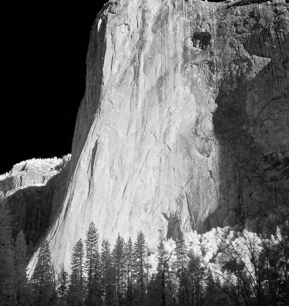
Infrared Photo of El Capitan, Yosemite
Here is an image of El Capitan, one of Yosemite Valley’s most iconic iconistic icons, made with an digital infrared camera. The camera senses infrared light only, rather than visible spectrum light, resulting in dark skies and foliage that glows. See more Yosemite National Park stock photos.
![]() |
| El Capitan eastern face, sunrise. Yosemite National Park, California, USA. Image: 22770 Location: Yosemite National Park, California, USA View this Image in Google Earth! |
More infrared photographs.
Photo of Mobius Arch, Alabama Hills
Mobius Arch Photograph
I made a banzai run up to the Alabama Hills last weekend. The weather forecast looked favorable, and I had not been up along the Eastern Sierra for some years, so it just seemed like the thing to do. I got up early to photograph Mobius Arch at sunrise. Mobius Arch, a natural stone arch, is the most striking and notable arch in the Alabama Hills. It is also known as Movie Road Arch, Alabama Hills Arch, Moebius Arch, and, in a tribute to photographer Galen Rowell, Galen’s Arch. Mobius Arch is about 17 feet wide and 6 feet high, and nicely frames both Lone Pine Peak and Mount Whitney in the Sierra Nevada range. Situated in the Owens Valley alongside the Sierra Nevada, just below Mt. Whitney, the Alabama Hills Recreational Area (administered by the BLM) is a 30,000 acre area of fantastic granite and metamorphosed rock, in an endless variety of rounded shapes and sizes.
![]() |
| Mobius Arch at sunrise, with Mount Whitney (the tallest peak in the continental United States), Lone Pine Peak and snow-covered Sierra Nevada Range framed within the arch. Mobius Arch is a 17-foot-wide natural rock arch in the scenic Alabama Hills Recreational Area near Lone Pine, California. Alabama Hills Recreational Area, California, USA. Image: 21729 |
![]() |
| Mobius Arch in the Alabama Hills, seen here at night with swirling star trails formed in the sky above due to a long time exposure. Image ID: 27681 Location: Alabama Hills Recreational Area, California, USA |
![]() |
| Mobius Arch at sunrise, framing snow dusted Lone Pine Peak and the Sierra Nevada Range in the background. Also known as Galen’s Arch, Mobius Arch is found in the Alabama Hills Recreational Area near Lone Pine. Image ID: 27627 Location: Alabama Hills Recreational Area, California, USA |
See more of our Mobius Arch photos
Keywords: Mobius Arch, photo, picture, Sierra Nevada, Alabama Hills, image, photograph, California, Lone Pine, Mount Whitney.
Photo of Mono Lake
A few photos from Mono Lake showing its famous tufa towers rising above its alkaline waters. The tufa towers are clustered in “groves” in several places around the lake. We checked out the South Grove. While we were walking around the edge of Mono Lake, we had low dense clouds of thousands of tiny alkali flies swarming over our feet, but only to a height of 6 inches or so, emitting a soft buzzing sound that moved around as they did. Its sounds strange but it was actually quite cool. The flies covered the ground so thickly in some places right at the edge of the water that the soil beneath them could barely be seen.
![]() |
| Tufa towers rise from Mono Lake. Tufa towers are formed when underwater springs rich in calcium mix with lakewater rich in carbonates, forming calcium carbonate (limestone) structures below the surface of the lake. The towers were eventually revealed when the water level in the lake was lowered starting in 1941. South tufa grove, Navy Beach. Mono Lake, California, USA. Image: 09929 Location: Mono Lake, California, USA View this Image in Google Earth! |
![]() |
![]() |
![]() |
| Tufa towers rise from Mono Lake with the Eastern Sierra visible in the distance. Tufa towers are formed when underwater springs rich in calcium mix with lakewater rich in carbonates, forming calcium carbonate (limestone) structures below the surface of the lake. The towers were eventually revealed when the water level in the lake was lowered starting in 1941. South tufa grove, Navy Beach. Mono Lake, California, USA. Image: 09932 |
Tufa towers rise from Mono Lake. Tufa towers are formed when underwater springs rich in calcium mix with lakewater rich in carbonates, forming calcium carbonate (limestone) structures below the surface of the lake. The towers were eventually revealed when the water level in the lake was lowered starting in 1941. South tufa grove, Navy Beach. Mono Lake, California, USA. Image: 09928 |
Tufa towers rise from Mono Lake. Tufa towers are formed when underwater springs rich in calcium mix with lakewater rich in carbonates, forming calcium carbonate (limestone) structures below the surface of the lake. The towers were eventually revealed when the water level in the lake was lowered starting in 1941. South tufa grove, Navy Beach. Mono Lake, California, USA. Image: 09931 |
Keywords: Mono Lake, tufa towers, photo, saline, picture, brine shrimp, image, Lee Vining, photo
Tenaya Lake Panoramic Photo
In late summer a few years ago we took the kids to spend a few nights in Tuolumne Meadows and then drive over Tioga Pass to see Mono Lake. We stopped at Lake Tenaya for a swim and a picnic lunch on the way to the meadows. This is a panoramic image, composed of 8 separate photographs stitched (on the computer) into a single picture.
![]() |
| Panorama of Tenaya Lake, in Yosemite’s high country. Image ID: 19121 Location: Tenaya Lake, Yosemite National Park, California, USA Pano dimensions: 2009 x 14383 |
Click the image to see it larger.
Minarets Panorama
On our way to a wedding in Tahoe last summer we stopped for a bit of fishing at Mammoth Lakes. I got up early and made a sunrise visit to the Minarets overlook, and got this view. This is a panoramic photograph, composed of 10 separate images stitched (on the computer) into a single, enormous file.
![]() |
| Panorama of the Minarets at sunrise, near Mammoth Mountain. The Minarets are a series of seventeen jagged peaks in the Ritter Range, west of Mammoth Mountain in the Ansel Adams Wilderness. These basalt peaks were carved by glaciers on both sides of the range. The highest of the Minarets stands 12,281 feet above sea level. Mammoth Lakes, California, USA. Image: 19123 Location: Mammoth Lakes, California, USA View this Image in Google Earth!Pano dimensions: 3233 x 26731 |
Click the image to see it larger.
Keywords: Minarets, photo, picture, Mammoth Lakes, image, photography, Sierra Nevada, California.
Photo of Nevada Falls, Yosemite National Park
Nevada Falls is one of Yosemite’s most spectacular waterfalls but is only reached with some effort. A 3.5 mile hike (one-way) up the Mist Trail, which includes a good soaking while passing by Vernal Falls along the way, is required to reach the summit of Nevada Falls, including 1900′ of vertical ascent. Nevada Falls lies, along with Vernal Falls, in the joints of narrow Little Yosemite Valley, faults in the valley that form angles and walls as the glacier-formed valley descends from Yosemite’s backcountry down to the main valley floor. It is at the joints that Nevada and Vernal falls occur, both dropping over sheer granite walls into boulder-strewn riverbeds below. Above Nevada Falls the Merced River flows placidly, green and glassy through pine forests. In the last several hundred yards before the brink, the river slopes downward a bit and increases in speed, enough that when it reaches the brink it shoots out dramatically and thunders 600′ down to the huge boulders before racing through forests to Vernal Falls 1.5 miles downstream. The hike to Nevada Falls begins at the summit of Vernal Falls, a natural resting point for the hiker who has just finished the soaking wet, thigh-burner steps alongside Vernal and needs a breather to recover and dry off in the sun. Leaving Vernal behind, one hikes through brief switchbacks open to the sun (not hot yet, since you are still wet) then through trees that obscure Nevada Falls for a while. After a half-mile or so the trees begin to open up, yielding stunning views of Nevada ahead. The trail then moves to a series of switchbacks among granite boulders that pass alongside Nevada Falls, near enough that one really appreciates the power manifest in the enormous amounts of water barreling over the cliff. Finally the summit is achieved, offering broad views of Little Yosemite Valley below all the across to Glacier Point. A bridge over the Merced River is placed just before the Merced plunges over the falls, and wide granite aprons on either side of the river make for great picnic spots. For the descent to Vernal Falls and the valley, its best to take the alternate route back down via the John Muir trail as it has superb views of Nevada Falls with Half Dome and Liberty Cap rising above it.
![]() |
| Nevada Falls marks where the Merced River plummets almost 600 through a joint in the Little Yosemite Valley, shooting out from a sheer granite cliff and then down to a boulder pile far below. Nevada Falls, Yosemite National Park, California, USA. Image: 16114 Location: Nevada Falls, Yosemite National Park, California, USA |
![]() |
![]() |
| Nevada Falls, with Liberty Cap (center) and Half Dome (left). Nevada Falls marks where the Merced River plummets almost 600 through a joint in the Little Yosemite Valley, shooting out from a sheer granite cliff and then down to a boulder pile far below. Nevada Falls, Yosemite National Park, California, USA. Image: 16115 |
Nevada Falls marks where the Merced River plummets almost 600 through a joint in the Little Yosemite Valley, shooting out from a sheer granite cliff and then down to a boulder pile far below. Nevada Falls, Yosemite National Park, California, USA. Image: 16116 |
Keywords: Nevada Falls, waterfall, Yosemite National Park<
Bridalveil Falls Rainbow
During spring months with heavy water flow, it is easy to see a rainbow in Bridalveil Falls: just visit the falls a short while before sunset and watch as the colors climb up the plummeting water as the sun sinks behind you.
![]() |
| Bridalveil Falls with a rainbow forming in its spray, dropping 620 into Yosemite Valley, displaying peak water flow in spring months from deep snowpack and warm weather melt. Yosemite Valley. Bridalveil Falls, Yosemite National Park, California, USA. Image: 16160 Location: Bridalveil Falls, Yosemite National Park, California, USA |
Keywords: bridalveil falls, yosemite national park, photo, picture, image, waterfall, photograph.
Yosemite Falls Lunar Rainbow
After getting word that the waterfalls in Yosemite are pouring at ginormous levels right now (due to a timely combination of last winter’s deep snowpack and recent warm weather), I blasted up to Yosemite Valley for a quickie. Indeed, all the falls were huge. As I drove into the Valley in the dark I could just see Bridalveil and Ribbon Falls going pretty good. A short while later I got a glimpse of Yosemite Falls, also raging. These were high flow levels I had seen in these falls only a few times before in my life, pretty special. I arrived just a few hours before the rising of the full moon Friday night hoping to see the famed “moonbow” of Yosemite Falls. When I got to the foot of Yosemite Falls about 10pm, I joined a small crowd of others who were also there to witness the lunar rainbow. Unfortunately, as I feared, the mist (re: rainstorm) at the foot of Yosemite Falls was so heavy there was no way to keep a camera dry; I was not about to get my gear out for a series of four-minute exposures, I take enough photos underwater as it is. There were a few guys giving it a try, so if they got anything perhaps they’ll publish their shots. Instead I spent the evening hiking around the valley, admiring the walls and falls in the moonlight from the relatively dry vantages of the meadows, a singular experience. At one point I was accompanied by a coyote hunting something (mice?) in one of meadows. We were surrounded by such quiet that I could hear his breathing and digging. It turns out that I did manage to obtain a lunar rainbow photo after all. Although I could not see it with my eyes at the time I took the photo below, the camera managed to capture the rainbow in the lower section of the falls (look hard, you’ll see it).
![]() |
| Yosemite Falls by moonlight, reflected in a springtime pool in Cooks Meadow. A lunar rainbow (moonbow) can be seen above the lower section of Yosemite Falls. Star trails appear in the night sky. Yosemite Valley. Yosemite Falls, Yosemite National Park, California, USA. Image: 16093 Location: Yosemite Falls, Yosemite National Park, California, USA View this Image in Google Earth! |
I spent the next day on the Mist Trail. It was a spectacular day, warm and clear with lots of people enjoying the drenching spray and giddying heights of the Mist and Panorama trails alongside Vernal Falls and Nevada Falls. I got some nice snaps.
Keywords: Yosemite falls, waterfall, yosemite national park, photo, picture, image, lunar, moon, night, photograph.
Photo of Fern Springs, Yosemite National Park
Fern Springs, near the entrance to Yosemite Valley, is a quietly running spring that crosses below the road and enters the Merced River. The small cascades offer a change of composition to the photographer looking for something to focus on aside from the towering granite walls and thundering waterfalls for which Yosemite is so well known.
![]() |
| Fern Springs, a small natural spring in Yosemite Valley near the Pohono Bridge, trickles quietly over rocks as it flows into the Merced River. Fern Springs, Yosemite National Park, California, USA. Image: 12650 Location: Fern Springs, Yosemite National Park, California, USA View this Image in Google Earth! |
![]() |
![]() |
| Fern Springs, a small natural spring in Yosemite Valley near the Pohono Bridge, trickles quietly over rocks as it flows into the Merced River. Yosemite Valley. Fern Springs, Yosemite National Park, California, USA. Image: 16084 |
Fern Springs, a small natural spring in Yosemite Valley near the Pohono Bridge, trickles quietly over rocks as it flows into the Merced River. Yosemite Valley. Fern Springs, Yosemite National Park, California, USA. Image: 16087 |
Keywords: Fern Springs, Yosemite National Park, photo, picture, image, photograph.
Photos of Bridalveil Falls, Yosemite National Park
Bridalveil Falls is a classic example of a “hanging valley”. Two million years ago it was a stream flowing through a canyon that intersected Yosemite Valley. Over time glaciers carved away the intersection, leaving Bridalveil’s canyon “hanging” above the valley and turning the stream into falls that plunge 620 feet (200m). Wind often blows the falls back and forth, producing a wide swath of mist that cools visitors who take the short hike to the base of the falls. Native indians referred to Bridalveil Falls as Pohono (”blowing wind”) and considered it to be a superstitious place. Bridalveil Fall, with a large absorbant watershed, flows year round. However, spring is the time to visit Yosemite National Park if you are interested in waterfalls. We make at least one visit to Yosemite Valley each spring, usually in May or early June, to see the park’s falls at their peak flow and to enjoy crisp cool mornings, verdant forests, blooming dogwood trees, a hike up the Mist Trail and Sunday brunch at the Ahwahnee. Bridalveil Falls is the first major water fall visitors see when entering Yosemite Valley, first seen we one emerges from the tunnel entrance to the west end of the valley, as it forms one side of the Gates of the Valley, then a short drive later it is observed from the floor of Yosemite Valley. Bridalveil Falls is a short, level walk from the parking lot to the base of the falls, through shady trees. When the falls are pumping the forest around the base of the falls is dripping wet and side streams form to pull the overflow from the falls down to the Merced River a few hundred yards away. In late afternoon a rainbow often forms in the spray of Bridalveil Falls, rising as the sun sinks.
![]() |
![]() |
| Bridalveil Falls. Bridalveil Falls, Yosemite National Park, California, USA. Image: 12646 |
Bridalveil Falls with a rainbow forming in its spray, dropping 620 into Yosemite Valley, displaying peak water flow in spring months from deep snowpack and warm weather melt. Yosemite Valley. Bridalveil Falls, Yosemite National Park, California, USA. Image: 16160 |
![]() |
![]() |
| Bridalveil Falls plummets 620 feet (200m). Yosemite Valley. Bridalveil Falls, Yosemite National Park, California, USA. Image: 16077 |
Bridalveil Falls plummets 620 feet (200m). Yosemite Valley. Bridalveil Falls, Yosemite National Park, California, USA. Image: 16080 |
See some other waterfalls in Yosemite Valley: Yosemite Falls, Vernal Falls and Horsetail Falls.
Keywords: Bridalveil Falls, waterfall, Yosemite National Park, Yosemite Valley, California, photo, picture, image, pho
Photo of Tenaya Lake, Yosemite National Park
Tenaya Lake lies in the high country of Yosemite National Park, surrounded by enormous granite domes and coniferous forests.
![]() |
| Tenaya Lake is surrounded by epic granite domes. Late afternoon, viewed from Olmstead Point. Tenaya Lake, Yosemite National Park, California, USA. Image: 09955 Location: Tenaya Lake, Yosemite National Park, California, USA |
![]() |
| Tenaya Peak rises above Tenaya Lake near Tuolumne Meadows. Tenaya Lake, Yosemite National Park, California, USA. Image: 09957 Location: Tenaya Lake, Yosemite National Park, California, USA |
Keywords: Tenaya Lake, Tuolumne Meadows, Yosemite National Park, photo, picture, image.
Photo of Mammoth Peak, Yosemite National Park
Mammoth Peak rises above Tioga Lake and Tuolumne Meadows in the high country of Yosemite National Park.
![]() |
| Mammoth Peak in the High Sierra range is reflected in Tioga Lake at sunrise. This spectacular location is just a short walk from the Tioga Pass road. Near Tuolumne Meadows and Yosemite National Park. Tioga Lake, Yosemite National Park, California, USA. Image: 09948 Location: Tioga Lake, Yosemite National Park, California, USA |
![]() |
| Mammoth Peak and alpine meadows in the High Sierra are reflected in Tioga Lake at sunrise. This spectacular location is just a short walk from the Tioga Pass road. Near Tuolumne Meadows and Yosemite National Park. Tioga Lake, Yosemite National Park, California, USA. Image: 09949 Location: Tioga Lake, Yosemite National Park, California, USA |
Keywords: Mammoth Peak, Tioga Lake, Tuolumne Meadows, Yosemite National Park, photo, image, picture.
Photo of Lembert Dome, Yosemite National Park
Lembert Dome rises above Tuolumne Meadows in the high country of Yosemite National Park. The hike to the summit of Lembert Dome is easy and leads through a forest of trees before emerging on the backside of the dome, and offers expansive view of the entire Tuolumne Meadows from the top.
![]() |
| Lembert Dome and late afternoon clouds rise above Tuolumne Meadows in the High Sierra, catching the fading light of sunset. Tuolumne Meadows, Yosemite National Park, California, USA. Image: 09939 Location: Tuolumne Meadows, Yosemite National Park, California, USA |
![]() |
![]() |
![]() |
| Lembert Dome and late afternoon clouds rise above Tuolumne Meadows in the High Sierra, catching the fading light of sunset. Tuolumne Meadows, Yosemite National Park, California, USA. Image: 09938 |
The Tuolumne River flows serenely through Tuolumne Meadows in the High Sierra. Lembert Dome is seen in the background. Tuolumne Meadows, Yosemite National Park, California, USA. Image: 09940 |
Lembert Dome rises above Tuolumne Meadows in the High Sierra, catching the fading light of sunset. Tuolumne Meadows, Yosemite National Park, California, USA. Image: 09944 |
Keywords: Lembert Dome, Tuolumne Meadows, Yosemite National Park, photo, image, pictur
HOME | Online Image Search | Photo of the Day | Contact / Bio | Licensing/Pricing | Prints | Stock List | Image Hierarchy | List of Log Entries | Site Map | Blue Whale | Cetaceans | Pinnipeds | Sharks | Rays | Fishes | Kelp Forest | Sea Birds | Inverts | Man & Animal | Man & Ocean | Ocean & Light | Ocean & Motion | Portraits | About Color and Monitor Calibration | Copyright Statement | All text and photographs copyright © Phillip Colla Natural History Photography All rights reserved worldwide. The content of this site is made available for purposes of researching images offered for license by Phillip Colla Natural History Photography. No image is to be copied, duplicated, modified or redistributed in whole or part without the prior written permission of Phillip Colla Natural History Photography. Whale logo is a trademark of Phillip Colla Natural History Photography, 8021 Paseo Arrayan, Carlsbad, CA 92009, USA. 760.707.7153 Email: oceanlight@OceanLight.com Web: www.OceanLight.com Portfolios: www.Gygis.com
Updated: May 23, 2012


