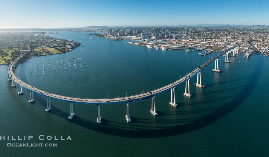
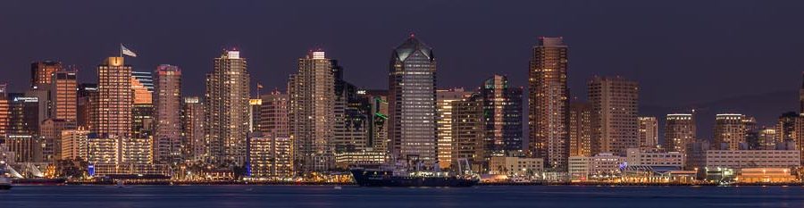
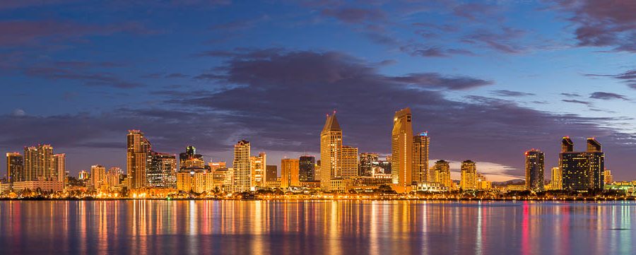
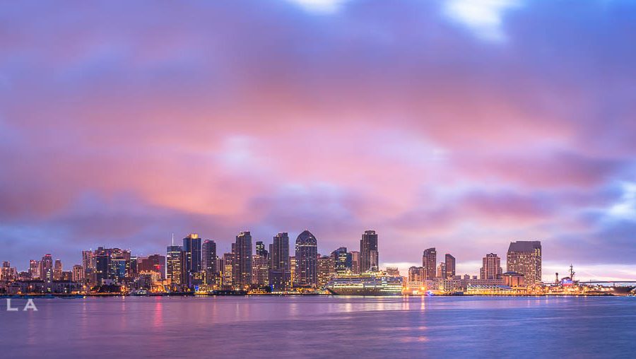
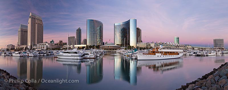
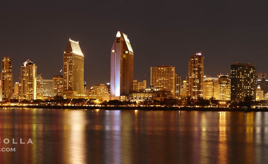
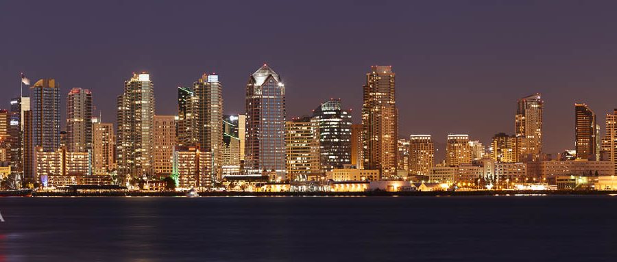
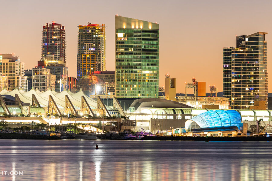
Panoramas :: Photo Of The Day and Natural History Commentary

9/21/2007

Guadalupe Island Panorama

Filed under:  

I shot this panorama, a series of six photographs, one morning last week, shortly after sunrise, from the upper deck of the boat Horizon. Guadalupe Island was covered in that great golden sunrise light that only lasts for a few minutes. The ocean surrounding the island was covered in clouds, but we were sitting in a broad pocket of clear sky – the 4257′ tall island was holding the clouds back. You can just see some clouds peeking over the topmost ridge, but that’s as far as they got. A beautiful morning.

Guadalupe Island at sunrise, panorama.  Volcanic coastline south of Pilot Rock and Spanish Cove, near El Faro lighthouse.,  Copyright Phillip Colla, image #19497, all rights reserved worldwide.
Guadalupe Island at sunrise, panorama. Volcanic coastline south of Pilot Rock and Spanish Cove, near El Faro lighthouse. Guadalupe Island (Isla Guadalupe), Baja California, Mexico.
Image: 19497  
Location: Guadalupe Island (Isla Guadalupe), Baja California, Mexico
Pano dimensions: 2797 x 16157
 

8/30/2007

Columbia River Viewed From Vista House

Filed under:  

Vista House was built in 1918 as a memorial to Oregon pioneers and as a comfort station for those traveling on the Historic Columbia River Highway. The octagonal stone structure towers 733 feet above the Columbia River and provides a spectacular view. Click it to see it larger.

Panoramic view of the Columbia River as it flows through Columbia River Gorge Scenic Area, looking east from the Vista House overlook on the southern Oregon side of the river.,  Copyright Phillip Colla, image #19374, all rights reserved worldwide.
Panoramic view of the Columbia River as it flows through Columbia River Gorge Scenic Area, looking east from the Vista House overlook on the southern Oregon side of the river.
Image: 19374  
Pano dimensions: 3125 x 21408
 

8/29/2007

North Head Lighthouse, Washington

Filed under:  

While in Astoria recently, we took a little drive across to the Washington side of the Columbia River to see North Head Lighthouse. It was overcast, sort of pre-storm looking, perfect weather for walking around a blustery promontory high above the coast and checking out an old lighthouse. Below is a panorama of the bluffs beside the North Head Lighthouse, spanning about 180 degrees up and down the coast. Can you see my daughter next to the lens inside the top room of the lighthouse? Click it to see a larger version.

The North Head Lighthouse was built in 1896. 69 steps lead to the lantern room, which is 65 feet from the ground and 194 feet above sea level. The first-order Fresnel lens, which came from Cape Disappointment, was lit for the first time on May 16, 1898.,  Copyright Phillip Colla, image #19390, all rights reserved worldwide.
The North Head Lighthouse was built in 1896. 69 steps lead to the lantern room, which is 65 feet from the ground and 194 feet above sea level. The first-order Fresnel lens, which came from Cape Disappointment, was lit for the first time on May 16, 1898. Washington, USA.
Image: 19390  
Location: Washington, USA
Pano dimensions: 4757 x 20503
 

8/28/2007

Lunar Eclipse Photo

Filed under:  

I took some photos of the total lunar eclipse last night from my backyard. At the peak of the eclipse, when the moon was totally in the Earth’s shadow, no direct sunlight reached the moon so it was lit only faintly by light refracting (bending) through the relatively thin layer of the Earth’s atmosphere. As this refracted light passes through smoke, dust, smog and haze in the atmosphere, it takes on a distinct red tint. Since direct light reaching the moon is whitish-yellow and is many orders of magnitude stronger than the red-tinged refracted light, the red color is only observed at total eclipse when it does not have to compete with direct sunlight. Thus comes the name “blood moon” for such an eclipse. Click the panorama strip to see it larger.

Lunar eclipse sequence, showing total eclipse (left) through full moon (right).  While the moon lies in the full shadow of the earth (umbra) it receives only faint, red-tinged light refracted through the Earth's atmosphere.  As the moon passes into the penumbra it receives increasing amounts of direct sunlight, eventually leaving the shadow of the Earth altogether.  August 28, 2007.,  Copyright Phillip Colla, image #19391, all rights reserved worldwide.
Lunar eclipse sequence, showing total eclipse (left) through full moon (right). While the moon lies in the full shadow of the earth (umbra) it receives only faint, red-tinged light refracted through the Earth’s atmosphere. As the moon passes into the penumbra it receives increasing amounts of direct sunlight, eventually leaving the shadow of the Earth altogether. August 28, 2007. Earth Orbit, Solar System, Milky Way Galaxy, The Universe.
Image: 19391  
Location: Earth Orbit, Solar System, Milky Way Galaxy, The Universe
Pano dimensions: 1826 x 14162
 

For some reason this animated GIF looks terrible compared to the actual images out of the camera, something about limiting to 256 colors I think. Anyway, here is an animated version, over roughly one and 1/2 hours from full eclipse to no eclipse:


8/17/2007

Lake Tahoe Panorama

Filed under:  

Last summer we went to Lake Tahoe for a wedding. Lake Tahoe in summer is beautiful. I found a turnout on the highway above Incline Village which offered this view. This is a panoramic photograph obtained by stitching 6 separate images together on the computer.

Panorama of Lake Tahoe, viewed from above Incline Village.  Sitting between the Carson Range to the east and the Sierra Nevada to the west, Lake Tahoe was formed about 2 to 3 million years ago and is now the second deepest lake in the United States, and tenth deepest in the world, at 1645 ft (501m) deep.  It lies at an altitude of 6225 feet (1897m) above sea level. This view is from the north end of Lake Tahoe looking south.,  Copyright Phillip Colla, image #19128, all rights reserved worldwide.
Panorama of Lake Tahoe, viewed from above Incline Village. Sitting between the Carson Range to the east and the Sierra Nevada to the west, Lake Tahoe was formed about 2 to 3 million years ago and is now the second deepest lake in the United States, and tenth deepest in the world, at 1645 ft (501m) deep. It lies at an altitude of 6225 feet (1897m) above sea level. This view is from the north end of Lake Tahoe looking south. Lake Tahoe, Incline Village, Nevada, USA.
Image: 19128  
Location: Lake Tahoe, Incline Village, Nevada, USA
Pano dimensions: 3116 x 20490
 

8/15/2007

Mount St. Helens Panorama

Filed under:  

From the 2005 archives: I left Seattle in the late afternoon and began my speed run south, home to Carlsbad. I planned to stop at three spots: Mount St. Helens, Crater Lake and Oakland. I reached the Johnston Ridge viewpoint of Mount St. Helens National Volcanic Monument (say that three times quickly) before sunset and had the entire place to myself. It was eerie, I was wondering if I had missed an eruption warning or something. This is a panoramic photograph, composed of 4 separate images stitched (on the computer) into a single picture.

Panorama of Mount St. Helens, viewed from Johnston Ridge.,  Copyright Phillip Colla, image #19118, all rights reserved worldwide.
Panorama of Mount St. Helens, viewed from Johnston Ridge. Mount St. Helens National Volcanic Monument, Washington, USA.
Image: 19118  
Location: Mount St. Helens National Volcanic Monument, Washington, USA
Pano dimensions: 3058 x 14970
 

Click the image to see it larger.


8/14/2007

Tenaya Lake Panorama

Filed under:  

In late summer a few years ago we took the kids to spend a few nights in Tuolumne Meadows and then drive over Tioga Pass to see Mono Lake. We stopped at Lake Tenaya for a swim and a picnic lunch on the way to the meadows. This is a panoramic photograph, composed of 8 separate images stitched (on the computer) into a single picture.

Panorama of Tenaya Lake, in Yosemite's high country.,  Copyright Phillip Colla, image #19122, all rights reserved worldwide.
Panorama of Tenaya Lake, in Yosemite’s high country. Yosemite National Park, California, USA.
Image: 19122  
Location: Yosemite National Park, California, USA
Pano dimensions: 2013 x 15517
 

Click the image to see it larger.


8/9/2007

Minarets Panorama

Filed under:  

On our way to a wedding in Tahoe last summer we stopped for a bit of fishing at Mammoth Lakes. I got up early and made a sunrise visit to the Minarets overlook, and got this view. This is a panoramic photograph, composed of 10 separate images stitched (on the computer) into a single, enormous file.

Panorama of the Minarets at sunrise, near Mammoth Mountain.  The Minarets are a series of seventeen jagged peaks in the Ritter Range, west of Mammoth Mountain in the Ansel Adams Wilderness.  These basalt peaks were carved by glaciers on both sides of the range.  The highest of the Minarets stands 12,281 feet above sea level.,  Copyright Phillip Colla, image #19123, all rights reserved worldwide.
Panorama of the Minarets at sunrise, near Mammoth Mountain. The Minarets are a series of seventeen jagged peaks in the Ritter Range, west of Mammoth Mountain in the Ansel Adams Wilderness. These basalt peaks were carved by glaciers on both sides of the range. The highest of the Minarets stands 12,281 feet above sea level. Mammoth Lakes, California, USA.
Image: 19123  
Location: Mammoth Lakes, California, USA
Pano dimensions: 3233 x 26731
 

Click the image to see it larger.


8/3/2007

Exit Glacier Panorama

Filed under:  

While visiting Kenai Fjords National Park recently, I spent the morning taking an easy hike up to the terminal end (terminus?) of Exit Glacier. This is a popular spot, since it is a gentle hike and it is the main attraction of the only road that enters the national park. I think that I was the first person on the trail that morning, since there were no cars in the parking lot and I saw nobody else until I was nearly done with my walk. The weather was great: full sun, warm and quiet. I was hoping to see a bear or moose or something, but the only wildlife I saw was a fat old marmot who hung out until I got my camera at which point he ditched me. This is a panoramic photograph, composed of 10 separate images stitched (on the computer) into a single, enormous file. Note that this is actually a double-self-portrait, as I appear there twice in a manner of sorts. How’d he do dat?

Self portrait, panorama of Exit Glacier.  Exit Glacier, one of 35 glaciers that are spawned by the enormous Harding Icefield, is the only one that can be easily reached on foot.,  Copyright Phillip Colla, image #19112, all rights reserved worldwide.
Self portrait, panorama of Exit Glacier. Exit Glacier, one of 35 glaciers that are spawned by the enormous Harding Icefield, is the only one that can be easily reached on foot. Kenai Fjords National Park, Alaska, USA.
Image: 19112  
Location: Kenai Fjords National Park, Alaska, USA
Pano dimensions: 4298 x 17211
 

Click the image to see it larger.


8/1/2007

Schwabacher Landing Panoramic Photograph

Filed under:  

Schwabacher Landing is one of the “must get” spots for photographers visiting Grand Teton National Park. There is a beaver pond a short ways up a fisherman’s trail in which the Teton Range is nicely reflected in a mirror-calm sidewater of the Snake River, making for a postcard view. I make a point of visiting Schwabacher Landing at least once each time I visit, taking a look for the beavers and hoping to see a moose if I’m lucky. Here is a shot of Schwabacher Landing in Grand Teton National Park, Wyoming. Early morning, summer. This image is formed by stitching nine separate images into a longer panoramic strip.

Panorama of the Teton Range reflected in the still waters of Schwabacher Landing, a sidewater of the Snake River.,  Copyright Phillip Colla, image #19129, all rights reserved worldwide.
Panorama of the Teton Range reflected in the still waters of Schwabacher Landing, a sidewater of the Snake River. Grand Teton National Park, Wyoming, USA.
Image: 19129  
Location: Grand Teton National Park, Wyoming, USA
Pano dimensions: 3104 x 27272
 

Click the image to see it larger.


7/31/2007

Crater Lake Panoramic Photograph

Filed under:  

I had always wanted to see Crater Lake and finally got a chance when I was returning to southern California from Washington. I reached the north rim of Crater Lake just as the sun was rising. There was no one else around, even on the drive through the dark leading into Crater Lake National Park I had seen nobody else that morning. The view was stunning, sublime and I felt like I had the place entirely to myself, so naturally I took a self portrait. This panorama is composed of four separate photographs stitched into a long narrow strip.

Self portrait at sunrise, panorama of Crater Lake.  Crater Lake is the six-mile wide lake inside the collapsed caldera of volcanic Mount Mazama. Crater Lake is the deepest lake in the United States and the seventh-deepest in the world. Its maximum recorded depth is 1996 feet (608m). It lies at an altitude of 6178 feet (1880m).,  Copyright Phillip Colla, image #19130, all rights reserved worldwide.
Self portrait at sunrise, panorama of Crater Lake. Crater Lake is the six-mile wide lake inside the collapsed caldera of volcanic Mount Mazama. Crater Lake is the deepest lake in the United States and the seventh-deepest in the world. Its maximum recorded depth is 1996 feet (608m). It lies at an altitude of 6178 feet (1880m). Crater Lake National Park, Oregon, USA.
Image: 19130  
Location: Crater Lake National Park, Oregon, USA
Pano dimensions: 2726 x 9677
 

Click the image to see it larger.


HOME | Online Image Search | Photo of the Day | Contact / Bio | Licensing/Pricing | Prints | Stock List | Image Hierarchy | List of Log Entries | Site Map | Blue Whale | Cetaceans | Pinnipeds | Sharks | Rays | Fishes | Kelp Forest | Sea Birds | Inverts | Man & Animal | Man & Ocean | Ocean & Light | Ocean & Motion | Portraits | About Color and Monitor Calibration | Copyright Statement | All text and photographs copyright © Phillip Colla Natural History Photography   All rights reserved worldwide. The content of this site is made available for purposes of researching images offered for license by Phillip Colla Natural History Photography.  No image is to be copied, duplicated, modified or redistributed in whole or part without the prior written permission of Phillip Colla Natural History Photography.  Whale logo is a trademark of Phillip Colla Natural History Photography, 7302 Azalea Place, Carlsbad, CA 92011, USA.  (760) 804-0731.  Email: oceanlight@OceanLight.com    Web: www.OceanLight.com      Portfolios: www.Gygis.com

Updated: May 16, 2008