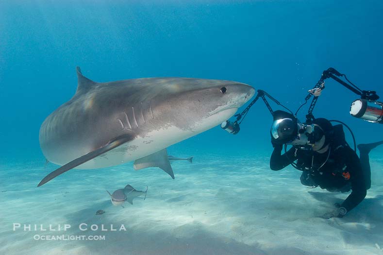
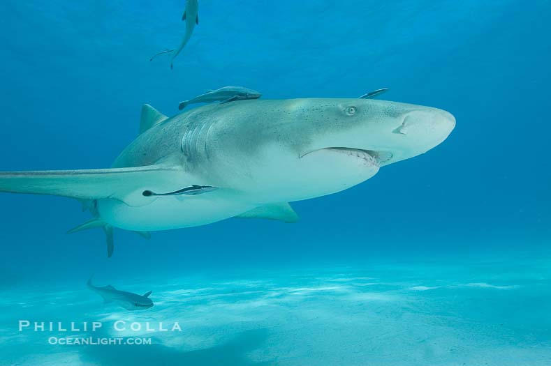
Lemon Shark Photo, Northern Bahamas
On our recent trip to the Northern Bahamas in search of sharks, we encountered lots of lemon sharks (Negaprion brevirostris) alongside the tiger sharks (Galeocerdo cuvier). The lemon sharks were comfortable coming in for a close look and afforded literally hundreds of good photo opportunities on a single 90 minute dive. Some of the lemons were accompanied by up to a dozen live sharksuckers (Echeneis naucrates), a type of remora. Once in a while one of the sharksuckers would peel of its lemon shark host and swim around us for a while. After a while we began to ignore the lemons in an effort to keep our eyes on the considerably more impressive tiger sharks. Here are a few shots of the lemons:
|
|
| Lemon shark with live sharksuckers. Bahamas. Image: 10754 Species: Negaprion brevirostris, Echeneis naucrates |
|
|
|
|
| Lemon shark with live sharksuckers. Bahamas. Image: 10752 Species: Negaprion brevirostris, Echeneis naucrates |
Lemon shark with live sharksuckers. Bahamas. Image: 10753 Species: Negaprion brevirostris, Echeneis naucrates |
Lemon shark with live sharksuckers. Bahamas. Image: 10756 Species: Negaprion brevirostris, Echeneis naucrates |
|
|
|
|
| Lemon shark with live sharksuckers. Bahamas. Image: 10757 Species: Negaprion brevirostris, Echeneis naucrates |
Lemon shark. Bahamas. Image: 10758 Species: Negaprion brevirostris |
Lemon shark and photographer Jim Abernethy. Bahamas. Image: 10760 Species: Negaprion brevirostris |
Keywords: lemon shark photo, Negaprion brevirostris, Northern Bahamas, lemon sharks, lemon shark pictures, underwater photos.
Red Barrel Cactus Photos, Anza Borrego Desert State Park
Thanks to John Dougherty for kindly helping us to correctly identify a number of flowering plants from recent visits to Anza-Borrego Desert State Park. One of our favorite subjects was the Red Barrel Cactus (Ferocactus cylindraceus) which were just beginning to show their blooms.
![]() |
| Barrel cactus, brittlebush and wildflowers color the sides of Glorietta Canyon. Heavy winter rains led to a historic springtime bloom in 2005, carpeting the entire desert in vegetation and color for months. Anza-Borrego Desert State Park, Anza Borrego, California, USA. Image: 10899 Species: Ferocactus cylindraceus, Encelia farinosa Location: Anza-Borrego Desert State Park, Anza Borrego, California, USA View this Image in Google Earth! |
![]() |
| Barrel cactus, Glorietta Canyon. Heavy winter rains led to a historic springtime bloom in 2005, carpeting the entire desert in vegetation and color for months. Anza-Borrego Desert State Park, Anza Borrego, California, USA. Image: 10906 Species: Ferocactus cylindraceus Location: Anza-Borrego Desert State Park, Anza Borrego, California, USA View this Image in Google Earth! |
![]() |
| Barrel cactus, Glorietta Canyon. Heavy winter rains led to a historic springtime bloom in 2005, carpeting the entire desert in vegetation and color for months. Anza-Borrego Desert State Park, Anza Borrego, California, USA. Image: 10905 Species: Ferocactus cylindraceus Location: Anza-Borrego Desert State Park, Anza Borrego, California, USA View this Image in Google Earth! |
![]() |
| Barrel cactus, brittlebush, ocotillo and wildflowers color the sides of Glorietta Canyon. Heavy winter rains led to a historic springtime bloom in 2005, carpeting the entire desert in vegetation and color for months. Anza-Borrego Desert State Park, Anza Borrego, California, USA. Image: 10919 Species: Ferocactus cylindraceus, Encelia farinosa, Fouquieria splendens Location: Anza-Borrego Desert State Park, Anza Borrego, California, USA View this Image in Google Earth! |
Keywords: barrel cactus photo, flowering cactus, cacti, red barrel cactus, ferocactus, desert Anza-Borrego desert state park.
Canyon Sunrise, Anza Borrego Desert State Park
Anza Borrego Desert State Park is currently experiencing an epic, once-in-a-lifetime bloom of desert wildflowers, bushes and cacti. The sand verbena and desert primrose flowers that had covered the valley floor so spectacularly in places in February seem to be receding or largely gone, replaced with poppies and lupine. However, the principal attraction now is a profusion of brittlebush filling the canyons and coloring the hillsides on the east side of the valley with yellow. The slopes along the Montezuma Grade leading down to Borrego Springs from the west are bright with brittlebush, so that they appear entirely yellow and green from afar. The density of brittlebush continues down toward the valley and into the canyons, washes and alluvial fans. Barrel and cholla cactus and ocotillo are just now beginning to bloom, so desert color in Anza Borrego should continue to improve for at least a few more weeks. There are many small assorted flowers still, along with caterpillers (munching the flowers) and butterflies. The following is a blended exposure shot at sunrise, composed of three images blended to account for the extreme range of light that neither film nor digital sensor can adequately capture in a single exposure:
![]() |
| Brittlebush, ocotillo and various cacti and wildflowers color the sides of Glorietta Canyon. Heavy winter rains led to a historic springtime bloom in 2005, carpeting the entire desert in vegetation and color for months. Anza-Borrego Desert State Park, Anza Borrego, California, USA. Image: 10895 Species: Encelia farinosa, Fouquieria splendens Location: Anza-Borrego Desert State Park, Anza Borrego, California, USA View this Image in Google Earth! |
See all the photos from this shoot.
Keywords: Anza Borrego Desert State Park, photo, photographs, wildflower.
California Sea Lions, Baja California
Each winter California sea lions (Zalophus californianus) gather in the hundreds on the rock slopes of North Coronado Island, just south of the US/Mexico border. The bottom diving is unremarkable here the remainder of the year, but when the sea lions are gathered in such numbers it is worth making the short boat trip for a dive with them.
![]() |
| California sea lions, hauled out at rookery/colony, Baja California. Image: 05042 Species: Zalophus californianus View this Image in Google Earth! |
Keywords: California sea lion photo, rookery, colony, Zalophus californianus, Coronado Islands, Islas Coronado.
Tiger Shark and Keith Grundy, Northern Bahamas
We recently spent 8 days on the MV Shearwater in the Northern Bahamas, in search of various species of sharks to swim with and photograph. The most impressive of the ones we encountered were the tiger sharks (Galeocerdo cuvier). They ranged in size from 9 feet to perhaps 14 feet, big enough to be quite intimidating. One large one in particular made a good photo subject as it was willing to approach the divers closely. Here is underwater photographer Keith Grundy being treated to a close look at a 13 foot tiger shark that Shearwater skipper and owner Jim Abernethy named “Emma”:
![]() |
| Tiger shark and photographer Keith Grundy. Bahamas. Image: 10649 Species: Galeocerdo cuvier Location: Bahamas View this Image in Google Earth! |
Keywords: tiger shark photo, Keith Grundy, Bahamas, underwater photograph, Caleocerdo cuvier.
Linanthus Dianthiflorus, Batiquitos Lagoon
We found a great spread of Linanthus dianthiflorusin a small canyon leading off of Batiquitos Lagoon in South Carlsbad:
![]() |
| Ground pink blooms in spring, Batiquitos Lagoon, Carlsbad. Batiquitos Lagoon, Carlsbad, California, USA. Image: 11486 Species: Linanthus dianthiflorus Location: Batiquitos Lagoon, Carlsbad, California, USA View this Image in Google Earth! |
![]() |
| Ground pink blooms in spring, Batiquitos Lagoon, Carlsbad. Batiquitos Lagoon, Carlsbad, California, USA. Image: 11489 Species: Linanthus dianthiflorus Location: Batiquitos Lagoon, Carlsbad, California, USA View this Image in Google Earth! |
Photo of Old Faithful Geyser, Yellowstone National Park
Old Faithful geyser in Yellowstone National Park is such an icon that photos of it have become cliche. It is the most accessible and watched of all the geysers in the park. However, it is still a wonderful sight to behold regardless of how many people have seen it before or how many are standing next to you viewing it now. We awoke early one morning, just after dawn, and strolled 50 yards from our room at the Old Faithful Inn to have this clear, early morning view of Old Faithful geyser erupting at first light. There were perhaps 10 other people sharing the view with us, a refreshing change from the hundreds that gather later in the day.
![]() |
| Old Faithful geyser, peak eruption. Upper Geyser Basin, Yellowstone National Park, Wyoming, USA. Image: 07179 Location: Upper Geyser Basin, Yellowstone National Park, Wyoming, USA View this Image in Google Earth! |
Keywords: Old Faithful Geyser photo, Yellowstone National Park, photograph, picture, erupting, eruption, steam.
Butterfly Cove at Sunrise, Guadalupe Island
The evening anchorage at the south end of Guadalupe Island (Isla Guadalupe) is Melpomene Bay. Early in the morning we raise anchor and move to take a look at the water conditions at nearby Isla Adentro, Isla Afuera and Church Rock. On this morning, none of those spots offered us what we were looking for, so we motored around the southeastern corner of the island to dive at Abalone Point. As we passed by the morro and cliffs above Butterfly Cove, the sun cleared the horizon and hit the island with a rich golden light.
![]() |
| East face and shoreline of southernmost morro, daybreak. Guadalupe Island (Isla Guadalupe), Baja California, Mexico. Image: 06152 Location: Guadalupe Island (Isla Guadalupe), Baja California, Mexico View this Image in Google Earth! |
Keywords: Isla Guadalupe, Guadalupe Island, Mexico, photo, photograph, sunrise, Butterfly Cove, Westies.
Photos of Boat Strikes of Marine Animals
Boat strikes of marine animals are increasingly common, for obvious reasons. It is disappointing to observe a marine animal severely or mortally wounded by a collision with a boat. We have encountered several marine animals bearing unmistakable boat propeller scars:
|
|
| North Pacific humpback whale showing extensive scarring, almost certainly from a boat propeller, on dorsal ridge. Maui, Hawaii, USA. Image: 05910 Species: Megaptera novaeangliae See usage restrictions |
|
|
|
|
| Ocean sunfish injured by boat prop with cleaner fishes, open ocean, Baja California. Image: 06410 Species: Mola mola |
Gray whale dorsal aspect showing injury/wound/indentation likely caused by boat, Laguna San Ignacio, Baja California. Image: 06426 Species: Eschrichtius robustus |
West Indian manatee. Three Sisters Springs, Crystal River, Florida, USA. Image: 02651 Species: Trichechus manatus |
See more boat strike and propeller scar photos.
Keywords: propeller scar photo, boat strike, injury, photograph, boat collision.
The humpback whale photograph was taken during Hawaii Whale Research Foundation research activities conducted under provisions of NOAA / NMFS and State of Hawaii scientific research permits.
Photos of Batiquitos Lagoon in Spring
Batiquitos Lagoon, bordering Carlsbad and La Costa in northern San Diego County, is experiencing a fantastic display of spring flowers and plants. The hills bordering the lagoon are as verdant as we can ever recall seeing them, covered with lots of yellow flowers and deep green foliage. Now is a good time to check out any of the lagoons in north county. For more information: Batiquitos Lagoon, San Elijo Lagoon, Aqua Hedionda Lagoon, and San Dieguito Lagoon.
![]()
|
Keywords: Batiquitos lagoon photos, wildflowers, spring, photograph.
Waterspout Photo — Tornado Over Water
We were recently in the Bahamas, enjoying a week of diving with sharks. We were treated to tornado watching as a bonus. The weather was windier and cooler than I was used to, not having been to the Bahamas in winter before. One morning we awoke at anchor at Great Isaac Island surrounded by brooding skies and lots of towering clouds. Some sort of front (a cold front?) was passing by taking the clouds along with it, and there was a distinct edge to the cell of weather, with clear skies meeting a ridge of clouds. As the morning passed we watched at least 10 waterspouts form along the edge of the weather cell. Waterspouts are simply tornados that form over water. Instead of tossing farm animals and mobile homes about as tornados do, waterspouts just grab the ocean and pull it upward in a great column. You don’t want to be part of the ocean that is grabbed.
![]() |
| The mature vortex of a ocean waterspout, seen against cumulus clouds in the background. Waterspouts are tornadoes that form over water. Great Isaac Island, Bahamas. Image: 10846 Location: Great Isaac Island, Bahamas View this Image in Google Earth! |
First a funnel would form in the sky: a vortex created when two conflicting winds shear at each other. The vortex might not be vertical initially, but eventually it would orient vertically and the funnel would begin to extend downward. Gradually the vortex would touch the ocean surface, causing a visible disturbance on the water and drawing water vapor upward into the vortex until the entire vortex was visible from water to sky. Most of the waterspouts were too distant to photograph well, but a couple passed by within range of 200mm and 400mm lenses (thanks Ken for loaning me the big lens). In one of the waterspouts, the vortex structure was clearly apparent in which a thick wall outer surrounded a inner cylinder. It was great, sort of like what the tornado chasers in Kansas and Nebraska see except that we had the advantage of watching them just off the stern while eating breakfast in the comfort of Jim Abernethy’s MV Shearwater, waiting for our sharks to arrive. It was a remarkable morning.
|
|
|
| A mature waterspout, seen extending from clouds above to the ocean surface. A significant disturbance on the ocean is clearly visible, the waterspout has reached is maximum intensity. Waterspouts are tornadoes that form over water. Great Isaac Island, Bahamas. Image: 10851 |
Two simultaneous waterspouts. Waterspouts are tornadoes that form over water. Great Isaac Island, Bahamas. Image: 10854 |
Keywords: waterspout photo, tornado photo, vortex, waterspout picture.
Caribbean Reef Shark Photo
These Caribbean reef sharks (Carcharhinus perezi) were photographed a few weeks ago in the northern Bahamas:
![]() |
| Caribbean reef shark, ampullae of Lorenzini visible on snout. Bahamas. Image: 10550 Species: Carcharhinus perezi Location: Bahamas View this Image in Google Earth! |
|
|
|
|
| Caribbean reef shark. Bahamas. Image: 10549 Species: Carcharhinus perezi |
Caribbean reef shark swims over a coral reef. Bahamas. Image: 10552 Species: Carcharhinus perezi |
Caribbean reef shark. Bahamas. Image: 10555 Species: Carcharhinus perezi |
Nikon D100, 12-24mm f/4 lens, submersible housing, two Sea and Sea YS90 strobes, bait.
Keywords: Caribbean reef shark photo, Carcharhinus perezi, underwater photo.
Photo of Hermissenda Crassicornis Nudibranch
This photo of a Hermissenda crassicornis, also known as an “Opalescent nudibranch”, was shot in the early 90’s near Carmel on the Monterey Peninsula. We rented a house in the town of Carmel for a week. Anticipating foggy skies and cold murky water, we did not expect to do much diving. However, surprised with sunny weather and clearer-than-normal water, we made a number boat dives and a few beach dives not far from the house, resulting in a nice variety of invertebrate images including some nudibranchs. This is one of those images.
![]() |
| Nudibranch on calcareous coralline algae. Monterey, California, USA. Image: 01064 Species: Hermissenda crassicornis Location: Monterey, California, USA |
The Sea Slug Forum has a great fact sheet page on this species. Also, the SlugSite has an excellent species description of Hermissenda crassicornis.
Keywords: nudibranch photo, sea slug, Hermissenda crassicornis, underwater, photograph, Monterey, California, Carmel.
Boobie Photos
For some reason many visitors to this web site have been searching for boobie photos. We simply do not understand the intense interest in photos of boobies, or in boobies in general. Boobies are just a bunch of seabirds and not even particularly rare. The blue boobies seem to elicit the most interest — visitors seem amazed that they come in a deep blue color, naturally with no cosmetic alteration necessary. (They also come in brown and red, and some even have masks!) In spite of all the boobie traffic, however, nobody buys the boobie photographs, they just furtively look and move on. We have yet to license one of our boobies to anyone, until today when we finally sold a boobie photo, a fine art print in fact. So we are no longer amateur boobie photographers. We can honestly say that we proudly photograph boobies all over the world, professionally. You know the look: beautiful boobies, endless white sand beaches and glamorous island settings. Big ones, small ones, perky ones, drab ones, bodacious ones. We’ve been thinking of starting up a specialty website, www.firstclassboobies.com or www.worldsbestboobies.com.
|
|
| Blue-footed booby, courtship display. North Seymour Island, Galapagos Islands, Ecuador. Image: 01791 Species: Sula nebouxii |
|
|
|
|
| Blue-footed booby, courtship display, Punta Suarez. Hood Island, Galapagos Islands, Ecuador. Image: 01797 Species: Sula nebouxii |
Blue-footed booby with chick. North Seymour Island, Galapagos Islands, Ecuador. Image: 01808 Species: Sula nebouxii |
Blue-footed booby, Punta Suarez. Hood Island, Galapagos Islands, Ecuador. Image: 01801 Species: Sula nebouxii |
Was it good for you too?
Keywords: boobies, boobie photos, boobie pictures, boobie photographs, bodacious.
Late Light and Clouds
This image of clouds lit from below by the setting sun over the ocean was shot from our back yard:
![]() |
| Clouds and sunlight. La Jolla, California, USA. Image: 04819 Location: La Jolla, California, USA |
I’ve had a surprising amount of interest in abstract photos such as this one, or shots of the underside of the surface of the ocean and sandy ocean floors, etc.
Keywords: cloud photo, sunset, abstract, pattern.
Arabian Gulf or Persian Gulf?
It appears my humble website has caught the eye of people who are concerned with the historical and modern naming of the Persian Gulf, also known as the Arabian Gulf. Certain political interests would like to see the body of water bordering Iran, Saudi Arabia, Kuwait, the United Arab Emirates, Oman, Qatar and Bahrain referred to only as the “Persian Gulf”. However, National Geographic has updated their atlas to include “Arabian Gulf” as an valid alternate name. Apparently this development is threatening to Iranian interests. One group of interested individuals appears to be searching the web for references to “Arabian Gulf” and then contacting the authors of any offending pages to request that the term “Arabian Gulf” be corrected to “Persian Gulf”. I am one of those offending authors, by virtue of some entries in my photographic database that use the term “Arabian Gulf” as the source for some mollusk specimens.
The following three emails from arrived in my inbox last night in what seems to be a concerted effort to politely clear up my confusion on the matter of the naming of the “Persian Gulf”. I’ll try to correct the database soon, changing the reference to Arabian Gulf to Persian Gulf.
Dear Sir/Madam,
I noted that you have used the wrong term of “Arabian Gulf” instead of the historical and internationally recognized term of the Persian Gulf in your Web site;
http://www.oceanlight.com/lightbox.php?lr=Arabian_Gulf
I would like to point out that according to all historical/geographical documents, also United Nations’ directives, the name of this waterway which separates Iran (Persia) from Arabian Peninsula is the PERSIAN GULF :
UN Links :
http://www.un.org/Depts/Cartographic/map/profile/westasia.pdf
http://www.un.org/Depts/Cartographic/map/profile/iran.pdf
http://www.un.org/depts/dhl/maplib/docs/escwa.pdf
PERSIAN GULF is also the only term used by the U.S. Department
of State:
http://www.state.gov/p/nea/ci/c2422.htm
or http://www.state.gov/p/nea/ci/c2404.htm
You can visit this page for some maps & documents and see even Arab scholars until 1960s used “Al-Khalij Al-Farsi” (Arabic name of the “Persian Gulf”);
http://www.persiangulfonline.org/maps.htm
“Arabian Gulf” in fact is the ancient name of the present-day “Red Sea” (located between Arabia and Africa).
Please imagine that all nations start to rename the historical and legal names of seas and oceans: African people try to change the name of Indian Ocean to African Ocean, American people rename Gulf of Mexico to Gulf of America or Pakistani people try to use Pakistani Sea instead of the Arabian Sea !….
Also please be aware that Persian (Iranian) people never tried to use “Gulf of Iran”/”Gulf of Persia” instead of “Gulf of Oman” and never tried to chnage the name of “Arabian Sea” into “Persian Sea”.
May I ask you to kindly use the proper term in that article?
Thanks so much for your attention.
Dear Sir/Madam,
“The Persian Gulf” separates Iran(Persia) from the Arabian Peninsula.Please, use the proper name of this body of water.Unfortunately, you have used the ancient name of the “Red Sea” for the Persian Gulf:
http://www.oceanlight.com/lightbox.php?lr=Arabian_Gulf
I look forward to your positive reaction.
According to all historical, geographical and international documents, such as United Nation’s directives, the body of water between Iran and Arabian Peninsula is only called “Persian Gulf”.
For more information, please visit:
http://www.persiangulfonline.org/maps.htm
Let me remind you that “Arabian Gulf” is the old name of “Red Sea”:
http://www.jpmaps.co.uk/images/24552.jpg
Please only use its real and full name.
Thanking you in anticipation.
Here is yet another one that just arrived. It appears that once a web site has been identified that contains the term “Arabian Gulf”, many individuals associated with the Persion Gulf Task Force send emails to the website’s author to persuade him to change “Arabian Gulf” to “Persian Gulf”.
Dear Distinguished Members,
The reference to the invented term “Arabian Gulf” is historically and legally incorrect. The correct designation for the body of water is the Persian Gulf. The Arabian Gulf is the ancient designation of the present-day Red Sea:
http://www.jpmaps.co.uk/images/24552.jpgThe term “Arabian Gulf” is as arbirary and invalid as re-naming the English Channel as the “French Channel”, the Indian Ocean as “the Pakistan Ocean”, or the Thames River of London as the “Celtic River”. Think of the social, political, economic and historical chaos that would ensue from unwarranted actions, or should I say “arbitrary labeling”?
Iranians certainly do not refer to the Arabian Sea as “The Persian Sea”. This is as historically and legally invalid as using “Arabian Gulf” to refer to the Persian Gulf.
In legal terms, the United Nations has twice recognized the legality of the term “Persian Gulf” (UNAD 311/March 5, 1971 and UNLA 45.8.2 (c) on August 10, 1984). It is significant that all Arab countries have signed the UN documents. For further information consult the following links:
http://www.un.org/Depts/Cartographic/english/htmain.htm
http://www.un.org/Depts/Cartographic/map/profile/westasia.pdf
http://www.un.org/Depts/Cartographic/map/profile/iran.pdf
http://www.un.org/depts/dhl/maplib/docs/escwa.pdfNote that U.S. Department of State also refers to the correct legal and historically valid term Persian Gulf. For reference please consult:
http://www.state.gov/p/nea/ci/c2422.htm
http://www.state.gov/p/nea/ci/c2404.htmArab scholars up to the 1960s have also referred to the body of water as per its correct name “Kahleej-ol-Faris” (Persian Gulf) (see George Hourani’s “Arab Seafaring: In the Indian Ocean in Ancient and Early Medieval Times”, Princeton University Press, 1995). For further information you may consult:
http://www.persiangulfonline.org/maps.htmAs noted above, the “Arabian Gulf” actually referred to the present-day Red Sea in antiquity (see Herodotus). The invention of “Arabian Gulf” with respect to its historically incorrect reference to the Persian Gulf was initiated by Sir Charles Belgrave (advisor to the Emir of Bahrain in 1926) who made the formal proposal to change the name of Persian Gulf in 1937 - the initiative was rejected by the British government at the time. For a popular reference regarding Sir Belgrave’s activities, see TIME Magazine’s August 27, 1956 entitled “The Uncontrollable Genie). Sir Belgrave’s failure did not restrain Mr. Roderic Owen (an employee of British Petroleum in the 1950s) from reviving the project of name change for the Persian Gulf.
The misapplication of terms, such as using the old term for the Red Sea (Arabian Gulf) instead of Persian Gulf, was an ingenious step in creating geopolitical and popular friction between Arabs and Iranians.
The term “Arabian Gulf” is a geopolitical invention devoid of historical context or meaning; it is also illegal (see aforementioned UN actions).
Note that the CBC (Canadian Broadcasting Corporation) has removed all references to “Arabian Gulf” and now correctly refers to the body of water as The Persian Gulf. This is the result of a contact made to Russ Germain (Broadcast Language advisor, CBC Radio Canada) almost 3 years ago. On Monday Feb.11, 2002, Mr. Germain recommended that all references to “Arabian Gulf” be removed from CBC broadcasts in favour of the legal and correct term, Persian Gulf. I can forward a transcript of that communication to you upon request.
To quote Russ Germain with regard to the aforementioned letter, the incorrect Belgrave-Owen term “Arabian Gulf” is mainly the result of a “successful public relations campaign undertaken in the name of geopolitical interests”.
It would be appreciated that the geographical error be rectified as soon as possible. Your attention to this matter is most appreciated.
HOME | Online Image Search | Photo of the Day | Contact / Bio | Licensing/Pricing | Prints | Stock List | Image Hierarchy | List of Log Entries | Site Map | Blue Whale | Cetaceans | Pinnipeds | Sharks | Rays | Fishes | Kelp Forest | Sea Birds | Inverts | Man & Animal | Man & Ocean | Ocean & Light | Ocean & Motion | Portraits | About Color and Monitor Calibration | Copyright Statement | All text and photographs copyright © Phillip Colla Natural History Photography All rights reserved worldwide. The content of this site is made available for purposes of researching images offered for license by Phillip Colla Natural History Photography. No image is to be copied, duplicated, modified or redistributed in whole or part without the prior written permission of Phillip Colla Natural History Photography. Whale logo is a trademark of Phillip Colla Natural History Photography, 7302 Azalea Place, Carlsbad, CA 92011, USA. (760) 804-0731. Email: oceanlight@OceanLight.com Web: www.OceanLight.com Portfolios: www.Gygis.com
Updated: November 20, 2009


