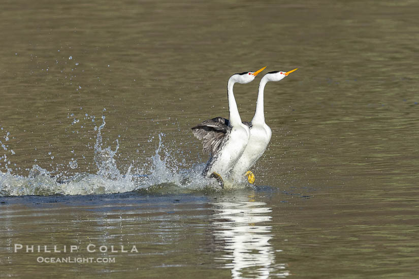
San Diego, Phillip Colla Photography

San Diego Pictures

Filed under: California, Photoshelter, San Diego on 7/30/2009

My San Diego pictures are now on Photoshelter in addition to the photos of San Diego on this website. There is even a nifty slideshow of them. Don’t watch too long, however, or you will want to move out here.

San Diego Coronado Bridge, known locally as the Coronado Bridge, links San Diego with Coronado, California.  The bridge was completed in 1969 and was a toll bridge until 2002.  It is 2.1 miles long and reaches a height of 200 feet above San Diego Bay.  Coronado Island is to the left, and downtown San Diego is to the right in this view looking north, Keywords: aerial, aerial photo, california, coronado bay bridge, coronado bridge, san diego, san diego coronado bridge, usa, city, downtown, scene, urban, view, vista, bay, bridge, harbor, marine, ocean, sea, span, transportation, water, coronado, freeway, road, landmark, scenic, structure, travel, marina, outdoors, outside, tourism, island, above, over,  Copyright Phillip Colla, image #22288, all rights reserved worldwide.
San Diego Coronado Bridge, known locally as the Coronado Bridge, links San Diego with Coronado, California. The bridge was completed in 1969 and was a toll bridge until 2002. It is 2.1 miles long and reaches a height of 200 feet above San Diego Bay. Coronado Island is to the left, and downtown San Diego is to the right in this view looking north. San Diego, California, USA.
Image ID: 22288  
Location: San Diego, California, USA
Click To View This Location in Google Earth.  You must have Google Earth installed for this feature to work correctly. View this Image in Google Earth!


Keywords: San Diego pictures, San Diego, California, stock photo, picture, landscape, scenic, travel, image, photograph.

Add a comment

Subscribe to this feed - Subscribe via Feedburner - Stumble it! - Digg this! - Add to Del.icio.us - Share on Facebook

Miscellanea

Filed under: Info, Get The, Photography, San Diego on 4/30/2009

Trey Ratcliffe has a great tutorial on HDR. Boy does he produce some incredible images, really fantastic stuff.

Trying to figure out Twitter, what its all about and whether it is useful. Right now it seems a bit over-busy, but could foster some new connections. Tweetdeck is a popular free app that seems to make it much easier to use.

Photoshelter has published the best tutorial on Photography Websites I have ever seen. None of this information is new, but it is assembled in one fairly concise presentation. It is worth watching even if you are not a Photoshelter user. (You may become one.)

Made a 5′ print of this San Diego City Skyline Panorama Photo at Giant Photo for a client. The print turned out fantastic and the client is thrilled. I am quite impressed with Giant Photo’s service, looking forward to making more big prints with them.

San Diego city skyline at sunset, showing the buildings of downtown San Diego rising above San Diego Harbor, viewed from Harbor Island.  A panoramic photograph, composite of thirteen separate images.,  Copyright Phillip Colla, image #22255, all rights reserved worldwide.
San Diego city skyline at sunset, showing the buildings of downtown San Diego rising above San Diego Harbor, viewed from Harbor Island. A panoramic photograph, composite of thirteen separate images. San Diego, California, USA.
Image: 22255  
Location: San Diego, California, USA
Click To View This Location in Google Earth.  You must have Google Earth installed for this feature to work correctly. View this Image in Google Earth!

Pano dimensions: 4759 x 15430
 
Add a comment

Subscribe to this feed - Subscribe via Feedburner - Stumble it! - Digg this! - Add to Del.icio.us - Share on Facebook

Tijuana River Pollution, San Diego

Filed under: California, San Diego on 2/27/2009

The Tijuana River Valley, which skirts the U.S. - Mexico border, has a huge pollution problem. The Tijuana River, which passes through Tijuana before crossing into the United States, collects huge amounts of trash and debris with each winter’s storms. The plastic bottles, cans, tires, garbage bags, clothes, and sewage then washes downstream into the United States. While the liquid pollutants flow with the river until it empties into the Pacific Ocean in Imperial Beach, the rest of the debris washes up on the edges of the Tijuana River Valley or is trapped in vegetation. It is a depressing sight to behold.

Pollution accumulates in the Tijuana River Valley following winter storms which flush the trash from Tijuana in Mexico across the border into the United States.,  Copyright Phillip Colla, image #22544, all rights reserved worldwide.
Pollution accumulates in the Tijuana River Valley following winter storms which flush the trash from Tijuana in Mexico across the border into the United States. Imperial Beach, San Diego, California, USA.
Image: 22544  
Location: Imperial Beach, San Diego, California, USA
Click To View This Location in Google Earth.  You must have Google Earth installed for this feature to work correctly. View this Image in Google Earth!

 
Pollution accumulates in the Tijuana River Valley following winter storms which flush the trash from Tijuana in Mexico across the border into the United States.,  Copyright Phillip Colla, image #22546, all rights reserved worldwide.
Pollution accumulates in the Tijuana River Valley following winter storms which flush the trash from Tijuana in Mexico across the border into the United States. Imperial Beach, San Diego, California, USA.
Image: 22546  
Location: Imperial Beach, San Diego, California, USA
Click To View This Location in Google Earth.  You must have Google Earth installed for this feature to work correctly. View this Image in Google Earth!

 
Pollution accumulates in the Tijuana River Valley following winter storms which flush the trash from Tijuana in Mexico across the border into the United States.,  Copyright Phillip Colla, image #22549, all rights reserved worldwide.
Pollution accumulates in the Tijuana River Valley following winter storms which flush the trash from Tijuana in Mexico across the border into the United States. Imperial Beach, San Diego, California, USA.
Image: 22549  
Location: Imperial Beach, San Diego, California, USA
Click To View This Location in Google Earth.  You must have Google Earth installed for this feature to work correctly. View this Image in Google Earth!

 
Pollution accumulates in the Tijuana River Valley following winter storms which flush the trash from Tijuana in Mexico across the border into the United States.,  Copyright Phillip Colla, image #22555, all rights reserved worldwide.
Pollution accumulates in the Tijuana River Valley following winter storms which flush the trash from Tijuana in Mexico across the border into the United States. Imperial Beach, San Diego, California, USA.
Image: 22555  
Location: Imperial Beach, San Diego, California, USA
Click To View This Location in Google Earth.  You must have Google Earth installed for this feature to work correctly. View this Image in Google Earth!


See more Tijuana River Valley pollution photos and Imperial Beach pollution photos.

Add a comment

Subscribe to this feed - Subscribe via Feedburner - Stumble it! - Digg this! - Add to Del.icio.us - Share on Facebook

Downtown San Diego and USS Midway

View This Blog Post in Google Earth (How Cool Is That?)  View this blog entry in Google Earth
Latitude: 32° 42' 43.99" N, Longitude: 117° 10' 45.62" W, Coord: 32.71222°, -117.17934°
Filed under: California, San Diego on 2/14/2009

One more photo of San Diego, then on to other things. Seen here are the high rise office buildings along the waterfront of downtown San Diego, lit with warm sunset light. Dominating the foreground is the USS Midway, a US Navy aircraft carrier that is now permanently docked in San Diego and which serves as a naval museum and a testament to San Diego’s rich Navy tradition and history.

Downtown San Diego and USS Midway.  The USS Midway was a US Navy aircraft carrier, launched in 1945 and active through the Vietnam War and Operation Desert Storm, as of 2008 a museum along the downtown waterfront in San Diego.,  Copyright Phillip Colla, image #22289, all rights reserved worldwide.
Downtown San Diego and USS Midway. The USS Midway was a US Navy aircraft carrier, launched in 1945 and active through the Vietnam War and Operation Desert Storm, as of 2008 a museum along the downtown waterfront in San Diego. San Diego, California, USA.
Image: 22289  
Location: San Diego, California, USA
Click To View This Location in Google Earth.  You must have Google Earth installed for this feature to work correctly. View this Image in Google Earth!


See more Photos of San Diego.

Add a comment

Subscribe to this feed - Subscribe via Feedburner - Stumble it! - Digg this! - Add to Del.icio.us - Share on Facebook

Coast Highway 101

View This Blog Post in Google Earth (How Cool Is That?)  View this blog entry in Google Earth
Latitude: 32° 56' 19.31" N, Longitude: 117° 15' 39.74" W, Coord: 32.9387°, -117.26104°
Filed under: California, San Diego on 2/13/2009

The Coast Highway, also known as Highway 101 or Coast Blvd, is one of the gems of San Diego County. It takes on somewhat different names as it passes through the beachside communities of La Jolla, Del Mar, Solana Beach, Encinitas and Carlsbad. It passes spectacular ocean views, funky cafes and galleries, upscale restaurants, a few state parks and some very nice real estate. In this photo looking south, the Coast Highway passes alongside Torrey Pines State Beach and climbs past Torrey Pines Reserve. La Jolla is in the distance. The mouth of Los Penasquitos Marsh connects with the ocean in the center of the photograph. If you are a runner, consider this stretch of highway and beach “A-list.”

Coast Highway 101, looking south from Del Mar, with Los Penasquitos Marsh on the left and the cliffs of Torrey Pines State Reserve and La Jolla in the distance.,  Copyright Phillip Colla, image #22310, all rights reserved worldwide.
Coast Highway 101, looking south from Del Mar, with Los Penasquitos Marsh on the left and the cliffs of Torrey Pines State Reserve and La Jolla in the distance. San Diego, California, USA.
Image: 22310  
Location: San Diego, California, USA
Click To View This Location in Google Earth.  You must have Google Earth installed for this feature to work correctly. View this Image in Google Earth!


See more Photos of San Diego.

Add a comment

Subscribe to this feed - Subscribe via Feedburner - Stumble it! - Digg this! - Add to Del.icio.us - Share on Facebook

San Diego Convention Center

View This Blog Post in Google Earth (How Cool Is That?)  View this blog entry in Google Earth
Latitude: 32° 42' 5.83" N, Longitude: 117° 9' 41.32" W, Coord: 32.70162°, -117.16148°
Filed under: California, San Diego on 2/12/2009

We made several loops over downtown as the sun dropped to the horizon, eventually passing by the San Diego Covention Center. It is really a big facility and looks quite different from the air than when I have seen it from the entrance near the Gaslamp District. Just a few seconds after the photo below was made, I took a nice photo of Petco Park just a short distance away (as the crow flies).

San Diego Convention Center, located in the Marina District of downtown San Diego.  Built in 1989, the San Diego Convention Center offers 525,700 square feet of exhibit space.  It is noted for its distinctive sails made of Teflon-coated fiberglass suspended over the central exhibition hall, aptly named Sails Pavilion.,  Copyright Phillip Colla, image #22290, all rights reserved worldwide.
San Diego Convention Center, located in the Marina District of downtown San Diego. Built in 1989, the San Diego Convention Center offers 525,700 square feet of exhibit space. It is noted for its distinctive “sails” made of Teflon-coated fiberglass suspended over the central exhibition hall, aptly named Sails Pavilion. San Diego, California, USA.
Image: 22290  
Location: San Diego, California, USA
Click To View This Location in Google Earth.  You must have Google Earth installed for this feature to work correctly. View this Image in Google Earth!


See more Photos of San Diego.

Add a comment

Subscribe to this feed - Subscribe via Feedburner - Stumble it! - Digg this! - Add to Del.icio.us - Share on Facebook

Petco Park and Downtown San Diego

View This Blog Post in Google Earth (How Cool Is That?)  View this blog entry in Google Earth
Latitude: 32° 42' 25.3" N, Longitude: 117° 9' 17.96" W, Coord: 32.70703°, -117.15499°
Filed under: California, San Diego on 2/10/2009

Here is a view of Petco Park and downtown San Diego with San Diego Bay in the background.

Downtown San Diego and Petco Park, viewed from the southeast.,  Copyright Phillip Colla, image #22300, all rights reserved worldwide.
Downtown San Diego and Petco Park, viewed from the southeast. San Diego, California, USA.
Image: 22300  
Location: San Diego, California, USA
Click To View This Location in Google Earth.  You must have Google Earth installed for this feature to work correctly. View this Image in Google Earth!


See more of our San Diego Photos.

Add a comment

Subscribe to this feed - Subscribe via Feedburner - Stumble it! - Digg this! - Add to Del.icio.us - Share on Facebook

Coronado Bridge, San Diego

View This Blog Post in Google Earth (How Cool Is That?)  View this blog entry in Google Earth
Latitude: 32° 40' 59.55" N, Longitude: 117° 9' 18.43" W, Coord: 32.68321°, -117.15512°
Filed under: California, San Diego on 2/9/2009

One of the most striking sights during our flight over San Diego was the San Diego - Coronado Bridge. Arching high over San Diego Bay, the Coronado Bridge connects San Diego with the “island” community of Coronado and North Island Naval Air Station. Coronado is not truly an island as it is connected with the mainland with the long, skinny Strand, but approaching Coronado along the Strand requires a long detour through Imperial Beach. The Coronado Bridge was built high enough that large Navy boats can sail beneath it. And the bridge sections are designed to float so that, in the event that a disaster occurs and the bridge is destroyed, the bridge pieces can be easily moved out of the way so that Navy vessels can move quickly through the area. In this photo looking north, Coronado Island is seen to the left and downtown San Diego to the right.

San Diego Coronado Bridge, known locally as the Coronado Bridge, links San Diego with Coronado, California.  The bridge was completed in 1969 and was a toll bridge until 2002.  It is 2.1 miles long and reaches a height of 200 feet above San Diego Bay.  Coronado Island is to the left, and downtown San Diego is to the right in this view looking north.,  Copyright Phillip Colla, image #22288, all rights reserved worldwide.
San Diego Coronado Bridge, known locally as the Coronado Bridge, links San Diego with Coronado, California. The bridge was completed in 1969 and was a toll bridge until 2002. It is 2.1 miles long and reaches a height of 200 feet above San Diego Bay. Coronado Island is to the left, and downtown San Diego is to the right in this view looking north. San Diego, California, USA.
Image: 22288  
Location: San Diego, California, USA
Click To View This Location in Google Earth.  You must have Google Earth installed for this feature to work correctly. View this Image in Google Earth!


See more of our San Diego Photos.

Add a comment

Subscribe to this feed - Subscribe via Feedburner - Stumble it! - Digg this! - Add to Del.icio.us - Share on Facebook

Hotel del Coronado, San Diego

View This Blog Post in Google Earth (How Cool Is That?)  View this blog entry in Google Earth
Latitude: 32° 40' 40.33" N, Longitude: 117° 10' 46.73" W, Coord: 32.67787°, -117.17965°
Filed under: California, San Diego on 2/7/2009

An aerial photo of the Hotel del Coronado, known affectionately as the Hotel Del. It was once the largest hotel in the world, and is one of the country’s few remaining wooden Victorian beach resorts. It sits on the beach on Coronado Island, seen here with downtown San Diego in the distance. It is widely considered to be one of Americas most beautiful and classic hotels. Built in 1888, it was designated a National Historic Landmark in 1977.

Hotel del Coronado, known affectionately as the Hotel Del.  It was once the largest hotel in the world, and is one of the few remaining wooden Victorian beach resorts.  It sits on the beach on Coronado Island, seen here with downtown San Diego in the distance.  It is widely considered to be one of Americas most beautiful and classic hotels. Built in 1888, it was designated a National Historic Landmark in 1977.,  Copyright Phillip Colla, image #22287, all rights reserved worldwide.
The Hotel del Coronado, San Diego, California, USA.
Image: 22287  
Location: San Diego, California, USA
Click To View This Location in Google Earth.  You must have Google Earth installed for this feature to work correctly. View this Image in Google Earth!


See more of our San Diego Photos.

Add a comment

Subscribe to this feed - Subscribe via Feedburner - Stumble it! - Digg this! - Add to Del.icio.us - Share on Facebook

Old Point Loma Lighthouse, San Diego

View This Blog Post in Google Earth (How Cool Is That?)  View this blog entry in Google Earth
Latitude: 32° 40' 18.26" N, Longitude: 117° 14' 46.42" W, Coord: 32.67174°, -117.24623°
Filed under: California, San Diego on 2/6/2009

The original Point Loma lighthouse was built in 1855 and operated until 1891. It was one of the original 8 lighthouses built on the West Coast and was designed in the Cape Cod style common to all of them at the time. East Coast lighthouses were then built on promontories and hill tops so it was natural to do so on the West Coast as well. This was soon realized to be a major blunder: the lighthouses were too high for the weather, above the low-lying fog that is common on the West Coast, and thus not visible to coastal mariners. In 1891 the Point Loma lighthouse was replaced by another one closer to sea level. The “old” Point Loma lighthouse, which has been refurbished to its 1880’s condition, is now the principal attraction of Cabrillo National Monument and offers unobstructed views of San Diego Bay, North Island Naval Air Station and Coronado Island, Mexico’s Islas Coronado and the Pacific Ocean.

Old Point Loma Lighthouse, sitting high atop the end of Point Loma peninsula, seen here with San Diego Bay and downtown San Diego in the distance.  The old Point Loma lighthouse operated from 1855 to 1891 above the entrance to San Diego Bay. It is now a maintained by the National Park Service and is part of Cabrillo National Monument,  Copyright Phillip Colla, image #22301, all rights reserved worldwide.
Old Point Loma Lighthouse, sitting high atop the end of Point Loma peninsula, seen here with San Diego Bay and downtown San Diego in the distance. The old Point Loma lighthouse operated from 1855 to 1891 above the entrance to San Diego Bay. It is now a maintained by the National Park Service and is part of Cabrillo National Monument. San Diego, California, USA.
Image: 22301  
Location: San Diego, California, USA
Click To View This Location in Google Earth.  You must have Google Earth installed for this feature to work correctly. View this Image in Google Earth!


See more Photos of San Diego.

Add a comment

Subscribe to this feed - Subscribe via Feedburner - Stumble it! - Digg this! - Add to Del.icio.us - Share on Facebook

Crystal Pier, San Diego

View This Blog Post in Google Earth (How Cool Is That?)  View this blog entry in Google Earth
Latitude: 32° 47' 52.4" N, Longitude: 117° 15' 46.29" W, Coord: 32.79789°, -117.26286°
Filed under: California, San Diego on 2/5/2009

Crystal Pier, a combination hotel and pier in the Pacific Beach community of San Diego, extends 872 feet out into the Pacific Ocean. A few dozen cottages sit on the pier near its base. It was built in 1925. Seen beyond Crystal Pier in this aerial photo are Mission Bay and, to the upper right, downtown San Diego.

Crystal Pier, 872 feet long and built in 1925, extends out into the Pacific Ocean from the town of Pacific Beach.  Mission Bay and downtown San Diego are seen in the distance.,  Copyright Phillip Colla, image #22294, all rights reserved worldwide.
Crystal Pier, 872 feet long and built in 1925, extends out into the Pacific Ocean from the town of Pacific Beach. Mission Bay and downtown San Diego are seen in the distance. San Diego, California, USA.
Image: 22294  
Location: San Diego, California, USA
Click To View This Location in Google Earth.  You must have Google Earth installed for this feature to work correctly. View this Image in Google Earth!


See more of our San Diego Photos.

Add a comment

Subscribe to this feed - Subscribe via Feedburner - Stumble it! - Digg this! - Add to Del.icio.us - Share on Facebook

Ocean Beach Pier, San Diego

View This Blog Post in Google Earth (How Cool Is That?)  View this blog entry in Google Earth
Latitude: 32° 45' 10.11" N, Longitude: 117° 15' 29.66" W, Coord: 32.75281°, -117.25824°
Filed under: California, San Diego on 2/3/2009

Here is a view of the Ocean Beach Pier (”OB Pier”) with Sunset Cliffs and Point Loma, and even one of the Coronado Islands in the distance.

Ocean Beach Pier, also known as the OB Pier or Ocean Beach Municipal Pier, is the longest concrete pier on the West Coast measuring 1971 feet (601 m) long.  Sunset Cliffs and Point Loma extend off to the south.,  Copyright Phillip Colla, image #22459, all rights reserved worldwide.
Ocean Beach Pier, also known as the OB Pier or Ocean Beach Municipal Pier, is the longest concrete pier on the West Coast measuring 1971 feet (601 m) long. Sunset Cliffs and Point Loma extend off to the south. San Diego, California, USA.
Image: 22459  
Location: San Diego, California, USA
Click To View This Location in Google Earth.  You must have Google Earth installed for this feature to work correctly. View this Image in Google Earth!


See more photos of San Diego

Add a comment

Subscribe to this feed - Subscribe via Feedburner - Stumble it! - Digg this! - Add to Del.icio.us - Share on Facebook

Torrey Pines State Beach

View This Blog Post in Google Earth (How Cool Is That?)  View this blog entry in Google Earth
Latitude: 32° 54' 51.62" N, Longitude: 117° 15' 34.27" W, Coord: 32.91434°, -117.25952°
Filed under: California, Panoramas, Photo of the Day, Photography, San Diego on 2/1/2009

A panorama of the view from Flat Rock at sunset, viewed with your back to the sun facing the tall sandstone seacliffs that tower over Torrey Pines State Beach. This was shot from the place where yesterday’s Oranjeboom couple was standing. This panoramic photo is a composite of 10 separate photos I took by standing in one spot and spinning really fast while firing the camera on its fast motor drive. In spite of being hand-held (the best panoramas use a tripod and good technique) this particular one stitched flawlessly on the computer so that one cannot tell where one photo ends and the next begins. It is awesome in the amount of detail that it contains. If you like this you can see many more panorama photos I’ve made.

Torrey Pines State Beach, sandstone cliffs rise above the beach at Torrey Pines State Reserve.,  Copyright Phillip Colla, image #22445, all rights reserved worldwide.
Torrey Pines State Beach, sandstone cliffs rise above the beach at Torrey Pines State Reserve. Torrey Pines State Reserve, San Diego, California, USA.
Image: 22445  
Location: Torrey Pines State Reserve, San Diego, California, USA
Pano dimensions: 4922 x 18300
 

See more photos of Torrey Pines State Beach and more panoramic photos

Add a comment

Subscribe to this feed - Subscribe via Feedburner - Stumble it! - Digg this! - Add to Del.icio.us - Share on Facebook

Flat Rock, Torrey Pines State Natural Reserve

View This Blog Post in Google Earth (How Cool Is That?)  View this blog entry in Google Earth
Latitude: 32° 54' 51.62" N, Longitude: 117° 15' 34.27" W, Coord: 32.91434°, -117.25952°
Filed under: California, San Diego on 1/31/2009

A couple more photos of Torrey Pines today and tomorrow, then on to other things. One of the main trails in Torrey Pines State Reserve leads down to the beach, to a flat rock that is surprisingly named “Flat Rock.” As we flew over Flat Rock a couple was enjoying the late afternoon sun on the rock, watching us as we passed by. Are those beers in their hands? I zoomed in 100% in the high res photo and indeed they are sampling the grain. Classic! Oops, did I just say that? How impolitic of me. What I meant was: Awful, wanton, bad, bad people, inconsiderate drunks from out of town who should know better. Hard to fault them though, it was a great afternoon for it. Tomorrow I will post a panoramic view from where they were standing.

Torrey Pines seacliffs, rising up to 300 feet above the ocean, stretch from Del Mar to La Jolla.  On the mesa atop the bluffs are found Torrey pine trees, one of the rare species of pines in the world.,  Copyright Phillip Colla, image #22463, all rights reserved worldwide.
Torrey Pines seacliffs, rising up to 300 feet above the ocean, stretch from Del Mar to La Jolla. On the mesa atop the bluffs are found Torrey pine trees, one of the rare species of pines in the world. Torrey Pines State Reserve, San Diego, California, USA.
Image: 22463  
Location: Torrey Pines State Reserve, San Diego, California, USA
Click To View This Location in Google Earth.  You must have Google Earth installed for this feature to work correctly. View this Image in Google Earth!

 
Cheers from Torrey Pines!  Wish you were here...  A 200% zoom on the tiny couple in the above photo.

See more photos of San Diego

Add a comment

Subscribe to this feed - Subscribe via Feedburner - Stumble it! - Digg this! - Add to Del.icio.us - Share on Facebook

Children’s Pool, La Jolla

View This Blog Post in Google Earth (How Cool Is That?)  View this blog entry in Google Earth
Latitude: 32° 50' 52.11" N, Longitude: 117° 16' 49.58" W, Coord: 32.84781°, -117.28044°
Filed under: California, La Jolla, San Diego on 1/30/2009

Children’s Pool, also known as Casa Cove, is a pretty contentious place these days. The Children’s Pool is a simple pocket cove protected by a manmade seawall. It has a fine sand beach, calm waters and fairly good snorkeling. And harbor seals (Phoca vitulina) are often found on the beach, which has a lot of people up in arms. Seal lovers want the beach managed for the welfare of the seals. Divers and swimmers are unwilling to give up access to the beach, and some even go so far as to support physical alteration of the beach and seawall in such a way that the seals will have no choice but to depart. Children’s Pool is often in the news these days, and there are a number of websites created by interests on both sides of the issue. We’ll see how it all gets resolved, if ever. I have a lot of nice photos of harbor seals taken at the Children’s Pool, and often receive questions from people about them and the seals. Four years ago I posted my personal feelings about the harbor seals at Children’s Pool and my feelings really have not changed since then.

The Children's Pool in La Jolla, also known as Casa Cove, is a small pocket cove protected by a curving seawall, with the rocky coastline and cottages and homes of La Jolla seen behind it.,  Copyright Phillip Colla, image #22302, all rights reserved worldwide.
The Children’s Pool in La Jolla, also known as Casa Cove, is a small pocket cove protected by a curving seawall, with the rocky coastline and cottages and homes of La Jolla seen behind it. La Jolla, California, USA.
Image: 22302  
Location: La Jolla, California, USA
Click To View This Location in Google Earth.  You must have Google Earth installed for this feature to work correctly. View this Image in Google Earth!


See more photos of San Diego

Add a comment

Subscribe to this feed - Subscribe via Feedburner - Stumble it! - Digg this! - Add to Del.icio.us - Share on Facebook

Scripps Pier, Scripps Institution of Oceanography

View This Blog Post in Google Earth (How Cool Is That?)  View this blog entry in Google Earth
Latitude: 32° 51' 56.8" N, Longitude: 117° 15' 38.48" W, Coord: 32.86578°, -117.26069°
Filed under: California, La Jolla, San Diego on 1/29/2009

During the flight that Ron and I took from Del Mar to downtown, we flew over three piers. The first was Scripps Pier, the research pier that supports the Scripps Institution of Oceanography. The original wooden Scripps Pier was built in 1915 and was replaced by the modern cement pier in 1988. On the hill behind the pier can be seen many of the buildings that make up Scripps Institute of Oceanography. To the left (north) is the southern edge of Black’s Beach, while if one walked along the beach to the right (south) one would come to La Jolla Shores Beach in a few minutes. When I was in grad school I worked in the Norpax building on the far left above the sandstone bluff.

SIO Pier.  The Scripps Institution of Oceanography research pier is 1090 feet long and was built of reinforced concrete in 1988, replacing the original wooden pier built in 1915. The Scripps Pier is home to a variety of sensing equipment above and below water that collects various oceanographic data. The Scripps research diving facility is located at the foot of the pier. Fresh seawater is pumped from the pier to the many tanks and facilities of SIO, including the Birch Aquarium. The Scripps Pier is named in honor of Ellen Browning Scripps, the most significant donor and benefactor of the Institution.,  Copyright Phillip Colla, image #22293, all rights reserved worldwide.
SIO Pier. The Scripps Institution of Oceanography research pier is 1090 feet long and was built of reinforced concrete in 1988, replacing the original wooden pier built in 1915. The Scripps Pier is home to a variety of sensing equipment above and below water that collects various oceanographic data. The Scripps research diving facility is located at the foot of the pier. Fresh seawater is pumped from the pier to the many tanks and facilities of SIO, including the Birch Aquarium. The Scripps Pier is named in honor of Ellen Browning Scripps, the most significant donor and benefactor of the Institution. Scripps Institution of Oceanography, La Jolla, California, USA.
Image: 22293  
Location: Scripps Institution of Oceanography, La Jolla, California, USA
Click To View This Location in Google Earth.  You must have Google Earth installed for this feature to work correctly. View this Image in Google Earth!


See more San Diego photos and photos of Scripps Pier.

Add a comment

Subscribe to this feed - Subscribe via Feedburner - Stumble it! - Digg this! - Add to Del.icio.us - Share on Facebook

Torrey Pines Golf Course

Filed under: California, San Diego on 1/28/2009

I used to play Torrey Pines Golf Course on Friday afternoons with some buddies when I was a student at UCSD. We played both north and south courses, whichever had an earlier slot available when we got there. Each semester we would plan our class schedules so that we would be done with lectures by about 1pm on Fridays, ensuring we could shoot a full round before sunset. With a resident’s card the green fee was something like $10, and splitting a cart was another $10 or so. It was great, poor college students enjoying 18 holes on one of the finest public courses on the West coast, with perhaps the best views of any course in California. Ah, good times. These days Torrey Pines Golf Course is milked as a cash cow by the city rather than as an asset to be preserved primarily for the people that actually live in San Diego. Holding the 2008 US Open at Torrey Pines added to the misery, causing course closures before and after the event, generating traffic and crowds during the event and generally making it harder for Joe San Diego to enjoy the course in his own city. (Don’t expect to hear these sentiments from the craven town boosters and the developers they serve, however.) It is tough to get a good tee time at Torrey since a quota of the best tee times are set aside for a private hotel near the course. The remainder are distributed by a company whose priority appears to be squeezing as much revenue as possible out of each foursome (including a “processing fee”). The vibe and attitude that made Torrey Pines Golf Course so appealing is gone. Well, that’s progress for you, at least in the minds of the politicians and business interests who run things in San Diego. As in most cities, these people are remarkably good at screwing things up. However, as hard as they have tried, one thing to which the suits have not yet been able to lay waste are the views at Torrey Pines. They will always be wonderful.

Torrey Pines golf course, situated atop the magnificent 300 foot tall seacliffs, offers majestic views of the Pacific Ocean south to La Jolla.  Scattered around the course are found Torrey pine trees, one of the rare species of pines in the world.,  Copyright Phillip Colla, image #22312, all rights reserved worldwide.
Torrey Pines golf course south course holes 2, 4 and 5, Torrey Pines Golf Course, situated atop the magnificent 300 foot tall seacliffs, offers majestic views of the Pacific Ocean south to La Jolla. Scattered around the course are found Torrey pine trees, one of the rare species of pines in the world. San Diego, California, USA.
Image: 22312  
Location: San Diego, California, USA
Click To View This Location in Google Earth.  You must have Google Earth installed for this feature to work correctly. View this Image in Google Earth!

 
Torrey Pines golf course, situated atop the magnificent 300 foot tall seacliffs, offers majestic views of the Pacific Ocean south to La Jolla.  Scattered around the course are found Torrey pine trees, one of the rare species of pines in the world.  Some of La Jolla's biotechnology companies are seen on the far side of the golf course, along North Torrey Pines Road.,  Copyright Phillip Colla, image #22320, all rights reserved worldwide.
Torrey Pines golf course, situated atop the magnificent 300 foot tall seacliffs, offers majestic views of the Pacific Ocean south to La Jolla. Scattered around the course are found Torrey pine trees, one of the rare species of pines in the world. Some of La Jolla’s biotechnology companies are seen on the far side of the golf course, along North Torrey Pines Road. San Diego, California, USA.
Image: 22320  
Location: San Diego, California, USA
Click To View This Location in Google Earth.  You must have Google Earth installed for this feature to work correctly. View this Image in Google Earth!


See more stock photos of San Diego, Torrey Pines Golf Course, and photos of Torrey Pines State Reserve.

Add a comment

Subscribe to this feed - Subscribe via Feedburner - Stumble it! - Digg this! - Add to Del.icio.us - Share on Facebook

Torrey Pines State Reserve

View This Blog Post in Google Earth (How Cool Is That?)  View this blog entry in Google Earth
Latitude: 32° 55' 37.09" N, Longitude: 117° 15' 39.2" W, Coord: 32.92697°, -117.26089°
Filed under: California, San Diego on 1/27/2009

Torrey Pines State Reserve is a special place for me. When I was a kid, we drove down from Newport Beach to hike the winding dirt trails from the mesa to the beach, squeezing through the notorious and now-closed “Fat Man’s Misery” (a politically-incorrectly-named narrow trail which discriminates against the width-challenged), wondering whether we would see any free-ranging wild nudies when we reached the ocean below. (Sadly, we learned that the nudist be-ins took place further south at Black’s Beach). When I lived in Del Mar in the 80’s and 90’s I would run in Torrey Pines each day, slowly making my way up the historic old Coast Highway to the golf course on the mesa and then enjoying the downhill trail past Broken Hill and down the view-laden switchbacks to the beach at Flat Rock. We started our flight just south of Del Mar and flew over Torrey Pines State Beach, admiring the 300′ sandstone cliffs and eroded bluffs of the reserve, speckled with rare Torrey Pines trees (Pinus torreyana). I was able to make out all the trails I used to (and sometimes still do) run.

Torrey Pines seacliffs, rising up to 300 feet above the ocean, stretch from Del Mar to La Jolla.  On the mesa atop the bluffs are found Torrey pine trees, one of the rare species of pines in the world.,  Copyright Phillip Colla, image #22285, all rights reserved worldwide.
Torrey Pines seacliffs, rising up to 300 feet above the ocean, stretch from Del Mar to La Jolla. On the mesa atop the bluffs are found Torrey pine trees, one of the rare species of pines in the world. Torrey Pines State Reserve, San Diego, California, USA.
Image: 22285  
Location: Torrey Pines State Reserve, San Diego, California, USA
Click To View This Location in Google Earth.  You must have Google Earth installed for this feature to work correctly. View this Image in Google Earth!

 
Torrey Pines seacliffs, rising up to 300 feet above the ocean, stretch from Del Mar to La Jolla.  On the mesa atop the bluffs are found Torrey pine trees, one of the rare species of pines in the world.,  Copyright Phillip Colla, image #22319, all rights reserved worldwide.
Torrey Pines seacliffs, rising up to 300 feet above the ocean, stretch from Del Mar to La Jolla. On the mesa atop the bluffs are found Torrey pine trees, one of the rare species of pines in the world. Torrey Pines State Reserve, San Diego, California, USA.
Image: 22319  
Location: Torrey Pines State Reserve, San Diego, California, USA
Click To View This Location in Google Earth.  You must have Google Earth installed for this feature to work correctly. View this Image in Google Earth!


See more stock photos of San Diego and photos of Torrey Pines State Reserve.

Add a comment

Subscribe to this feed - Subscribe via Feedburner - Stumble it! - Digg this! - Add to Del.icio.us - Share on Facebook

Aerial Photos of San Diego

Filed under: California, GeoBlog, Photography, San Diego on 1/26/2009

Here are a couple of new aerial photos from our recently updated collection of San Diego Photos.

New Point Loma Lighthouse, situated on the tip of Point Loma Peninsula, marks the entrance to San Diego Bay.  The lighthouse rises 70' and was built in 1891 to replace the old  Point Loma Lighthouse which was often shrouded in fog.,  Copyright Phillip Colla, image #22295, all rights reserved worldwide.
New Point Loma Lighthouse, situated on the tip of Point Loma Peninsula, marks the entrance to San Diego Bay. The lighthouse rises 70′ and was built in 1891 to replace the “old” Point Loma Lighthouse which was often shrouded in fog. San Diego, California, USA.
Image: 22295  
Location: San Diego, California, USA
Click To View This Location in Google Earth.  You must have Google Earth installed for this feature to work correctly. View this Image in Google Earth!

 
Downtown San Diego and Petco Park, viewed from the southeast.,  Copyright Phillip Colla, image #22300, all rights reserved worldwide.
Downtown San Diego and Petco Park, viewed from the southeast. San Diego, California, USA.
Image: 22300  
Location: San Diego, California, USA
Click To View This Location in Google Earth.  You must have Google Earth installed for this feature to work correctly. View this Image in Google Earth!


Recently I had a chance to go flying with Ron Niebrugge, an Alaska-based photographer who spends a lot of time shooting in California in winter months. We had a picture-perfect flight, just super, and managed to fly over most of the landmarks we had on our wish list. If you use Google Earth, you can see the flight track we had as well as a sampling of the images I took positioned where they were taken by clicking both of the following two links (you’ll need Google Earth installed for this to work):

http://www.oceanlight.com/kml.php?file=20090116.kml
http://www.oceanlight.com/22285-22305.kml

I managed a lot of keepers and will be posting some of them in the coming days.

Add a comment

Subscribe to this feed - Subscribe via Feedburner - Stumble it! - Digg this! - Add to Del.icio.us - Share on Facebook

San Diego Waterfront from Coronado Island

View This Blog Post in Google Earth (How Cool Is That?)  View this blog entry in Google Earth
Latitude: 32° 42' 27.03" N, Longitude: 117° 9' 56.84" W, Coord: 32.70751°, -117.16579°
Filed under: California, Panoramas, Photo of the Day, Photography, San Diego on 1/12/2009

Here is the last shot of the San Diego city skyline, over San Diego Bay, taken about an hour after the first one and the middle one, viewed from Coronado Island:

San Diego city skyline at night, showing the buildings of downtown San Diego reflected in the still waters of San Diego Harbor, viewed from Coronado Island.  A panoramic photograph, composite of seven separate images.,  Copyright Phil Colla, image #22254, all rights reserved worldwide.
San Diego city skyline at night, showing the buildings of downtown San Diego reflected in the still waters of San Diego Harbor, viewed from Coronado Island. A panoramic photograph, composite of seven separate images. San Diego, California, USA.
Image: 22254  
Location: San Diego, California, USA
Click To View This Location in Google Earth.  You must have Google Earth installed for this feature to work correctly. View this Image in Google Earth!

Pano dimensions: 5219 x 13486
 

See more of our San Diego City Skyline Panoramic Photos (or more panorama photos from places other than San Diego). They were shot with a 21 megapixel camera and consist of anywhere from four to thirteen separate frames. The amount of detail in these images is staggering, they can be printed absolutely huge! Maybe even lifesize?

Add a comment

Subscribe to this feed - Subscribe via Feedburner - Stumble it! - Digg this! - Add to Del.icio.us - Share on Facebook

Older Posts »

HOME | Online Image Search | Photo of the Day | Contact / Bio | Licensing/Pricing | Prints | Stock List | Image Hierarchy | List of Log Entries | Site Map | Blue Whale | Cetaceans | Pinnipeds | Sharks | Rays | Fishes | Kelp Forest | Sea Birds | Inverts | Man & Animal | Man & Ocean | Ocean & Light | Ocean & Motion | Portraits | About Color and Monitor Calibration | Copyright Statement | All text and photographs copyright © Phillip Colla Natural History Photography   All rights reserved worldwide. The content of this site is made available for purposes of researching images offered for license by Phillip Colla Natural History Photography.  No image is to be copied, duplicated, modified or redistributed in whole or part without the prior written permission of Phillip Colla Natural History Photography.  Whale logo is a trademark of Phillip Colla Natural History Photography, 7302 Azalea Place, Carlsbad, CA 92011, USA.  (760) 804-0731.  Email: oceanlight@OceanLight.com    Web: www.OceanLight.com      Portfolios: www.Gygis.com

Updated: November 7, 2009