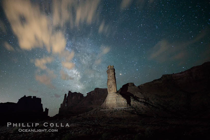
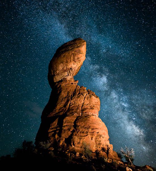
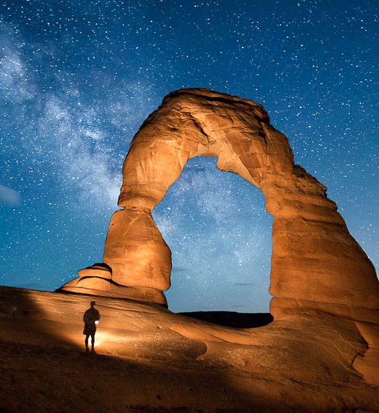
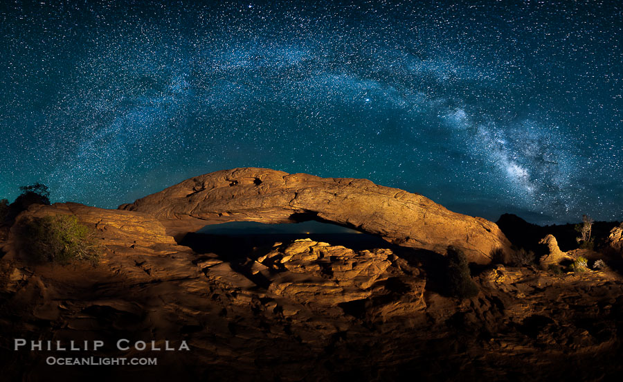
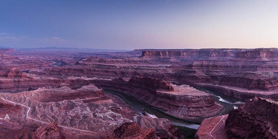
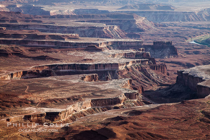
National Parks, Natural History Photography Blog

Eureka Valley Dune Grass, Swallenia alexandrae

View This Blog Post in Google Earth (How Cool Is That?)  View this blog entry in Google Earth
Latitude: 37° 6' 17.64" N, Longitude: 117° 40' 30.79" W, Coord: 37.1049°, -117.67522°
Filed under: California, Death Valley, Desert, Flora, National Parks on 6/10/2010

Stock photos of the Eureka Valley Dune Grass, Swallenia alexandrae, in Death Valley National Park.

The Eureka Valley Dune Grass (Swallenia alexandrae) is a federally endangered grass found only in the Eureka Valley, in the far northern reaches of Death Valley National Park. Swallenia is a monotypic genus, consisting only of the one species alexandrae. The grass is a rhizome, forming horizontal stems that spread laterally underneath the sand, producing new roots and shoots that lead to a tufted aggregation of the plant. This perennial grass grows on the slopes of the Eureka Valley Sand Dunes. In the past its survival was threatened by off-road vehicles, which were prohibited by BLM in the Eureka Valley in 1976 with enforcement effectively beginning in 1980. The area became part of Death Valley National Park in 1994. We found a number of small tufts of Eureka Valley Dune Grass on the dunes. This one depicts the Last Chance Mountain Range in the background, viewed from the north end of the dunes.

Eureka dune grass, and rare and federally endangered species of grass  endemic to the Eureka Valley and Eureka Sand Dunes.  The Last Chance mountains, lit by sunset, as visible in the distance.  Swallenia alexandrae, a perennial grass, grows only in the southern portion of Eureka Valley Sand Dunes, in Inyo County, California, Swallenia alexandrae, Eureka Dunes, Death Valley National Park
Eureka dune grass, and rare and federally endangered species of grass endemic to the Eureka Valley and Eureka Sand Dunes. The Last Chance mountains, lit by sunset, as visible in the distance. Swallenia alexandrae, a perennial grass, grows only in the southern portion of Eureka Valley Sand Dunes, in Inyo County, California.
Image ID: 25358  
Species: Eureka Valley dune grass, Eureka dunegrass, Swallenia alexandrae
Location: Eureka Dunes, Death Valley National Park, California, USA
 

The Eureka Valley Sand Dunes are home to another notable and imperiled plant species, which I blogged about recently: the Eureka Valley Evening Primrose (Oenothera californica eurekensis)

Eureka Valley Evening Primrose, Oenothera californica eurekensis

View This Blog Post in Google Earth (How Cool Is That?)  View this blog entry in Google Earth
Latitude: 33° 17' 47.79" N, Longitude: 117° 39' 34.92" W, Coord: 33.29661°, -117.6597°
Filed under: California, Death Valley, Desert, Flora, National Parks, Wildflowers on 6/4/2010

Stock photos of the Eureka Valley Dune Evening Primrose, Oenothera californica eurekensis, in Death Valley National Park.

The Eureka Valley Evening Primrose (Oenothera californica eurekensis) is a federally endangered wildflower found only on and near the sand dune habitat of the Eureka Valley, in the far northern reaches of Death Valley National Park. Observed primarily at the Eureka Sand Dunes, it is also found on the nearby Saline Spur Dunes and Marble Canyon Dunes. According to a 2007 review of the 1982 recovery plan for the species, the Eureka Valley Evening Primrose is “a subspecies with a moderate degree of threat and a high recovery potential.” During spring and fall seasons that have enough rainfall, the plant blooms (typically April through June) with large white flowers that turn red as they age. As soon as I saw the first one, it instantly reminded me of its close cousin, the Dune Evening Primrose that I have seen in Anza Borrego. I am intrigued at how severely ecologically isolated the Eureka Valley Evening Primrose is, existing on just three sets of sand dunes. Sort of like a plant found on only a tiny atoll in the middle of the ocean, but this is the desert. Because of its rare nature and the wherethehellamI habitat in which it resides, it is now one of my favorite flowers.

Eureka Valley Dune Evening Primrose.  A federally endangered plant, Oenothera californica eurekensis is a perennial herb that produces white flowers from April to June. These flowers turn red as they age. The Eureka Dunes evening-primrose is found only in the southern portion of Eureka Valley Sand Dunes system in Indigo County, California, Oenothera californica eurekensis, Death Valley National Park
Eureka Valley Dune Evening Primrose. A federally endangered plant, Oenothera californica eurekensis is a perennial herb that produces white flowers from April to June. These flowers turn red as they age. The Eureka Dunes evening-primrose is found only in the southern portion of Eureka Valley Sand Dunes system in Indigo County, California.
Image ID: 25237  
Species: Oenothera californica eurekensis
Location: Eureka Dunes, Death Valley National Park, California, USA
 
Eureka Valley Dune Evening Primrose.  A federally endangered plant, Oenothera californica eurekensis is a perennial herb that produces white flowers from April to June. These flowers turn red as they age. The Eureka Dunes evening-primrose is found only in the southern portion of Eureka Valley Sand Dunes system in Indigo County, California, Oenothera californica eurekensis, Death Valley National Park
Image ID: 25267  

I recently made a short visit to the Eureka Dunes with my photographer friends Garry McCarthy and John Moore. We were on a sort of banzai run**, trying to cover Eureka Dunes, the Racetrack and Badwater Salt Flats in 3 days. We definitely were not looking for wildflowers, so we were fortunate to find a few Eureka Valley Evening Primroses along the outskirts of the dunes. Our visit took place in mid-May, and heading into Death Valley I figured the wildflowers were past peak and would be burnt to a crisp by the harsh conditions. Indeed, in the lower regions of the park, wildflowers that presented such an excellent display earlier in the spring were long gone. However, the floor of the Eureka Valley is at an elevation of 2800′, where conditions are much cooler. In fact, as we approached Eureka Valley, and especially on the dirt roads between Eureka Valley and Death Valley at altitudes between 2000′ and 4000′, I was surprised by the richness and variety of the wildflower displays. It really was superb, and I might consider that region for a wildflower trip in future years since it offers a ton of solitude and some awesome vistas.

The Eureka Valley Sand Dunes are home to another endangered plant species: the Eureka Valley Dune Grass, Swallenia alexandrae.

**banzai photographer (n): (1) a photographer with a working spouse and multiple kids each of whom has lots of activities that require driving all over the place during the week, help with homework in the evenings, and then driving all over the place on the weekends; (2) a photographer who crams five days of photography into a single weekend; (3) a photographer with a banzai attitude about life; (4) a photographer who photographs banzai trees.

Milky Way Time Lapse Movie

Filed under: Death Valley, National Parks, Time Lapse, Video on 5/18/2010

This is a time lapse video of the Milky Way rising in the south east sky, viewed from Death Valley. The Milky Way is our own galaxy, a thick spinning disc of stars with arms that thin as they spiral outward. Our Sun is located in one of the arms. When viewed from our Sun’s location, the Milky Way is viewed “on edge” and so appears as a broad band across the sky. The Milky Way is not aligned with the plane of the ecliptic, so it is not parallel with the paths that the moon and Sun follow across our sky. The central core of the Milky Way, which is the thick disc-like center of the galaxy, lies on the right side of this video. Some satellites and planes can be seen briefly in the video, along with a few shooting stars (meteors) near the bottom of the frame just before dawn. This was shot with two Canon digital SLR cameras over a period of about six hours, and is composed of about 500 photographs.

Yellowstone National Park Photos

Filed under: National Parks, Photoshelter, Yellowstone on 10/14/2009

My Yellowstone National Park stock photos are organized on Oceanlight.com in additional to the Yellowstone National Park pictures I have placed on Photoshelter:


Yellowstone National Park Photos - Images by Phillip Colla

Note: If you cannot see the slideshow above, then see this Yellowstone National Park photo slideshow.

Keywords: Yellowstone National Park, stock photography, pictures

Yosemite National Park Photos

Filed under: National Parks, Photoshelter, Yosemite on 10/11/2009

My Yosemite National Park stock photos are organized on Oceanlight.com in addition to the Yosemite pictures appearing on my Photoshelter account:


Yosemite Pictures - Images by Phillip Colla

If you cannot see the slideshow above, then take a look at this Yosemite National Park photo slideshow.

Keywords: Yosemite National Park, Yosemite Valley

Natural History Photography with Infrared Light

Filed under: California, Infrared, Joshua Tree, Sierra Nevada on 10/2/2009

I have recently taken to shooting infrared photos while I am out on photo excursions. The motivation for me is that, if I can easily and inexpensively produce a different type of photo from what I normally shoot, all the while not affecting my ability to shoot traditional color photos, then why not give it a try. The upside is that I might produce a few more quality, interesting images. The downside is that if the effort may be an abject failure, but if it does not cost me much in time or money then the risk is acceptable.

For instance, while I was tooling around the Bishop Creek watershed photographing fall colors, I took along my Panasonic Lumix LX3 that has been converted to shoot true infrared. What this means is that I can whip this tiny but high quality camera out of my pocket and blast off some infrared shots spontaneously. Infrared photography using external infrared-pass filters on a conventional digital camera typically requires long exposure times and a tripod, making for cumbersome shooting. However, if the camera is modified internally to allow only infrared light to reach the sensor, then long exposure times are no longer required, and one can shoot infrared photos handheld. This really makes having an infrared camera along sensible and productive. Several companies exist to perform these modifications, and they are reasonably inexpensive. Plus, you can always have them convert the camera back to visible light again (for a fee) if you don’t like the results. Probably the most popular cameras for infrared conversation right now are the Canon G9/G10 (and soon to be G11) line, but I prefer the wider angle of the Lumix LX3 so I bought a second one and had it infrared-converted. This particular image comes from the Table Mountain area, when the late afternoon sun was dropping behind the cliffs, leaving much of the hillside in shadow but the aspens in side light.

Aspen trees in fall, eastern Sierra fall colors, autumn, Populus tremuloides, Bishop Creek Canyon, Sierra Nevada Mountains
Aspen trees in fall, eastern Sierra fall colors, autumn.
Image ID: 23320  
Species: Quaking aspen, Populus tremuloides
Location: Bishop Creek Canyon, Sierra Nevada Mountains, California, USA
Click To View This Location in Google Earth.  You must have Google Earth installed for this feature to work correctly. View this Image in Google Earth!


Here is another example I was quite happy with, a single Joshua Tree framed against a deep black, cloud-free, mid-morning sky. In this case, having an infrared camera along allowed me to shoot longer than I would normally have done. The light in Joshua Tree is really only good for about 30-60 minutes after sunrise, beyond that it is too harsh to shoot good images. However, the harsher and stronger the light becomes, the greater the amount of infrared light that is reflected by certain subjects such as plants. For this reason, infrared photography is usually at its best — in midday — when visible light photography is often at its worst. The two compliment one another well.

Joshua tree, sunrise, infrared, Yucca brevifolia, Joshua Tree National Park, California
Joshua tree, sunrise, infrared.
Image ID: 22888  
Species: Joshua Tree, Yucca brevifolia
Location: Joshua Tree National Park, California, USA
 

I’m pretty happy with my little infrared-converted LX3 and its ability to shoot quick and reasonably high-quality infrared images. (Not to mention that we love our regular LX3 for snapshots and family photos.) However, I should mention there are some limitations to shooting infrared this way. The optics of todays digital cameras are designed for visible light, in particular, the wavelengths of light in the visible spectrum and how they pass through lens glass-air and glass-glass interfaces. Infrared light passes through the lens and into the sensor in a somewhat different way than visible spectrum light. I have found that this manifests in images that are softer than one would expect with visible light, and are sometimes prone to a vague “hot-spot” in the center of the image. The hot-spot seems to be in the blue color channel only, in my experience with the LX3, and only presents when the lens is at its widest angle (24mm-equivalent). By zooming in even a little bit, the hot-spot issue is alleviated. From the information I have read on some of the internet infrared photography websites, I think other cameras may exhibit both of these issues (soft focus, hot spots) as well but I am not sure as I have only used the LX3 in infrared. I believe the hot spot is a property of the camera sensor and the angle at which the light reaches the sensor, while the soft focus (most notably corner softness) is a characteristic of the optics and their transmission of light (infrared) in wavelengths quite different from those for which the lens was designed (visible). Usually I pull out either the red or green color channel to produce a black-and-white image, so the hot spot in the blue channel is not a great problem, but in those images in which I think I want the blue channel I just zoom in a little and all seems to be well. Also, the hotspot is not present in all images, it seems to have something to do with the direction of the sun and how intensely the subjects in the center of the image are reflecting infrared. Image softness is a property of infrared photography in general, and seems to me to be ameliorated somewhat by the strong contrast that infrared images typically have. In other words, the strong black-white contrast of an infrared image seems to more than make up for the soft detail, when the image is viewed as a whole.

Like this? Here are more infrared photos.

Keywords: infrared, joshua tree, yucca brevifolia, aspen, populus tremuloides.

Infrared Photo of a Giant Sequoia Tree

View This Blog Post in Google Earth (How Cool Is That?)  View this blog entry in Google Earth
Latitude: 37° 30' 48.52" N, Longitude: 119° 35' 55.67" W, Coord: 37.51348°, -119.5988°
Filed under: California, Infrared, National Parks, Sierra Nevada, Yosemite on 10/1/2009

One tree in the Mariposa Grove of Giant Sequoia trees (Sequoiadendron giganteum) is my favorite. Its huge, reasonably symmetric, and sits somewhat alone in meadow clearing so that morning light can illuminate almost the entire tree nicely. Plus, its a nice 2 mile run up through the grove from the parking lot. Usually when I arrive at The Tree I am the only person there, having seen noone on the way up the hill. It was the same this time. What a beautiful morning. I took my tiny mikro-pokket-infraredfotokam along with me and shot some photos. Below is my favorite one.

Giant sequoia tree towers over surrounding trees in a Sierra forest.  Infrared image, Sequoiadendron giganteum, Mariposa Grove, Yosemite National Park, California
Giant sequoia tree towers over surrounding trees in a Sierra forest. Infrared image.
Image ID: 23304  
Species: Giant sequoia tree, Sequoiadendron giganteum
Location: Mariposa Grove, Yosemite National Park, California, USA
Click To View This Location in Google Earth.  You must have Google Earth installed for this feature to work correctly. View this Image in Google Earth!


Like this? Here are more infrared photos.

Keywords: giant sequoia, infrared, mariposa grove, yosemite national park, Sequoiadendron giganteum.

Giant Sequoia Pictures

View This Blog Post in Google Earth (How Cool Is That?)  View this blog entry in Google Earth
Latitude: 37° 30' 47.95" N, Longitude: 119° 35' 55.42" W, Coord: 37.51332°, -119.59873°
Filed under: California, Photoshelter, Sierra Nevada, Yosemite on 9/2/2009

Many of my giant sequoia pictures are now on Photoshelter, which is the source of this nifty slideshow. Sequoia trees really are the most majestic of all plants. They are the largest (i.e., most massive) life forms on earth, and they are nearly the tallest (exceeded only by their cousins the coastal redwoods in the Pacific Northwest). Giant sequoia trees are one of the longest lived organisms on earth, exceeded in longevity most notably by Ancient Bristlecone pine trees (Pinus longaeva). Enjoy images of these “pillars of the sierra”.


Giant Sequoia Pictures - Images by Phillip Colla
A giant sequoia tree, soars skyward from the forest floor, lit by the morning sun and surrounded by other sequioas.  The massive trunk characteristic of sequoia trees is apparent, as is the crown of foliage starting high above the base of the tree, Sequoiadendron giganteum, Mariposa Grove, Yosemite National Park, California
A giant sequoia tree, soars skyward from the forest floor, lit by the morning sun and surrounded by other sequioas. The massive trunk characteristic of sequoia trees is apparent, as is the crown of foliage starting high above the base of the tree.
Image ID: 23260  
Species: Giant sequoia tree, Sequoiadendron giganteum
Location: Mariposa Grove, Yosemite National Park, California, USA
Click To View This Location in Google Earth.  You must have Google Earth installed for this feature to work correctly. View this Image in Google Earth!


My website also has many giant sequoia tree photos (Sequoiadendron giganteum).

Keywords: sequoia, giant sequoia tree, photo, picture, image, Sequoiadendron giganteum, Yosemite National Park, Sequoia National Park, California, sierra nevada.

Photos of Glacial Erratic Boulders

Filed under: California, Sierra Nevada, Yosemite on 9/1/2009

Some years ago I posted a blog entry about photos of glacial erratic boulders on Olmsted Point in Yosemite National Park. Well, I was recently there and got a few more. Glacial erratic boulders are so named because they are erratic (i.e., differ materially from the naturally occuring stone nearby) and they were deposited by slow-moving glaciers, sometimes after having been moved a considerable distance (e.g., tens of miles) from their place of origin. The boulders are carried by the glacier and then either fall off the side of the glacier as it slowly slides along, or are simply dropped in place if a glacier melts away. Olmsted Point, high above Tenaya Canyon, is a great location for seeing glacial erratic boulders. The same glaciers that sculpted nearby granite monoliths Half Dome and Cloud’s Rest, seen in the background of one these photos, also left behind many glacial erratic boulders on the rim of Tenaya Canyon when it passed by.

Glacial erratic boulders atop Olmsted Point, with the massive granite monoliths Half Dome and Clouds Rest in the background. Erratics are huge boulders left behind by the passing of glaciers which carved the granite surroundings into their present-day form.  When the glaciers melt, any boulders and other geologic material that it was carrying are left in place, sometimes many miles from their original location, Yosemite National Park, California
Glacial erratic boulders atop Olmsted Point, with the massive granite monoliths Half Dome and Clouds Rest in the background. Erratics are huge boulders left behind by the passing of glaciers which carved the granite surroundings into their present-day form. When the glaciers melt, any boulders and other geologic material that it was carrying are left in place, sometimes many miles from their original location.
Image ID: 23264  
Location: Yosemite National Park, California, USA
Click To View This Location in Google Earth.  You must have Google Earth installed for this feature to work correctly. View this Image in Google Earth!

 
Glacial erratic boulders atop Olmsted Point. Erratics are huge boulders left behind by the passing of glaciers which carved the granite surroundings into their present-day form.  When the glaciers melt, any boulders and other geologic material that it was carrying are left in place, sometimes many miles from their original location, Yosemite National Park, California
Glacial erratic boulders atop Olmsted Point. Erratics are huge boulders left behind by the passing of glaciers which carved the granite surroundings into their present-day form. When the glaciers melt, any boulders and other geologic material that it was carrying are left in place, sometimes many miles from their original location.
Image ID: 23265  
Location: Yosemite National Park, California, USA
Click To View This Location in Google Earth.  You must have Google Earth installed for this feature to work correctly. View this Image in Google Earth!


See also: Yosemite National Park photos.

Keywords: glacial erratic boulder, geology, granite, Olmsted Point, Yosemite National Park, glacier, rock, stone.

Giant Sequoia Tree Photo

View This Blog Post in Google Earth (How Cool Is That?)  View this blog entry in Google Earth
Latitude: 37° 30' 13.93" N, Longitude: 119° 36' 15.51" W, Coord: 37.50387°, -119.60431°
Filed under: California, Sierra Nevada, Yosemite on 8/31/2009

My in-laws live year-round very near the south entrance to Yosemite National Park. It only takes a few minutes for me to drive in and reach the Mariposa grove of giant sequoia trees (Sequoiadendron giganteum), so I will often go into the park early in the morning and take a run through the trees before anyone else arrives. This time I put my hiking boots on and brought a camera, hitting the trail about 6:30. There was nobody around, not even another car in the parking lot. I made a stop at the Bachelor and Three Graces (how can one not stop here?). Eventually, I found the most photogenic tree of the morning along the upper loop trail, lit nearly in its entirety by early morning sun while the surrounding trees were shaded.

A giant sequoia tree, soars skyward from the forest floor, lit by the morning sun and surrounded by other sequioas.  The massive trunk characteristic of sequoia trees is apparent, as is the crown of foliage starting high above the base of the tree, Sequoiadendron giganteum, Mariposa Grove, Yosemite National Park, California
A giant sequoia tree, soars skyward from the forest floor, lit by the morning sun and surrounded by other sequioas. The massive trunk characteristic of sequoia trees is apparent, as is the crown of foliage starting high above the base of the tree.
Image ID: 23259  
Species: Giant sequoia tree, Sequoiadendron giganteum
Location: Mariposa Grove, Yosemite National Park, California, USA
Click To View This Location in Google Earth.  You must have Google Earth installed for this feature to work correctly. View this Image in Google Earth!

 
Giant sequoia trees, roots spreading outward at the base of each massive tree, rise from the shaded forest floor, Sequoiadendron giganteum, Mariposa Grove, Yosemite National Park, California
Giant sequoia trees, roots spreading outward at the base of each massive tree, rise from the shaded forest floor.
Image ID: 23258  
Species: Giant sequoia tree, Sequoiadendron giganteum
Location: Mariposa Grove, Yosemite National Park, California, USA
Click To View This Location in Google Earth.  You must have Google Earth installed for this feature to work correctly. View this Image in Google Earth!


See more giant sequoia photos, Sequoiadendron giganteum, Mariposa Grove.

Keywords: sequoia, giant sequoia tree, photo, picture, image, Yosemite National Park, Mariposa Grove, Sequoiadendron giganteum.

Vogelsang High Sierra Camp, Yosemite National Park

Photos of Vogelsang High Sierra Camp in Yosemite National Park

Note: I made a return trip to Vogelsang High Sierra Camp with my father in August 2010.

I made another banzai speed run up to the Eastern Sierra last weekend, this time to spend two nights at reknowned Vogelsang High Sierra Camp. This was my first visit to one of Yosemite’s high country camps, and I loved it. Dating back to the 1920’s, the High Sierra Camps consist of five wilderness camps (Vogelsang, Merced, Sunrise, Glen Aulin and May Lake) at altitudes ranging from 7,000′ to 10,000′, accomodating hikers with great meals, comfortable but spartan accomodations and incredible scenery. Backpackers also camp at these High Sierra Camps, and some backpackers opt to purchase meals at the mess tent while setting up their own campsite nearby. I opted to make a reservation and pay the full price in order to stay in the tent cabins with my own bed, and was rewarded with a lighter pack and no hassles setting up my campsite or carrying a bear can. Sure, I can carry a pack with full gear, but honestly I’ve got enough heavy camera gear to deal with so why not enjoy the comforts of the full-service camp? I’d definitely opt for the tent cabin again in the future so I can spend more time shooting photos, and leave the backpacking mode to others.

Townsley Lake, a beautiful alpine lake sitting below blue sky, clouds and Fletcher Peak (right), lies amid the Cathedral Range of glacier-sculpted granite peaks in Yosemite's high country, near Vogelsang High Sierra Camp, Yosemite National Park, California, Keywords: yosemite, yosemite national park, high sierra, sierra nevada, landscape, california, environment, nature, outdoors, outside, scene, scenery, scenic, alpine, high sierra camp, sierra, vogelsang, lake, water, cathedral range, mountain, peak, townsley lake, fletcher peak, backpack, backpacking, camp, campground, vogelsang high sierra camp, wilderness,  Copyright Phillip Colla, image #23206, all rights reserved worldwide.
Townsley Lake, a beautiful alpine lake sitting below blue sky, clouds and Fletcher Peak (right), lies amid the Cathedral Range of glacier-sculpted granite peaks in Yosemite’s high country, near Vogelsang High Sierra Camp. Yosemite National Park, California, USA.
Image ID: 23206  
Location: Yosemite National Park, California, USA
Click To View This Location in Google Earth.  You must have Google Earth installed for this feature to work correctly. View this Image in Google Earth!


I took the Rafferty Creek trail from Tuolumne Meadows to Vogelsang, the shorter of the two routes, since I did not get started until after 1pm. (I spent sunrise and the morning at Schulman Grove in the White Mountains looking at ancient Bristlecone Pine trees.) The Rafferty Creek trail is reasonably straightforward, with most of the work and elevation gain done in the first three miles, after which the trail wanders through the gradual incline of Rafferty Meadows with Fletcher Peak and Vogelsang Peak growing larger with each passing mile. I treated the trail as a workout, busted a move and reached the camp about 4pm, stopping once to demolish the mondo huge ham sandwich I picked up at Schaat’s Bakkery in Bishop. I washed up, greeted my tent-cabin-mates and made my way to the mess tent for a huge satisfying dinner (chicken, soup, potatoes, veggies, homemade soda bread, salad and chocolate cake). My plans to shoot star trail photos were waylaid as I realized my bed was more appealing than the meadow behind the camp, and I crashed hard.

Vogelsang Peak (11516') at sunset, reflected in a small creek near Vogelsang High Sierra Camp in Yosemite's high country, Yosemite National Park, California, Keywords: yosemite, yosemite national park, high sierra, sierra nevada, landscape, california, environment, nature, outdoors, outside, scene, scenery, scenic, alpine, high sierra camp, sierra, vogelsang, mountain, peak, granite, vogelsang peak, backpack, backpacking, camp, campground, vogelsang high sierra camp, wilderness, water, creek, river, stream,  Copyright Phillip Colla, image #23202, all rights reserved worldwide.
Vogelsang Peak (11516′) at sunset, reflected in a Fletcher Creek near Vogelsang High Sierra Camp in Yosemite’s high country. Yosemite National Park, California, USA.
Image ID: 23202  
Location: Yosemite National Park, California, USA
Click To View This Location in Google Earth.  You must have Google Earth installed for this feature to work correctly. View this Image in Google Earth!


Next morning I made a pre-sunrise hike up to nearby Vogelsang Lake and watched the sun play upon the lake, Vogelsang Peak which rises above it, and the surrounding granite terrain of the Cathedral Range. I made it back to camp just in time for breakfast: apple nut pancakes, eggs, bacon, sausage, oatmeal — killer. I never eat this well; I had to venture out into the sticks to get this great breakfast. I returned up to the lake and beyond to make a Vogelsang Pass panoramic photo, then a swim in the lake. I saw very few people. Back to camp for a midday nap after lunch, then off for an afternoon hike to the other side of Fletcher Peak to visit Fletcher Lake, Townsley Lake and Nameless Lake. I nearly bumped into a deer at Townsley Lake; if it had been 100 years ago and I had been named Phil Crockett I would have bagged me some fresh venison with nothing but my Swiss Army knife ap for my iPhone. A breeze came up keeping the mosquitoes down and me cool among the brilliant summertime scenery, making the afternoon one of the best hikes I’ve had in years. After I got back to camp for dinner, I met my new tent mates for my second evening in camp, including a fellow who had undergone two shoulder and two knee replacements. I realized that if this bionic man could hike the full High Sierra Loop, anyone can!

Panorama of Nameless Lake, surrounded by glacier-sculpted granite peaks of the Cathedral Range, near Vogelsang High Sierra Camp, Yosemite National Park, California, Keywords: yosemite, yosemite national park, high sierra, sierra nevada, landscape, california, environment, nature, outdoors, outside, scene, scenery, scenic, alpine, high sierra camp, sierra, vogelsang, lake, water, mountain, peak, backpack, backpacking, camp, campground, vogelsang high sierra camp, panorama, panoramic, panoramic photo, view, vista, wilderness, boulder, cirque, cliff, clouds, moraine, rock, sky, stone, tarn, talus, scree,  Copyright Phillip Colla, image #23211, all rights reserved worldwide.
Panorama of Nameless Lake, surrounded by glacier-sculpted granite peaks of the Cathedral Range, near Vogelsang High Sierra Camp. Yosemite National Park, California, USA.
Image ID: 23211  
Location: Yosemite National Park, California, USA
Click To View This Location in Google Earth.  You must have Google Earth installed for this feature to work correctly. View this Image in Google Earth!

Pano dimensions: 3756 x 9102
 

Dinner the second night was equally superb: steak, potatoes, string beans, salad, homemade bread and cheesecake. After dinner I made a half-hearted attempt to shoot high-ISO images of the Milky Way as it arched over the Sierra, but passing clouds made the results less than stellar. Off to bed. My second and final morning at Vogelsang meant one more dawn visit to the Vogelsang Lake, hoping for dramatic sunrise light. It almost clicked but not quite, but the views are so awesome from Vogelsang Lake that the sunrise hike was worth it even without photos. I was able to watch the backside of Half Dome light up as the sun rose, neat. Another killer breakfast, then depart camp at 9am for the all-downhill hike back to Tuolumne along Rafferty Creek. At the car by 11:30am, slurp down a ice cold Diet Coke and then buzzing south on 395 by noon.

My GPS says I made 30 miles in 2.5 days between my walk on the Methuselah Walk in the White Mountains and my hikes to, from and about Vogelsang in Yosemite. I’m not running much these days, knees giving me problems, so the hiking was not as smooth as I expected, but it sure was worth every step. The scenery was outright spectacular, mind blowing in its simplicity and beauty. It really is God’s Country up there.

Next time I visit I’ll make a few changes. First, I will visit later in the summer to avoid the thick mosquitoes. The higher meadows, including Vogelsang Camp, were full of mosquitoes while I was there. A head net and long sleeve shirts proved to be the trick, along with DEET on the legs, and I got only a few bites. But I’d rather try the camp again when mosquitoes are less dense. Another change I will make is to start my hike to Vogelsang earlier in the day so I can take the Lyell Canyon route, which is about 12 miles (compared to 7 for the Rafferty Creek route). I hiked the length of Lyell Canyon to Donohue Pass with some high school friends 30 years ago; it was awesome and I want to see some of that area again. I will summit Vogelsang Peak next time. I was most of the way there my first morning when I reached Vogelsang Pass, but decided not to make for the peak so I could bag a few lakes that afternoon; next time I’ll take the peak just so I can experience the view which I understand is tops. Lastly, I took too much stuff. I did not need all those Powerbars — the food at the camp was plentiful and delicious. I did not need three camera batteries, nor did I need those two heavy f/2.8 zoom lenses. I’m going commando next time, stripped down to the min for speed and agility. I’m going to bring my uber-mikro-pocket-digikam for shooting while on the trail, and save the big camera for when I am on dayhikes around the camp.


Vogelsang High Sierra Camp Pictures - Images by Phillip Colla

You can see more Vogelsang High Sierra Camp photos on my website. Photoshelter also has the same collection of Vogelsang High Sierra Camp photos, along with a Vogelsang slideshow.

Keywords: Vogelsang High Sierra Camp, Yosemite National Park, photo, picture, images, stock pictures, photography.

Infrared Joshua Tree National Park

Filed under: Infrared, Joshua Tree, National Parks, Photography on 4/26/2009

I shot these this morning during a quick trip to Joshua Tree National Park. I was totally uninspired for “regular” photography this morning, and the light was not that great anyway due to high winds and dust from the night before. But the little pocket infrared camera made some interesting “alternative” images. Here are two that I kept:

Joshua tree, sunrise, infrared., Yucca brevifolia,  Copyright Phillip Colla, image #22888, all rights reserved worldwide.
Joshua tree, sunrise, infrared. Joshua Tree National Park, California, USA.
Image: 22888  
Common name: Joshua Tree
Species: Yucca brevifolia
Location: Joshua Tree National Park, California, USA
 
Unidentified yucca or agave, sunrise, infrared., Yucca brevifolia,  Copyright Phillip Colla, image #22889, all rights reserved worldwide.
Unidentified yucca or agave, sunrise, infrared. Joshua Tree National Park, California, USA.
Image: 22889  
Common name: Joshua Tree
Species: Yucca brevifolia
Location: Joshua Tree National Park, California, USA
 

Photo of Half Dome, Yosemite National Park

View This Blog Post in Google Earth (How Cool Is That?)  View this blog entry in Google Earth
Latitude: 37° 44' 36.63" N, Longitude: 119° 35' 22.34" W, Coord: 37.74351°, -119.58954°
Filed under: California, Landscape, National Parks, Sierra Nevada, Yosemite on 4/16/2009

Half Dome is the one feature most closely associated with Yosemite National Park. A vast lobe of Mesozoic-era granodiorite magma cooled to rock, Half Dome was gradually uplifted to its present altitude of 8842 ft. As the rock was exposed, weathering and exfoliation of shell-like outer layers of the rock shaped the dome portion of the rock to its current shape. The summit is easily attainable as a day hike in the summer, if you have the stamina to undertake a 17-mile roundtrip hike with 5000 feet of elevation gain from the valley floor. To say that the view from the summit is worth the effort is an understatement. If you like this, please see more of my photos of Yosemite National Park.

Half Dome and storm clouds at sunset, viewed from Sentinel Bridge.,  Copyright Phillip Colla, image #22744, all rights reserved worldwide.
Half Dome and storm clouds at sunset, viewed from Sentinel Bridge. Half Dome, Yosemite National Park, California, USA.
Image: 22744  
Location: Half Dome, Yosemite National Park, California, USA
Click To View This Location in Google Earth.  You must have Google Earth installed for this feature to work correctly. View this Image in Google Earth!


More stock photos of Yosemite National Park.

Photo of El Capitan, Yosemite National Park

View This Blog Post in Google Earth (How Cool Is That?)  View this blog entry in Google Earth
Latitude: 37° 43' 23.41" N, Longitude: 119° 37' 18.12" W, Coord: 37.72317°, -119.6217°
Filed under: California, Landscape, National Parks, Sierra Nevada, Yosemite on 4/15/2009

El Capitan, the massive granite monolith overlooking the western end of Yosemite Valley, is my favorite attraction in the park. It is beautiful and impressive from sunrise to sunset, under moonlight, in rain and when shrouded in mist. El Capitan, the largest known exposed granite block in the world, stands on the north side of the entrance to Yosemite Valley. Its name is Spanish for “the chief”, and this rock is indeed the most prominent feature of the west end of the Yosemite Valley, rivaled in significance only by Half Dome at the valley’s east end. At 3593 feet (1096 m) high, this massive rock is a popular — though difficult — climbing spot, attracting skilled big rock climbers from around the world. Visitors with binoculars can relax in El Capitan meadow to watch the climbers slowly make their way up the epic cliffs. Each year a few climbers are plucked off the sheer sides of El Capitan by a helicopter rescue team when they get in trouble. Ribbon Falls, on El Capitan’s west side, is Yosemite National Park’s highest unbroken waterfall (1612 ft, 492 m) and indeed one of the tallest in the world. Horsetail Falls, which flows off El Capitan for a few months in winter, produces a natural “firefall” for a few weeks in winter, if the conditions are right.

El Capitan eastern face, sunrise.,  Copyright Phillip Colla, image #22745, all rights reserved worldwide.
El Capitan eastern face, sunrise. Yosemite National Park, California, USA.
Image: 22745  
Location: Yosemite National Park, California, USA
Click To View This Location in Google Earth.  You must have Google Earth installed for this feature to work correctly. View this Image in Google Earth!


As an alternative to the usual view of El Capitan above, a couple days ago I posted an infrared photo of El Capitan, in which the granite face stood in stark contrast to the tree below it and the cloud-free sky above. If you like this, please see more of my Yosemite National Park stock photos.

Infrared Photo of Yosemite Falls and Leidig Meadow

I used the same digital infrared camera to photograph Leidig Meadow with upper Yosemite Falls. The skies were totally socked in, there was light rain and virtually no color, so normal color photographs were unappealing and immediately deleted. But a black and white conversion of one of the color channels from an infrared photograph gave what I felt was an attractive rendition of this picturesque Yosemite meadow. If you like this be sure to see more photos of Yosemite National Park.

Yosemite Falls, mist and and storm clouds.,  Copyright Phillip Colla, image #22767, all rights reserved worldwide.
Yosemite Falls, mist and and storm clouds. Yosemite National Park, California, USA.
Image: 22767  
Location: Yosemite National Park, California, USA
 

More infrared photographs.

Infrared Photo of El Capitan, Yosemite

View This Blog Post in Google Earth (How Cool Is That?)  View this blog entry in Google Earth
Latitude: 37° 43' 23.41" N, Longitude: 119° 37' 18.12" W, Coord: 37.72317°, -119.6217°
Filed under: California, Infrared, National Parks, Sierra Nevada, Yosemite on 4/13/2009

Here is an image of El Capitan, one of Yosemite Valley’s most iconic iconistic icons, made with an digital infrared camera. The camera senses infrared light only, rather than visible spectrum light, resulting in dark skies and foliage that glows. See more Yosemite National Park stock photos.

El Capitan eastern face, sunrise.,  Copyright Phillip Colla, image #22770, all rights reserved worldwide.
El Capitan eastern face, sunrise. Yosemite National Park, California, USA.
Image: 22770  
Location: Yosemite National Park, California, USA
Click To View This Location in Google Earth.  You must have Google Earth installed for this feature to work correctly. View this Image in Google Earth!


More infrared photographs.

Lamar Valley and Snow, Yellowstone National Park

View This Blog Post in Google Earth (How Cool Is That?)  View this blog entry in Google Earth
Latitude: 44° 54' 52.37" N, Longitude: 110° 16' 8.11" W, Coord: 44.91455°, -110.26892°
Filed under: National Parks, Panoramas, Photography, Wyoming, Yellowstone on 2/16/2009

Another panorama from our 1997 trip to Yellowstone National Park. Seen here is the Lamar Valley, sometimes referred to as America’s Serengeti for its displays of bison, elk, antelope, bear and most notably, its famous wolf packs.

Lamar Valley in winter, panorama, a composite of seven individual images.,  Copyright Phillip Colla, image #22450, all rights reserved worldwide.
Lamar Valley in winter, panorama, a composite of seven individual images.
Image: 22450  
Click To View This Location in Google Earth.  You must have Google Earth installed for this feature to work correctly. View this Image in Google Earth!

Pano dimensions: 1910 x 10669
 

This is another panorama made with the Panasonic Lumix. Since I was touring the park with my father and my daughter, and since much of what we were seeing was new to them, we were on the move and seeing as much as we could. For this reason serious photography, which usually requires time and patience, was not in the cards, so instead of setting up for “real panoramas” I would instead hop out and blast off a series of frames with our point-and-shoot. I was using the Lumix in manual mode using RAW format so I was able to process the photos into reasonably high quality images when I got home, resulting in panoramas that stitched together cleanly and have great detail.

See more panoramic photos and Yellowstone National Park photos

Madison River and Snow, Yellowstone National Park

Filed under: National Parks, Panoramas, Photography, Wyoming, Yellowstone on 2/15/2009

In 1997 we made a visit to Yellowstone National Park in late fall to see the elk rut and were blessed with a few days of light snow. Not the bone chilling cold of Yellowstone in winter, but “winter lite” just perfect for we underdressed southern Californians. We spent most of our time watching elk along the Madison River, seen here with a dusting of snow and overcast skies:

Madison River, snow-covered banks and cold winter air, panorama, composite of 7 individual photographs.,  Copyright Phillip Colla, image #22448, all rights reserved worldwide.
Madison River, snow-covered banks and cold winter air, panorama, composite of 7 individual photographs.
Image: 22448  
Pano dimensions: 3921 x 11093
 

The above panorama was made with the good gear (digital slr, good glass). You can see another panoramic photo of the Madison river shot handheld with our nifty Panasonic Lumix micro-mini-handy-cam, which stitched surprisingly well with contains super detail.

See more panoramic photos and Yellowstone National Park photos

Midway Geyser Basin Panorama, Yellowstone

View This Blog Post in Google Earth (How Cool Is That?)  View this blog entry in Google Earth
Latitude: 44° 31' 17.54" N, Longitude: 110° 49' 42.31" W, Coord: 44.52154°, -110.82842°
Filed under: National Parks, Panoramas, Photography, Wyoming, Yellowstone on 2/8/2009

Midway Geyser Basin is one of my favorite parts of Yellowstone National Park. Early mornings and cold days are great here. The Firehole River steams as it flows through the basin, and numerous hot springs on either side of the river create shifting fogs and mists. In this panorama, formed from eight separate photographs, the Firehole River flows from left to right. Obscured by the steam in the far right of the image are Grand Prismatic Spring and Excelsior Geyser.

Firehole River, natural hot spring water steaming in cold winter air, panorama, Midway Geyser Basin.,  Copyright Phillip Colla, image #22454, all rights reserved worldwide.
Firehole River, natural hot spring water steaming in cold winter air, panorama, Midway Geyser Basin.
Image: 22454  
Click To View This Location in Google Earth.  You must have Google Earth installed for this feature to work correctly. View this Image in Google Earth!

Pano dimensions: 3177 x 27696
 

See more panoramic photos

Merry Christmas!

View This Blog Post in Google Earth (How Cool Is That?)  View this blog entry in Google Earth
Latitude: 34° 3' 38.23" N, Longitude: 116° 13' 47.64" W, Coord: 34.06062°, -116.2299°
Filed under: California, Joshua Tree, National Parks, Photo of the Day on 12/25/2008
A hiker wandering the desert on Christmas Eve thrusts his arms skyward, praising the brilliance of God and Creation.  , Yucca brevifolia,  Copyright Phillip Colla, image #22203, all rights reserved worldwide.
A hiker wandering the desert on Christmas Eve thrusts his arms skyward, praising the brilliance of God and Creation. Joshua Tree National Park, California, USA.
Image: 22203  
Species: Yucca brevifolia
Location: Joshua Tree National Park, California, USA
Click To View This Location in Google Earth.  You must have Google Earth installed for this feature to work correctly. View this Image in Google Earth!

 
« Newer PostsOlder Posts »

HOME | Online Image Search | Photo of the Day | Contact / Bio | Licensing/Pricing | Prints | Stock List | Image Hierarchy | List of Log Entries | Site Map | Blue Whale | Cetaceans | Pinnipeds | Sharks | Rays | Fishes | Kelp Forest | Sea Birds | Inverts | Man & Animal | Man & Ocean | Ocean & Light | Ocean & Motion | Portraits | About Color and Monitor Calibration | Copyright Statement | All text and photographs copyright © Phillip Colla Natural History Photography   All rights reserved worldwide. The content of this site is made available for purposes of researching images offered for license by Phillip Colla Natural History Photography.  No image is to be copied, duplicated, modified or redistributed in whole or part without the prior written permission of Phillip Colla Natural History Photography.  Whale logo is a trademark of Phillip Colla Natural History Photography, 8021 Paseo Arrayan, Carlsbad, CA 92009, USA.  760.707.7153  Email: oceanlight@OceanLight.com    Web: www.OceanLight.com      Portfolios: www.Gygis.com

Updated: May 23, 2012